|
Welcome! Scroll Down for Posts and Archives.
Other Menu Options at Top |
|
|
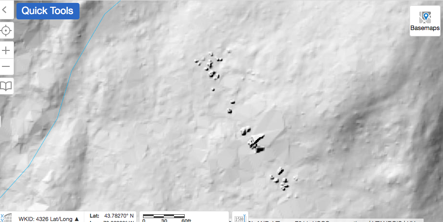 Do you see the features in the center of the LiDAR map above? I could use some help figuring out what they are! 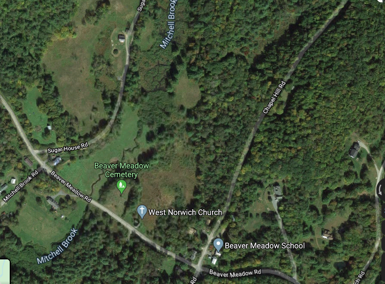 Courtesy Google Earth While preparing for a walk out Sugarhouse Road, in West Norwich, VT, I decided to look for anything interesting I might find out there, like ruins of old foundations, along the way, using LiDAR maps. That's when I found these interesting features, seen in the top photo above. My first guess is that they are very large boulders, or steep outcroppings, but I'm also wondering if they could have been made by humans. I have heard rumors of Native American ruins in that general area, though I've never been told exactly where, or what they may be. Researching with LiDAR maps is a good way to learn about an area you are about to explore. These maps can show geologic and man-made features, such as stone walls and foundations, mill sites, etc. Below is a much wider map of the area in question, showing only the LiDAR information; no overlays. You can see that you get a really good look at surface contours. 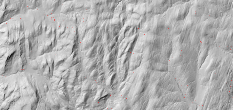 Now we'll add an overlay with some topographic lines and water features, below: 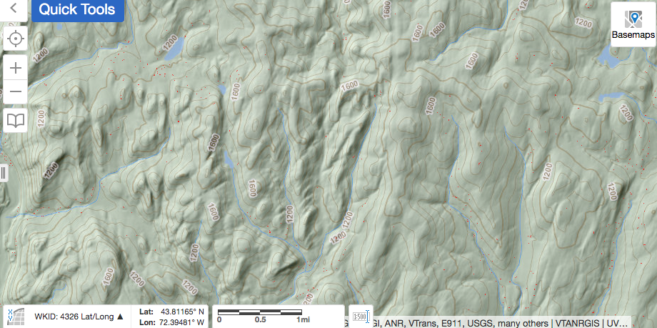 In the next shot, we pan out further, showing some major roads, (Route 132, I-89. etc), and some trails: 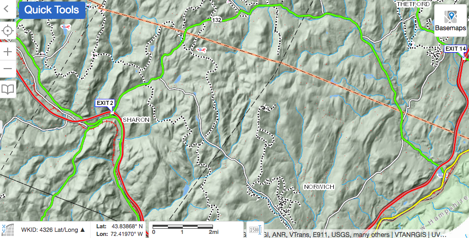 Below is the same area, but seen on the 1855 Windsor County map, showing Sugarhouse Road continuing through to Krivak Road, Sharon. In this view, we can see that families by the name of Wheeler, Hathaway, Smith, Hubbard, Pierce and Roberts had homes in the area where the road is no longer maintained today. I would expect to find remains of the old foundations out there. Some parts may be visible, and some buried. 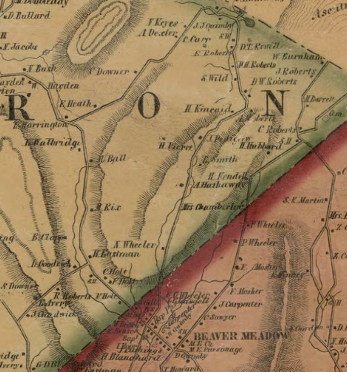 PLANNING THE TRIP: Using the LiDAR maps available at https://maps.vermont.gov/vcgi/html5viewer/?viewer=vtmapviewer, I slowly followed Sugarhouse Road northward, from the start at Beaver Meadow Road, into Sharon. As seen below, starting out from Beaver Meadow Road, heading west towards Sharon, (lower right to upper left), Sugarhouse Road goes to the right (unmarked here). Just east of Sugarhouse Road, we can see the Beaver Meadow, with Mitchell Brook flowing southward, as a thin blue line. Thanks to LiDAR, we can also see an older channel of the brook, which flowed just to the west of today's channel. Beavers, weather, and humans have all participated to alter the flow of the brook here. In the lower right, we can see the mound that is the Beaver Meadow Cemetery. 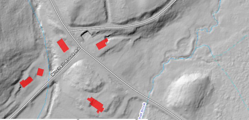 Heading north, up Sugarhouse Road, one would see the beaver meadow to the right. The following is a series of maps showing the progression along Sugarhouse Road: 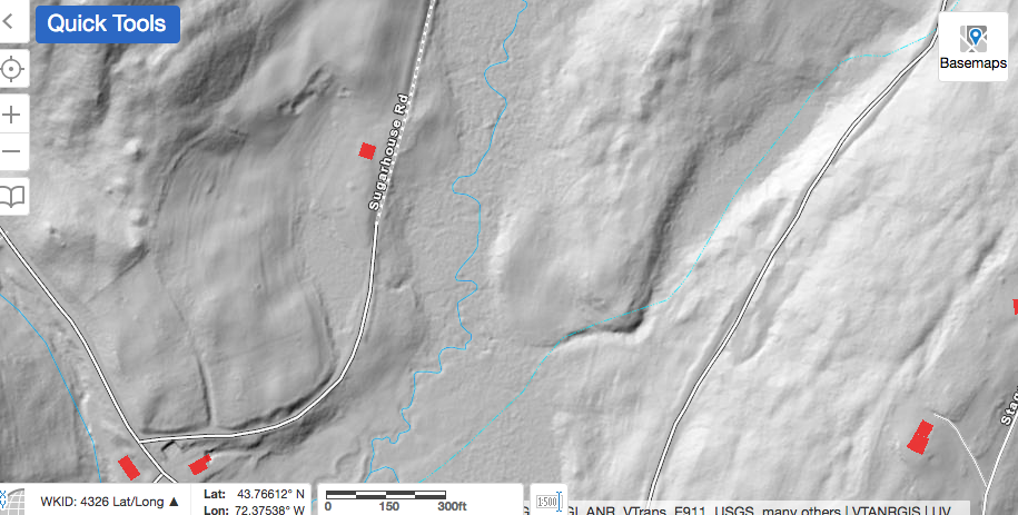 Below is a larger view, showing 2 ponds in the Beaver Meadow, to the east of Sugarhouse Road. 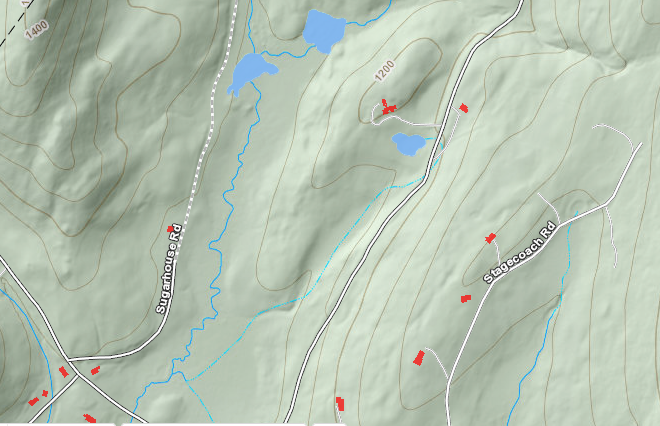 Beyond the ponds, Sugarhouse Road continues, and we see a 1400' hill to the west, while another hill begins to rise to the east. 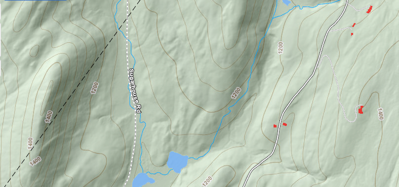 Continuing along Sugarhouse Road, we can see that the wide Beaver Meadow disappears above those two ponds, as the land to the east of Sugarhouse Road climbs to over 1300 feet in elevation. Sugarhouse Road continues, following the narrow valley of the main branch of Mitchell Brook. As seen below, a stream enters from the right, which is where things begin to get interesting. It's at this point that we begin to zoom closer in, and look for details. 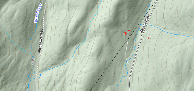 Below, getting closer, we begin to see the features in question, showing up as little shaded "dots'. 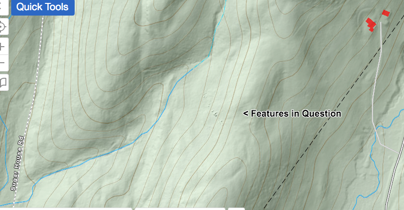 If we were to hike from Sugarhouse Road, inland to these features, we could veer to the east, and climb up, along the channel of the brook. Climbing uphill, and then to the right, we would hopefully find these features and investigate them. Please note, I would want to ask permission of the landowners before hiking up the stream bed. Below, looking more closely, we can see the features in question in the lower right. Also, "What is This?" refers to the interesting looking "half-square". I wonder if its origin might be related to the other features that brought our attention to this spot. Perhaps it represents what is left of some old walls, or could it possibly be of Native American origin? 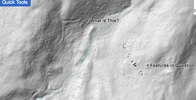 In the book, "A Guide to New England Stone Structures", by Mary Gage and James Gage, (Powwow River Books, Amesbury MA, 2006), reference is made to stone structures and enclosures built by Native Americans. These structures included stone cairns, enclosures, chambers, pedestal boulders, niches, manitou stones, and standing stones. Someone out there has probably visited this site, and knows what it's all about... and I'd love to hear from them! 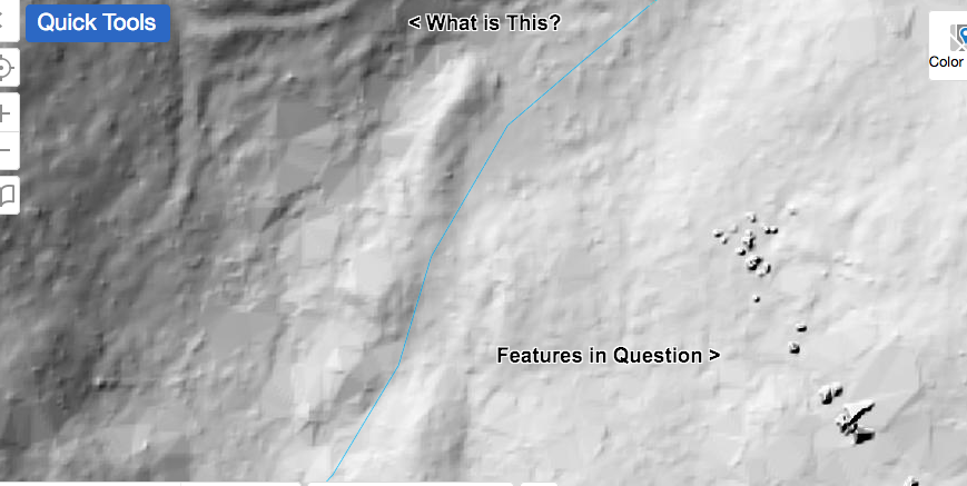 The map below shows the topography well. It appears that the features in question are near the top of a ridge, facing west. 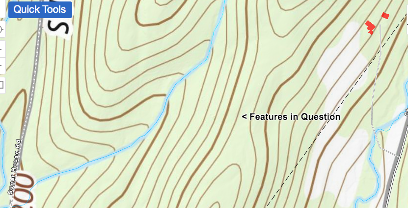 The map below is the same area, but it has an ESRI overlay. By viewing the same scene on different maps, you can sometimes discern patterns and new clues. In the view below, we can see that the features appear to be near the edge of a wooded area. 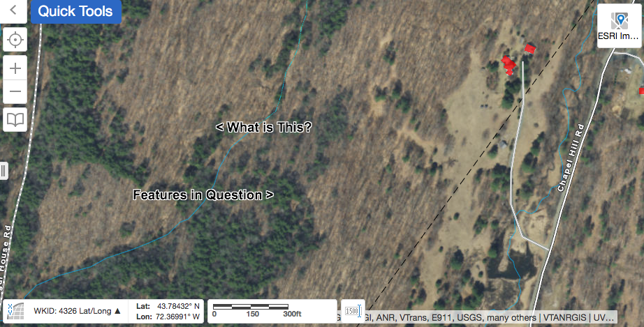 The map below is the same as the one above, except I used the LiDAR imagery slider bar only about half way, so we can see the features in question, along with the ESRI imagery. 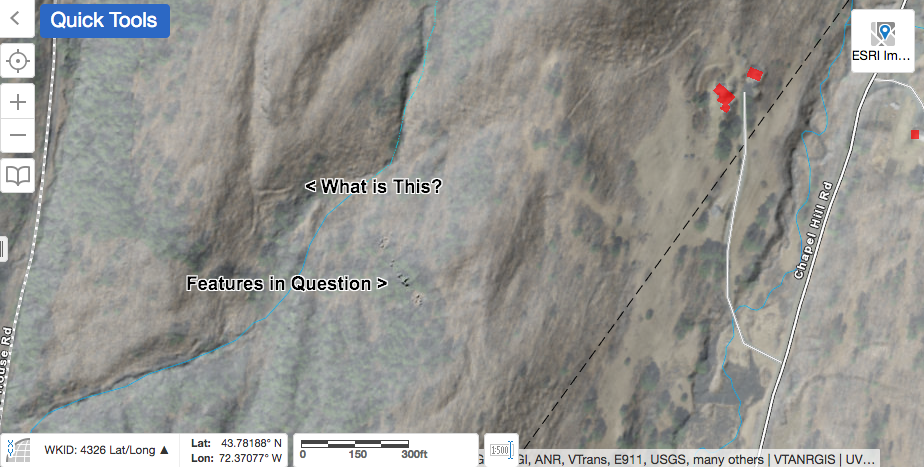 In the final map below, it appears there may be an old path, or logging road coming down on the right. 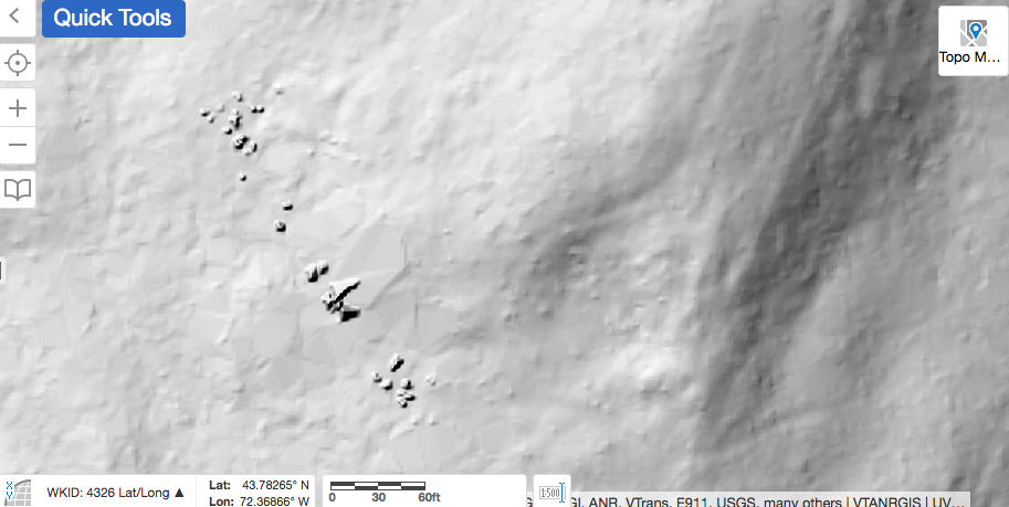 And so, I ask: Do you have any idea what these features are? I am interested in all possibilities, though it would be great to have a definitive answer! Thanks for meandering down Old Roads, Rivers and Rails of the Upper Valley with me, Bob Totz. Comments are always welcome and can be posted at the end of the article. Do you like maps and history of the Upper Valley? New Subscribers and emails are always welcome too. Simply email to: [email protected] Main page at: oldroadsuppervalley.weebly.com Sources: Vermont Center for Geographic Information, Interactive map viewer at: maps.vermont.gov/vcgi/html5viewer/?viewer=vtmapviewer A Guide to New England Stone Structures by Mary Gage and James Gage, 2006, Powwow River Books, Amesbury MA.
12 Comments
Ruth Gaffey
6/14/2020 07:36:35 am
Fascinating! I hope you can get the owners permission to check it out. We have the remains of a stone wall made out of massive rocks that form a corner in our woods presumably from the days when sheep were kept here we think. Hope you can find the answers to your questions!
Kerrie
6/14/2020 08:37:07 am
It looks like some rugged rock outcroppings to me (even gravestones don't show up that prominently on LiDAR) or perhaps an artifact from the imagery processing. But it's certainly worth checking out!
Bob Totz
6/15/2020 07:31:47 am
Yes, I bet they'd be rugged, indeed!
Jim Abbott
6/14/2020 10:25:57 am
I love this stuff, Bob! Looking forward to hearing more about what you’ve learned about this site.
Bob Totz
6/15/2020 07:49:26 am
Thanks, Jim! I love this stuff too, and definitely want to go exploring with you sometime soon, and check out some of those places you mentioned. 6/14/2020 11:50:45 am
This is fascinating! I'd love to head out that way and check it out.
Bob Wagner
6/14/2020 11:57:24 am
Cool find. Can you zoom in any more? It looks like these 'things' are mostly less than 10' but the also seem to be arranged in a line (perhaps the ridge line).
Bob Totz
6/15/2020 07:52:05 am
That was as far as I could zoom in, Bob. I guess we'll have to go out and take a look!
Douglas Shane
6/14/2020 12:39:35 pm
Clearly the "mystery" objects are evidence of an ancient research site inhabited by an advanced alien culture that visited Earth eons ago.
Bob Totz
6/15/2020 07:55:43 am
An alien waste dump?
Bob Totz
7/13/2020 09:11:56 am
Part Two can be found here: Your comment will be posted after it is approved.
Leave a Reply. |
AuthorI'm Bob Totz, retired VT postmaster, and historical geographer ARCHIVES:
October 2021
EXPANDED ARCHIVES: AUGUST 2021 1858 Johnson Map of North America MAY 2021 1795 - "Road Over the Mountain" - Part Two Historic Toll House For Sale 1795 - "Road Over the Mountain" Part One OCTOBER 2020 Finding That Special Peaceful Place AUGUST 2020 Kayaking on the Pompy JULY 2020 Pt. 2: What the Heck Are These Things? JUNE 2020 Bob's Bio... What the Heck Are These Things? Pt. 1 MAY 2020 Stone Walls and Spirits The View APRIL 2020 Sunny Brook Farm Relics: Pt 2. Sunny Brook Farm Relics: Pt 1. MARCH 2020 Signs of Norwich Pt. 2 COVID-19 Tracking Map Centertown and Valleyquest Signs of Norwich Pt. 1 "Imperfect Union" - Book Review Historic Centertown FEBRUARY 2020 King's Hwy Pt. 2 WRJ Museum at Post Mills Airport Chatauguay Vermont The Independent Farmer poem Traveling Along the King's Highway - Lebanon NH JANUARY 2020 Finding Parkhurst Cemetery In Search of Parkhurst Cemetery Affordable Housing The Old Stone Grill Two Rivers Trail-Kmart License and Registration, Please! Prohibition, Murder and Dr. Seuss Peace, Paris, & P.O. DECEMBER 2019 BLOGGER'S LINKS Welcome to Old Roads Love-Quail Hollow fun Dartmouth Cemetery SEPTEMBER 2019 E. Thetford Cemetery JUNE 2019
Taps: Meetinghouse Cemetery 4-Corners Borders Quest Old Iron Gate Stumbling Upon History Sunrise Walk MAY 2019 4 Corners Cemetery Strafford's Abandoned Foundations Art in Old Stonework APRIL 2019 Strafford Tpke Pt 2 Strafford Tpke Pt 1 White River Valley FEBRUARY 2019 Learning from Historic Maps of the Upper Valley Change in Lewiston VT JANUARY 2019 A Vermont Ski Waltz John Ledyard 1773 What is the Upper Valley? DECEMBER 2018 Dartmouth Green Music Video: Sometimes Music Video: Montreal Express Railway Disaster of 1887 |
 RSS Feed
