|
Welcome! Scroll Down for Posts and Archives.
Other Menu Options at Top |
|
|
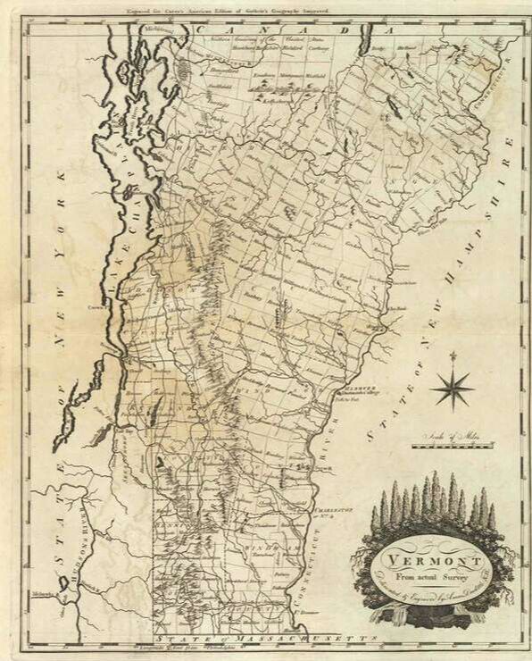 1795 Map of Vermont by Carey The oldest roads in Vermont are shown on the oldest maps of Vermont. However, some parts of the oldest roads have not been maintained in over a century, or more, though some of those portions can still be walked as a trail. Other old roads have been kept up, and some are main thoroughfares today. History and Geography have played important parts in deciding which roads remain. I like to look at the oldest maps, and see the lines that represent the earliest routes used by the first settlers in our region. I then compare them to other maps of varying vintage, and then try to see if I can find and name those old roads today. The best part comes later: walking along a route picked in advance, for its historical character, and looking for clues to history out there, such as features shown on old maps. If you like two hundred-plus year old stone walls, old foundations, cemeteries, ruins of old mills, and ancient witness trees, this can be a good way to find them. 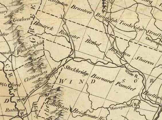 Central portion of 1795 Vermont map by Carey, showing "Road Over the Mountain" from Rutland to Stockbridge. 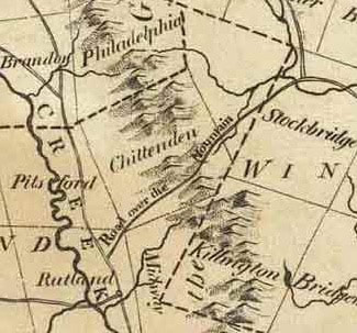 Above, and left, are two insets, from the 1795 map of Vermont by Carey, showing a portion of central Vermont. On the earliest maps, most roads were not identified by name, but occasionally I find one that does have a name, or description, such as: “Road over the Mountain”, seen above, running from Rutland, to Stockbridge. According to the 1795 map, the old road in question headed from Rutland, through the southeast corner of Pittsford, up into Chittenden, where it crossed the Green Mountains and descended into the Tweed and White River Valleys in Pittsfield and Stockbridge. Once in Stockbridge, the Road over the Mountain ended, but if you needed to, you could continue along the shore of the White River in Stockbridge, and follow the trail that would become “Center Turnpike” a few years later, which headed toward Royalton. Maps of the late 1700's are nowhere near as accurate as we are used to seeing. However, they tend to offer clues, including river crossings and township boundaries, that can help in ascertaining where these old routes were, or would be, today. They also offer clues to ruins found along abandoned stretches of old roadways. CAN WE FOLLOW THE OLD ROUTE TODAY? Sometimes, the names of today’s roads offer clues, such as “Mill Road” or “Stage Road”, or something like that, with a historically descriptive name. If you’re looking for an old route, and the road you suspect has a name like that, there’s a good chance you’re on the right road. 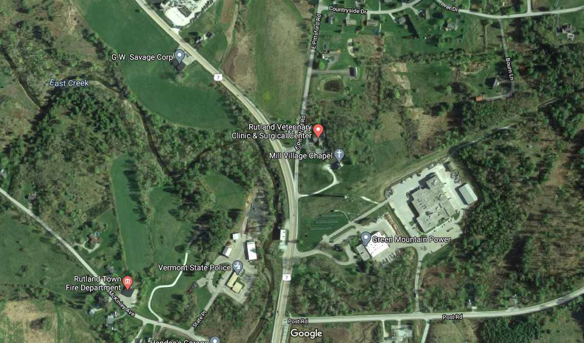 imagery courtesy Google Earth In this particular case, I figured the north-south route that our road jumped off from, was the precursor to today’s Route US 7, and the Road over the Mountain would head east off of that road, north of the city of Rutland, through extreme southeast Pittsford, into Chittenden. If you look on Google Earth, (above), you’ll see there is a road to the east of US Route 7, just north of Rutland, called East Pittsford Road. U.S. 7 North bears to the left. We'll bear right onto East Pittsford Road. There appears to be a veterinary clinic at this point. We'll follow E. Pittsford Road, which goes straight, past Countryside Drive and Russel Drive. The road then crosses East Creek, before turning to the right, to avoid Prospect Hill Road. According to GoogleEarth, there are polo fields on the left, just before that turn. The Google Maps photo below shows the turn at Prospect Hill Road. 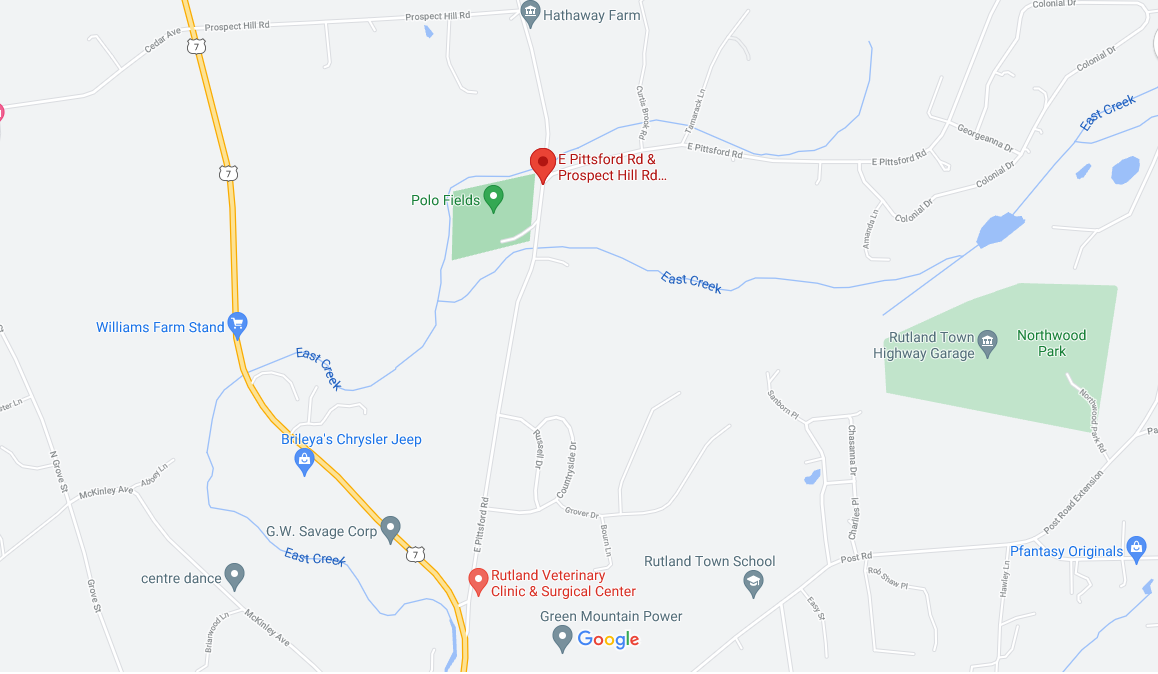 courtesy Google Earth Let’s take a look at this area on the 1869 Beers Atlas: 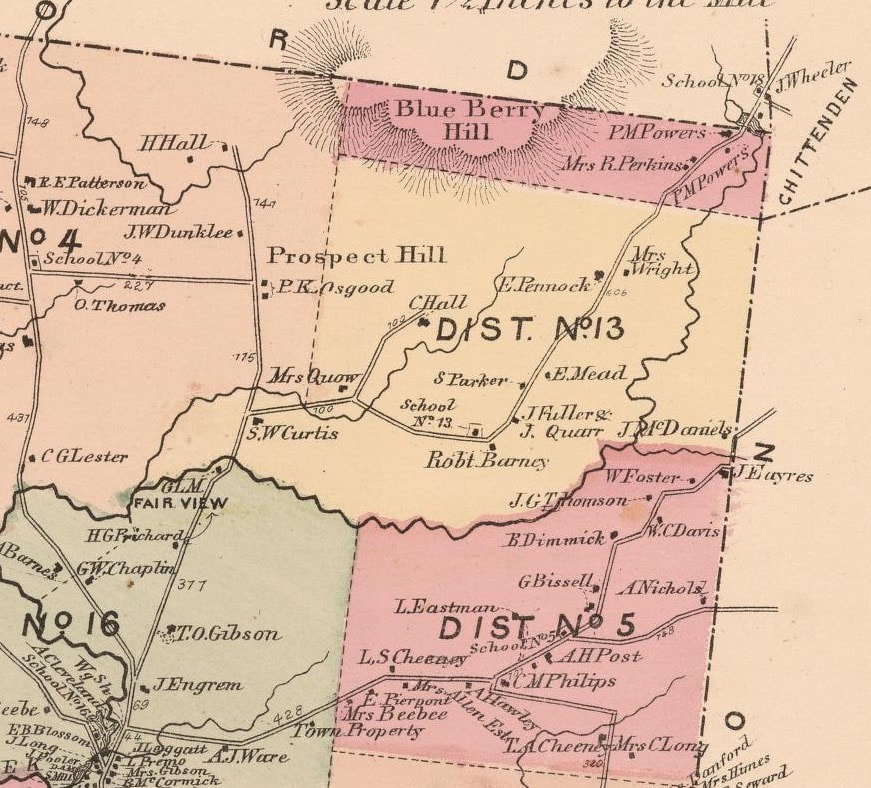 Seventy four years after the 1795 map of Vermont by Carey, the Beers Atlas showed the road network as it had advanced during the pre-motor vehicle era. The atlas shows the farms and homesteads along the route. Beginning in District 16, and crossing into District 13, J. Engram lived near the turn from Route 7 onto East Pittsford Road, and T. O. Gibson was not far, up on the right. At the turn near Prospect Hill Road, the farm was owned by S. W. Curtis. Not far from there, you would bear right at the home of Mrs. Quow. I really love how the mid-nineteenth century cartographers were able to incorporate the names of the property owners into their artwork. School number 13 would have been on your left, as you pass the place owned by Robert Barney. At Robert Barney’s place the road turns and heads northeast, past more farms, toward the village of East Pittsford, just after the Perkins’ and Powers’ places, in the extreme southeast corner of Pittsford township. School number 18 can also be seen in East Pittsford, just before heading into Chittenden, by J. Wheeler's place. Here is a look at the bigger picture, below, also from Beers’ 1869 Atlas: The road crosses the extreme southeast portion of Pittsford, before heading up into Chittenden village, in the southwest portion of Chittenden township. Notice Chittenden Pond in the southeast portion. 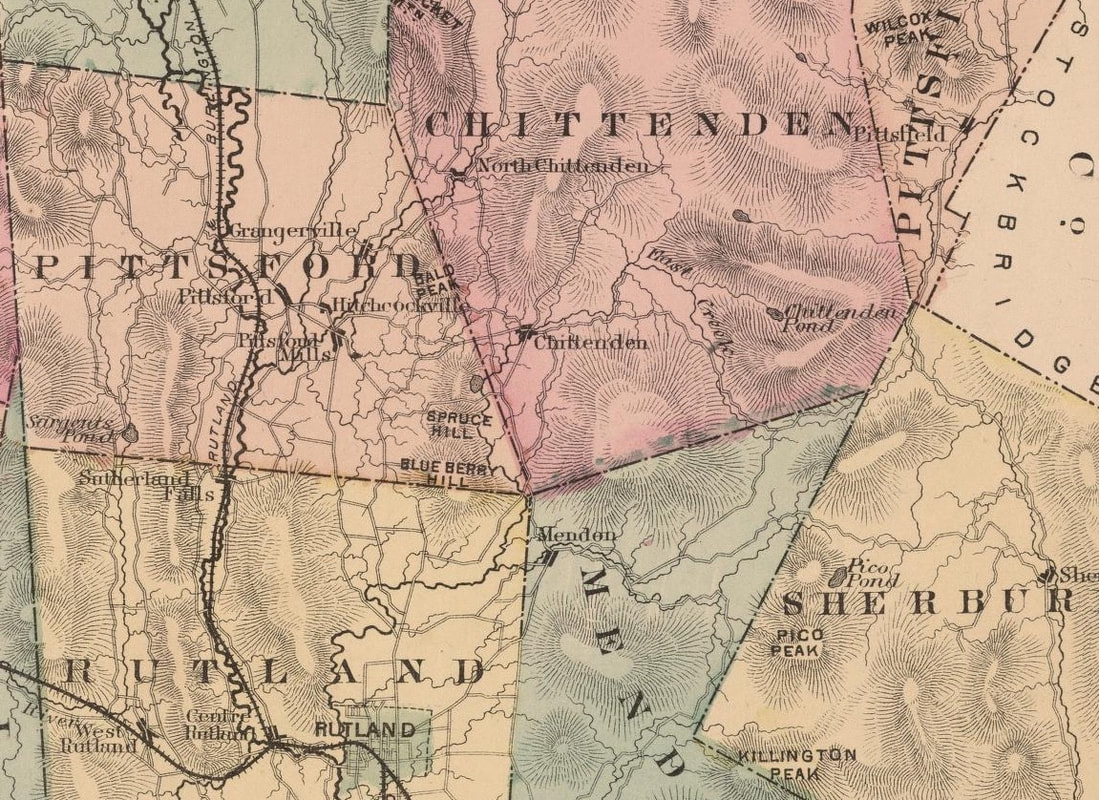 Chittenden pond was eventually dammed to create Chittenden Reservoir. Here is a link to an article with photos, about constructing the Chittenden Reservoir, from 1900 to 1909: https://www.vpr.org/post/historical-photos-show-arduous-construction-chittenden-reservoir#stream/0 Below is an inset from an 1817 map, from an Atlas by Samuel Lewis, which also shows the "Road Over the Mountain". 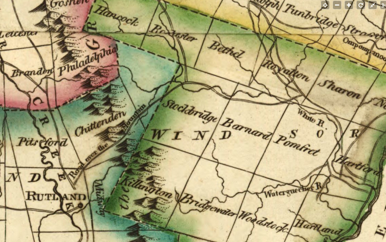 Inset from the 1817 Samuel Lewis Atlas Here is one more look at the area from Rutland to East Pittsford, from the 1854 map of Rutland County by Scott: 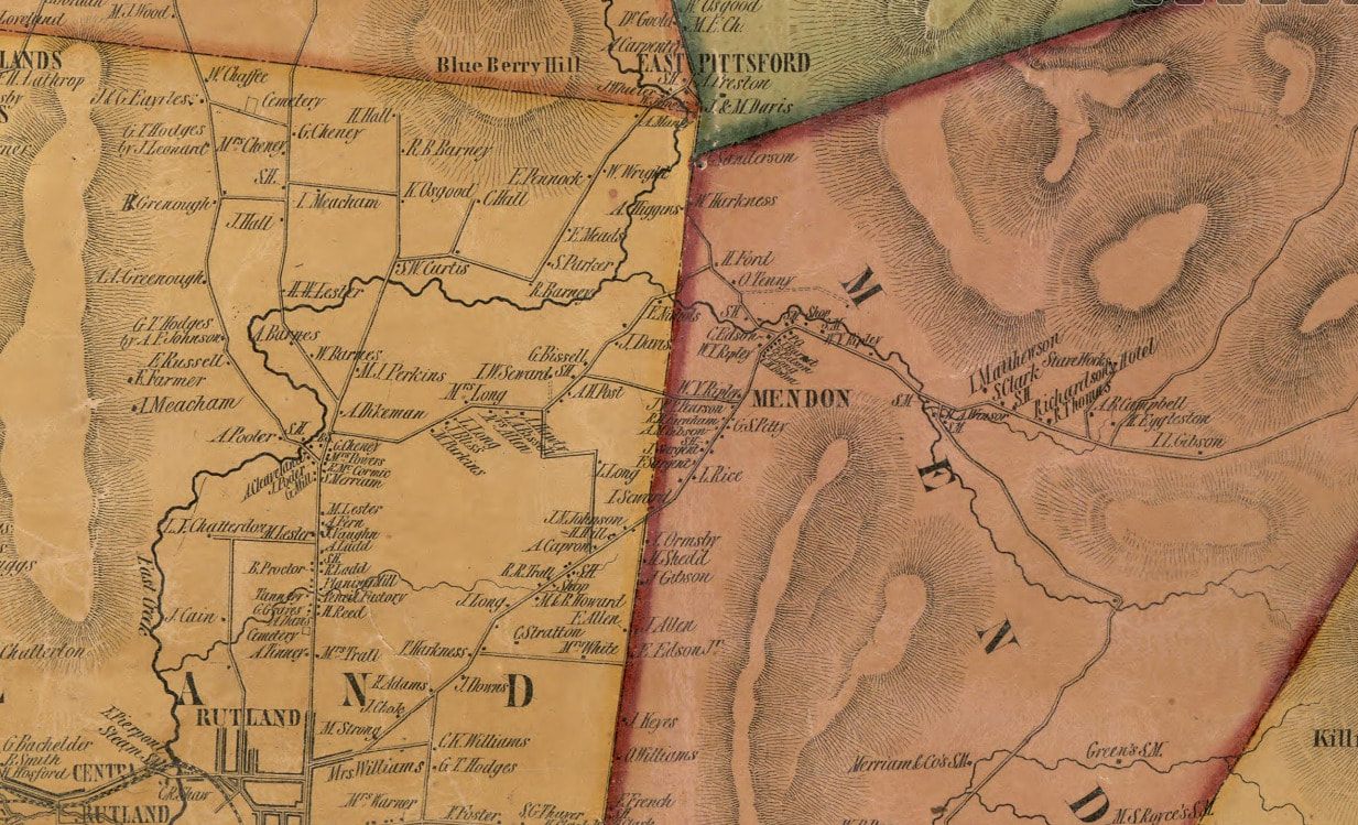 Inset from Scott's 1854 map of Rutland County, Vermont Inset from Scott's 1854 map of Rutland County, Vermont END of PART ONE In part two we'll continue our journey along "The Road Over the Mountain". SOURCES: 1795 Vermont Map by Carey: http://vtroads.com/downloads/vt_1795_CareyWEBdown.jpg GoogleEarth imagery Beers Atlas of Vermont, Rutland County, 1869. www.davidrumsey.com/luna/servlet/workspace/handleMediaPlayer;JSESSIONID=30728d37-3c5d-492e-a353-da3e61cd3115?lunaMediaId=RUMSEY~8~1~226869~5506969 1817 Samuel Lewis Atlas map of Vermont: www.loc.gov/resource/g3750.ct000097/?r=0.233,0.633,0.313,0.139,0 1854 Map of Rutland County by Scott: www.loc.gov/resource/g3753r.la001190/?r=0.523,0.48,0.242,0.107,0
4 Comments
Doug Eisler
7/8/2021 08:22:06 pm
Bill! Funny to run into you here... I love this website.
Ted Jerome
5/26/2021 03:42:42 pm
Another great blog entry, Bob!
Bob Totz
5/27/2021 07:00:28 am
Thanks, Ted! Your comment will be posted after it is approved.
Leave a Reply. |
AuthorI'm Bob Totz, retired VT postmaster, and historical geographer ARCHIVES:
October 2021
EXPANDED ARCHIVES: AUGUST 2021 1858 Johnson Map of North America MAY 2021 1795 - "Road Over the Mountain" - Part Two Historic Toll House For Sale 1795 - "Road Over the Mountain" Part One OCTOBER 2020 Finding That Special Peaceful Place AUGUST 2020 Kayaking on the Pompy JULY 2020 Pt. 2: What the Heck Are These Things? JUNE 2020 Bob's Bio... What the Heck Are These Things? Pt. 1 MAY 2020 Stone Walls and Spirits The View APRIL 2020 Sunny Brook Farm Relics: Pt 2. Sunny Brook Farm Relics: Pt 1. MARCH 2020 Signs of Norwich Pt. 2 COVID-19 Tracking Map Centertown and Valleyquest Signs of Norwich Pt. 1 "Imperfect Union" - Book Review Historic Centertown FEBRUARY 2020 King's Hwy Pt. 2 WRJ Museum at Post Mills Airport Chatauguay Vermont The Independent Farmer poem Traveling Along the King's Highway - Lebanon NH JANUARY 2020 Finding Parkhurst Cemetery In Search of Parkhurst Cemetery Affordable Housing The Old Stone Grill Two Rivers Trail-Kmart License and Registration, Please! Prohibition, Murder and Dr. Seuss Peace, Paris, & P.O. DECEMBER 2019 BLOGGER'S LINKS Welcome to Old Roads Love-Quail Hollow fun Dartmouth Cemetery SEPTEMBER 2019 E. Thetford Cemetery JUNE 2019
Taps: Meetinghouse Cemetery 4-Corners Borders Quest Old Iron Gate Stumbling Upon History Sunrise Walk MAY 2019 4 Corners Cemetery Strafford's Abandoned Foundations Art in Old Stonework APRIL 2019 Strafford Tpke Pt 2 Strafford Tpke Pt 1 White River Valley FEBRUARY 2019 Learning from Historic Maps of the Upper Valley Change in Lewiston VT JANUARY 2019 A Vermont Ski Waltz John Ledyard 1773 What is the Upper Valley? DECEMBER 2018 Dartmouth Green Music Video: Sometimes Music Video: Montreal Express Railway Disaster of 1887 |
 RSS Feed
