|
Welcome! Scroll Down for Posts and Archives.
Other Menu Options at Top |
|
|
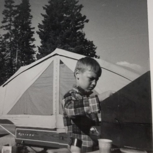 Cooking Breakfast at Cedar Breaks, Utah, 1968 Cooking Breakfast at Cedar Breaks, Utah, 1968 If you've ever been asked for a "Bio" of yourself, you'll find it to be an interesting project! Here is what I wrote today, at age 60, trying to be concise, yet complete: BIOGRAPHY of BOB TOTZ I was born 1n 1960 and grew up in Wallingford, Connecticut, about 15 miles north of Pepe's Pizzeria, I mean, New Haven. CAMPING AND MAPS Starting around 1964, my family used to go camping in the summers, first with a tent, and then with a tent-trailer, or pop-up camper. Ours was a Nimrod, Riviera model, which my father modified in order to add a bed and increased storage. At first, our camping trips were confined to the shore of Connecticut, and then in subsequent years we began to travel farther, first in New England, then Pennsylvania in 1966, Florida in ’67, and in 1968 we took a five week journey across the USA, to California and back, exploring the National Parks with a Golden Eagle Pass. A 1963 Dodge Dart was our key to adventure, and that little car never failed us. While traveling around the country, I often was in the front seat, in between my parents. While my sisters in the back seat reviewed the latest Archie comics, and other intellectual material of the day, I liked to look at the road maps, (which were given away for free at every service station), and see what interesting attractions might be ahead of us. Then I would watch, and compare what I saw from the car window, with what I had seen on the maps. I thought this was pretty cool! And that is where my love of maps, (Cartography), Geography and History began. UConn - 1978 - 1983 At the University of Connecticut I began my studies in the school of engineering, but soon transferred to the Geography department in the College of Liberal Arts and Sciences. There I took almost all the geography and cartography courses I could find, including Air Photo Interpretation, Satellite Imagery, Historical Geography, Map Interpretation, and many others. Move to Upper Valley - 1984 It seems like I have always loved to hike on trails and old roads in the woods. In 1984 I moved to the Upper Valley for a position in digital mapping. At that time, just out of college, I had been living outside of Washington DC, where I was waiting to hear from the Defense Mapping Agency about a position I was planning to take. However, a job offer in the Upper Valley, where hiking trails and fresh air abound, lured me away from the big city. The job in the Upper Valley paid a lot less than the job in DC, and it was a lot colder and snowier in the winter too, but the move was a decision I have never regretted. U. S. Postal Service, 1987 - 2016 After a few years in digital mapping and surveying, I took a job with the Postal Service in White River Junchtion. Within a year or so, I took a job in Quality Control, and later in Statistical Programs, in the Department of Finance. In Statistical Programs, I used to drive all over Vermont, visiting Post Offices large and small, conducting surveys on “live mail”. This gave me the opportunity to explore Vermont's hamlets, villages, towns and cities, mapping out my routes in advance. With this job I traveled from White River to Brattleboro, Bennington, Derby Line, Burlington, Fair Haven, and lots of little towns in between. While traveling around the state for the USPS Department of Finance, I found that I really liked the atmosphere in small town post offices, and that a postmaster’s position was something I might aspire to. In small town post offices, there seemed to always be a generally happy attitude among the postal workers, and among the regular customers who came to the window in the morning. In 1991 I married Jill, the love of my life, and we have lived in the same small cabin in Norwich for the past 30 years. In September 1991 I took an “Officer in Charge” assignment at the Tunbridge Vermont Post Office. What a great place! I really loved the job, and the community. Every morning, while I was sorting mail, Roger, the rural carrier would light his pipe and sort the mail to his route. At the same time, the “regulars” would come into the lobby and sit down and chat, while waiting for their mail. The door to the post office work area would be left open so that customers could chat with Roger, and me too, and we would be part of the conversation. I knew that technically the door to the lobby was supposed to be closed, (and locked), but I could see that this was an old tradition and that it was probably pretty safe to keep that door open in Tunbridge Vermont, at 9:00 in the morning, with all those good people there to help in the remote case of an emergency! The position of “OIC” or “Acting Postmaster” in Tunbridge Vermont lasted about four months, after which I returned to my position in the Finance Department in White River. This was January 1992, and soon the USPS was involved in an administrative reorganization, which resulted in my position being changed, and re-posted with different hours and days off, which did not appeal to me. I had decided I wanted to become a postmaster by this point anyway, and I transferred to the Norwich Vermont Post Office for more experience, less travel, and daytime work hours. After about a year and a half of working in the Norwich Post Office, I became Postmaster of Post Mills Vermont, where I worked as part of that unique community for over 19 years. I loved that job, and I still am in love with that community, and miss the great people I met there. The Post Office was, and still is, in the back of Baker’s general store, adjacent to the deli, and about a half mile from Lake Fairlee. I enjoyed learning about the history of the Post Mills area from local folks who grew up there, and had ancestors who had also grown up there. My golden retriever, Mickey used to help wait on customers, and at lunch we'd go for a walk and maybe a swim too. I could certainly write a book about my many experiences there over the years....hmmm...! In 2013, the Postmaster's job in Post Mills was eliminated however, and I was lucky to get the position of Postmaster of Sharon Vermont for my last three years with the Postal Service, before retiring in 2016. I met more great folks in Sharon, and have good memories of my three years there. Amateur Music Career I started playing harmonica at age seven, while camping. Both my father and grandfather were harmoonica players, so I had good teachers at a young age. At ten, I started taking trumpet lessons in school; actually it was a cornet. Also at age 10, I sang my first solo, "I'm getting nuttin' for Christmas" in a school concert. At about age fourteen I received a guitar for Christmas and learned how to play it from my best friend, Jamie Daly. From 1995 - 2013 I was a choir member at Saint Anthony’s catholic church in White River Junction, and from 2006 - 2013 I was director of the choir for the 10:30 AM Sunday mass. It was during this time that I began to compose music for choir, and in later years, for my own band. Highlights were our annual midnight mass at Christmas eve, which included brass instruments and organ. From 2005 - 2009 I was a member of the Upper Valley Community Band, and the Lyme NH Town Band, playing trumpet. In 2007, I had the honor of going to Joigny, France with the Hanover-Joigny Festival Band, where I played first trumpet for a five-nation, weekend band festival of “sister cities” from Britain, Germany, Italy, France and the USA. In 2012 I helped organize the acoustic band, “Out on a Limb”, which I left in 2017. The band still plays, and I occasionally “sit in” with them. 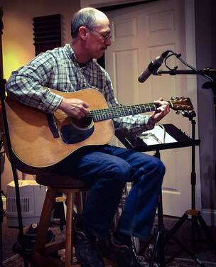 Recording Session May 2017 Recording Session May 2017 These days I play occasional musical engagements, with guitar, harmonica and vocals. I'm also a composer of folk songs, and my specialty is historical tales, such as “Morey Made the Magic” about Samuel Morey, resident of Fairlee, Vermont, inventor of the steamboat; and “Montreal Express” about the February 1887 Rail disaster over the White River in West Hartford Vermont. Old Roads, Rivers and Rails of the Upper Valley
In December 2018 I started my blog, “Old Roads, Rivers and Rails”, after publishing the music video / micro-documentary “Montreal Express”, where I combined my interests in History, Music, Photography, Geography, and Transportation. Shortly thereafter, I joined dailyUV.com as a paid blogger. Blogging was new to me, but writing was not, and I soon rekindled my love of maps, old roads, geography, hiking and history, as well as photography, applied to the Upper Valley of Vermont and New Hampshire. When the paid blogging platform went on hiatus in December 2019, I started the “Old Roads, Rivers and Rails of the Upper Valley" blog and website, for the fun of it. It can be found at: oldroadsuppervalley.weebly.com. Many of the stories I published in 2019 disappeared since the paid blogging site was discontinued. However, in ancticipation of that event, I spent a good portion of last December re-producing some of the more popular stories on the Old Roads, Rivers and Rails of the Upper Valley website archives. From looking at road maps on family summer trips in the 60's, to studying cartography at UConn in the 70's, to creating digital Zip Code boundary maps, and surveying in the 80's, to small town Postmaster in the 90's, and choir director in the 2000's, and now blogging about maps and geography, it's been a fun ride, which I'm thrilled to continue, and post about here at oldroadsuppervalley.weebly.com Thanks for joining me for the occasional hike along the old roads! - Bob Totz, Norwich VT June 27, 2020
4 Comments
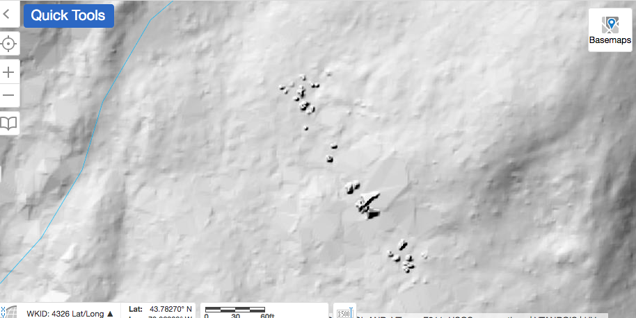 Do you see the features in the center of the LiDAR map above? I could use some help figuring out what they are! 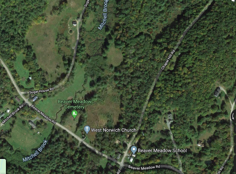 Courtesy Google Earth While preparing for a walk out Sugarhouse Road, in West Norwich, VT, I decided to look for anything interesting I might find out there, like ruins of old foundations, along the way, using LiDAR maps. That's when I found these interesting features, seen in the top photo above. My first guess is that they are very large boulders, or steep outcroppings, but I'm also wondering if they could have been made by humans. I have heard rumors of Native American ruins in that general area, though I've never been told exactly where, or what they may be. Researching with LiDAR maps is a good way to learn about an area you are about to explore. These maps can show geologic and man-made features, such as stone walls and foundations, mill sites, etc. Below is a much wider map of the area in question, showing only the LiDAR information; no overlays. You can see that you get a really good look at surface contours. 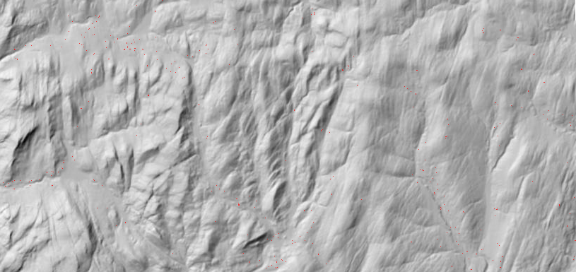 Now we'll add an overlay with some topographic lines and water features, below: 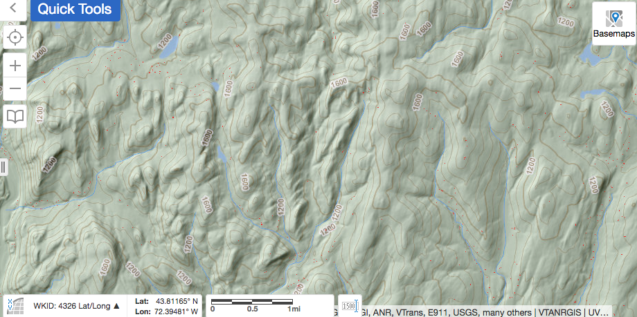 In the next shot, we pan out further, showing some major roads, (Route 132, I-89. etc), and some trails: 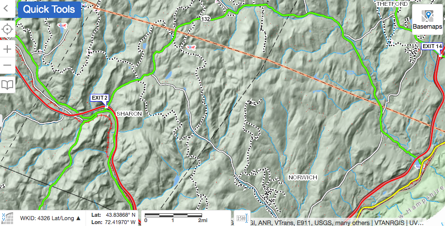 Below is the same area, but seen on the 1855 Windsor County map, showing Sugarhouse Road continuing through to Krivak Road, Sharon. In this view, we can see that families by the name of Wheeler, Hathaway, Smith, Hubbard, Pierce and Roberts had homes in the area where the road is no longer maintained today. I would expect to find remains of the old foundations out there. Some parts may be visible, and some buried. 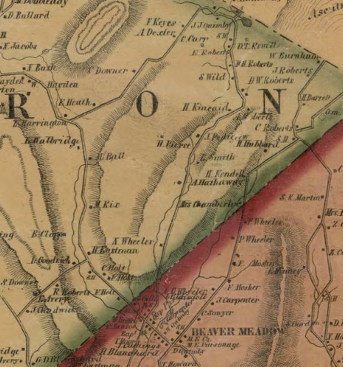 PLANNING THE TRIP: Using the LiDAR maps available at https://maps.vermont.gov/vcgi/html5viewer/?viewer=vtmapviewer, I slowly followed Sugarhouse Road northward, from the start at Beaver Meadow Road, into Sharon. As seen below, starting out from Beaver Meadow Road, heading west towards Sharon, (lower right to upper left), Sugarhouse Road goes to the right (unmarked here). Just east of Sugarhouse Road, we can see the Beaver Meadow, with Mitchell Brook flowing southward, as a thin blue line. Thanks to LiDAR, we can also see an older channel of the brook, which flowed just to the west of today's channel. Beavers, weather, and humans have all participated to alter the flow of the brook here. In the lower right, we can see the mound that is the Beaver Meadow Cemetery. 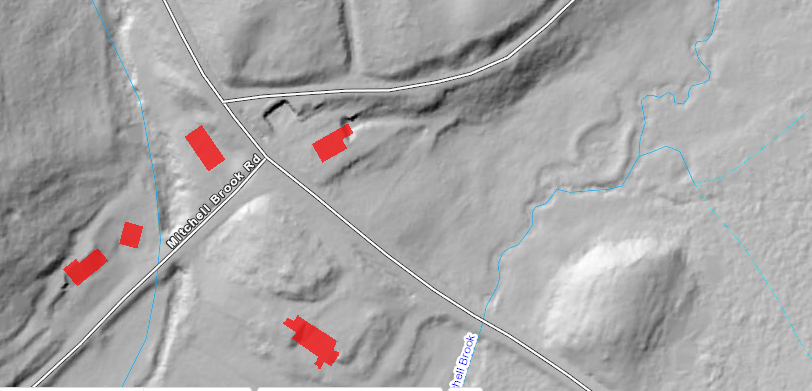 Heading north, up Sugarhouse Road, one would see the beaver meadow to the right. The following is a series of maps showing the progression along Sugarhouse Road: 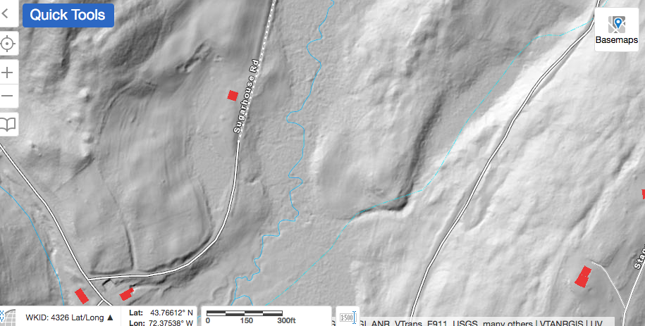 Below is a larger view, showing 2 ponds in the Beaver Meadow, to the east of Sugarhouse Road. 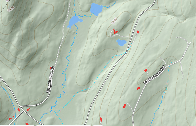 Beyond the ponds, Sugarhouse Road continues, and we see a 1400' hill to the west, while another hill begins to rise to the east. 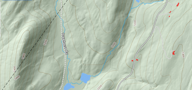 Continuing along Sugarhouse Road, we can see that the wide Beaver Meadow disappears above those two ponds, as the land to the east of Sugarhouse Road climbs to over 1300 feet in elevation. Sugarhouse Road continues, following the narrow valley of the main branch of Mitchell Brook. As seen below, a stream enters from the right, which is where things begin to get interesting. It's at this point that we begin to zoom closer in, and look for details. 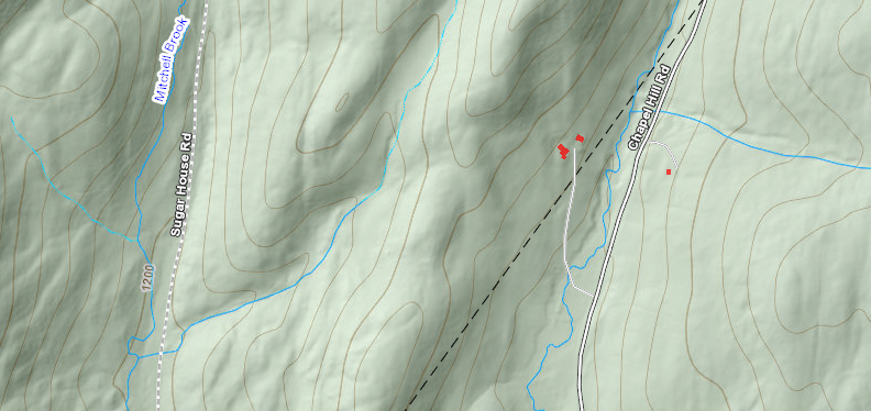 Below, getting closer, we begin to see the features in question, showing up as little shaded "dots'. 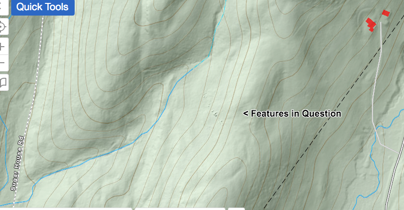 If we were to hike from Sugarhouse Road, inland to these features, we could veer to the east, and climb up, along the channel of the brook. Climbing uphill, and then to the right, we would hopefully find these features and investigate them. Please note, I would want to ask permission of the landowners before hiking up the stream bed. Below, looking more closely, we can see the features in question in the lower right. Also, "What is This?" refers to the interesting looking "half-square". I wonder if its origin might be related to the other features that brought our attention to this spot. Perhaps it represents what is left of some old walls, or could it possibly be of Native American origin? 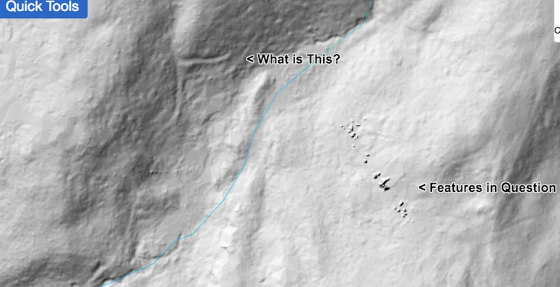 In the book, "A Guide to New England Stone Structures", by Mary Gage and James Gage, (Powwow River Books, Amesbury MA, 2006), reference is made to stone structures and enclosures built by Native Americans. These structures included stone cairns, enclosures, chambers, pedestal boulders, niches, manitou stones, and standing stones. Someone out there has probably visited this site, and knows what it's all about... and I'd love to hear from them! 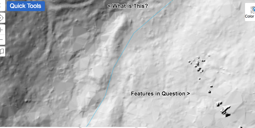 The map below shows the topography well. It appears that the features in question are near the top of a ridge, facing west. 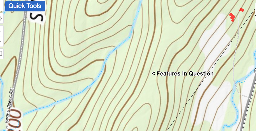 The map below is the same area, but it has an ESRI overlay. By viewing the same scene on different maps, you can sometimes discern patterns and new clues. In the view below, we can see that the features appear to be near the edge of a wooded area. 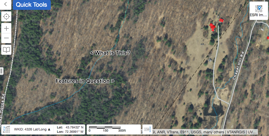 The map below is the same as the one above, except I used the LiDAR imagery slider bar only about half way, so we can see the features in question, along with the ESRI imagery. 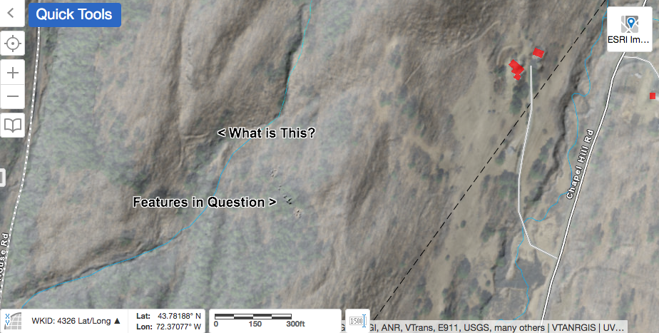 In the final map below, it appears there may be an old path, or logging road coming down on the right. 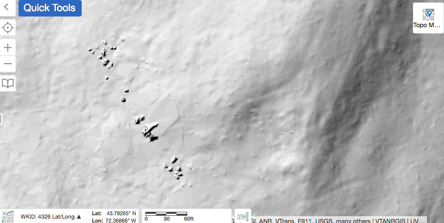 And so, I ask: Do you have any idea what these features are? I am interested in all possibilities, though it would be great to have a definitive answer! Thanks for meandering down Old Roads, Rivers and Rails of the Upper Valley with me, Bob Totz. Comments are always welcome and can be posted at the end of the article. Do you like maps and history of the Upper Valley? New Subscribers and emails are always welcome too. Simply email to: [email protected] Main page at: oldroadsuppervalley.weebly.com Sources: Vermont Center for Geographic Information, Interactive map viewer at: maps.vermont.gov/vcgi/html5viewer/?viewer=vtmapviewer A Guide to New England Stone Structures by Mary Gage and James Gage, 2006, Powwow River Books, Amesbury MA.
|
AuthorI'm Bob Totz, retired VT postmaster, and historical geographer ARCHIVES:
October 2021
EXPANDED ARCHIVES: AUGUST 2021 1858 Johnson Map of North America MAY 2021 1795 - "Road Over the Mountain" - Part Two Historic Toll House For Sale 1795 - "Road Over the Mountain" Part One OCTOBER 2020 Finding That Special Peaceful Place AUGUST 2020 Kayaking on the Pompy JULY 2020 Pt. 2: What the Heck Are These Things? JUNE 2020 Bob's Bio... What the Heck Are These Things? Pt. 1 MAY 2020 Stone Walls and Spirits The View APRIL 2020 Sunny Brook Farm Relics: Pt 2. Sunny Brook Farm Relics: Pt 1. MARCH 2020 Signs of Norwich Pt. 2 COVID-19 Tracking Map Centertown and Valleyquest Signs of Norwich Pt. 1 "Imperfect Union" - Book Review Historic Centertown FEBRUARY 2020 King's Hwy Pt. 2 WRJ Museum at Post Mills Airport Chatauguay Vermont The Independent Farmer poem Traveling Along the King's Highway - Lebanon NH JANUARY 2020 Finding Parkhurst Cemetery In Search of Parkhurst Cemetery Affordable Housing The Old Stone Grill Two Rivers Trail-Kmart License and Registration, Please! Prohibition, Murder and Dr. Seuss Peace, Paris, & P.O. DECEMBER 2019 BLOGGER'S LINKS Welcome to Old Roads Love-Quail Hollow fun Dartmouth Cemetery SEPTEMBER 2019 E. Thetford Cemetery JUNE 2019
Taps: Meetinghouse Cemetery 4-Corners Borders Quest Old Iron Gate Stumbling Upon History Sunrise Walk MAY 2019 4 Corners Cemetery Strafford's Abandoned Foundations Art in Old Stonework APRIL 2019 Strafford Tpke Pt 2 Strafford Tpke Pt 1 White River Valley FEBRUARY 2019 Learning from Historic Maps of the Upper Valley Change in Lewiston VT JANUARY 2019 A Vermont Ski Waltz John Ledyard 1773 What is the Upper Valley? DECEMBER 2018 Dartmouth Green Music Video: Sometimes Music Video: Montreal Express Railway Disaster of 1887 |
 RSS Feed
