|
Welcome! Scroll Down for Posts and Archives.
Other Menu Options at Top |
|
|
|
The Old King's Highway shows up in Lebanon, NH, and Hartford and Pomfret Vermont, among other places. I was told by an old timer once, that "The King's Highway ran to Montreal via Montpelier". I'm not quite sure that was true, but in any case, I decided to attempt to locate the mythical road, or at least map out a route on some of Vermont's oldest roads that are still in use today. 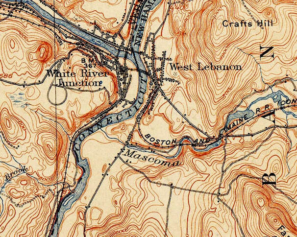 Map Image from 1908 USGS 15 minute Series Hanover Quadrangle. The view above, and inset below, show Nutt Lane in White River Junction, Vermont, where it heads down to the shore of the Connecticut River, circa 1908. 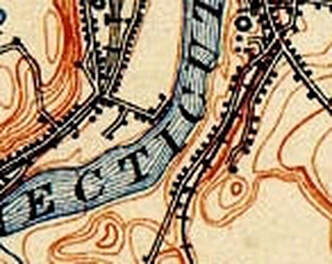 In the first post on this subject, we explored the Old King's Highway in Lebanon, which wound around Farnum Hill, and appeared to end up by the Connecticut River, about where Airport Road comes down to Route 12A today. I had a nice chat with an older gentleman who grew up in West Lebanon, New Hampshire, about what route folks would take, to get from the King's Highway in Lebanon to the King's Highway in White River Junction. He suggested folks forded the Connecticut River a bit south of Lyman Point, which is where we cross into White River Junction on US Route 4 today. The first bridge over the Connecticut River from West Lebanon was opened around 1804. It was a toll bridge owned by Elias Lyman III. For a time, before the bridge existed, there could have been a ferry available. The gentleman I was talking to mentioned there was a depression between two houses along the Connecticut River on Route 12A, that may have been where folks used to cross the river, before the toll bridge opened. The spot happened to be directly across the Connecticut River from what is now the end of Nutt Lane in White River Junction. "S. Nutt" is shown at the end of the road by the shore. 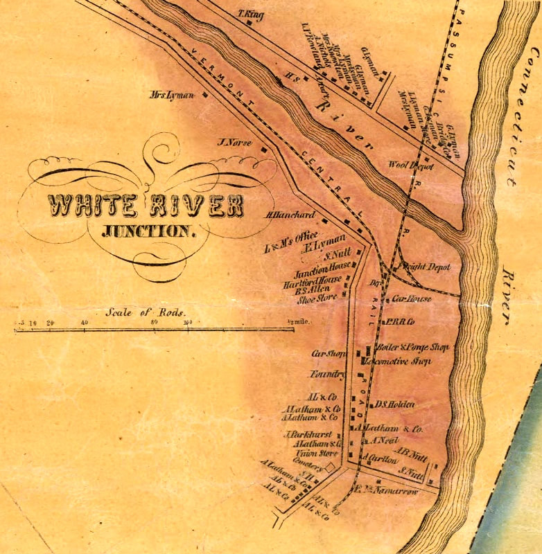 White River Junction, circa 1855, During the Railroad Boom. Nutt Lane, St. Anthony's Cemetery, and the Railroad tracks are all still there today. The intersection with what is today, Sykes Mountain Ave appears to be shown, at the very bottom, just below the last "A. L. & Co." buildings. Close up below. 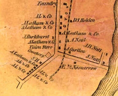 Nutt Lane was probably named after Samuel Nutt. He owned the Junction House Hotel, which opened in 1850. Samuel Nutt was an entrepreneur, who took advantage of the new railroad industry in White River Junction, and who also had a boating business, beginning around 1830. Samuel Nutt was also the first Postmaster of White River Junction. I'm guessing Sykes Mountain Ave would have been the route the earliest travelers would have hiked or rode up from the Nutt Lane area to King's HIghway. In the map below, from 1855, you can see a road running from the lower right, diagonally, northwest. This road appears to be "Sykes Moutain Ave" of today, or an earlier road in approximately that area. Climbing up that hill, in 1855, one would come to a schoolhouse at a four corners. Here is a closer look. The four corners is circled in light pencil, near the Pinneo Farm, which is approximately where the V.A. Hospital stands today. 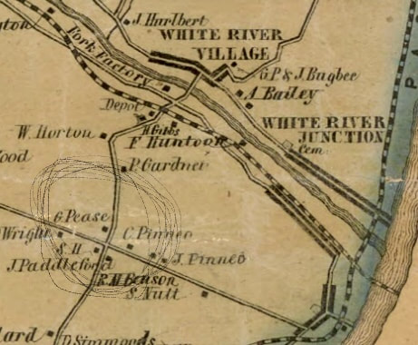 This appears to me to be the corner of what we now call the V.A. Cutoff Road, Route 5, and where King's Highway used to connect. The V.A. Cutoff Road is seen running north, and leads down across the train tracks, to the (old) depot, River Road, and the bridge to Hartford Village, known in 1855 as "White River Village". North Hartland Road comes in from the south, and is shown taking a hard right, which I believe is the predecessor to Sykes Mountain Avenue, as it heads down to White River Junction. King's Highway heads northwest, past Wright's place. ______________________________________ Here is a quote from David Brown recorded by the Hartford Agricultural Oral History Project, June 12, 2012: "This farm actually bordered the road that was in town’s history as King’s Highway that ran from Boston to Montreal. It was a stagecoach road. And it went up over part of our farm – Hurricane Hill – to the center of town, which was the original center of the Town of Hartford and then on to Quechee and Woodstock and headed to Montreal... ...The Veteran’s Hospital, which is adjacent to us to the north, when it was built in 1938, there was discussion that it was built on the Pinneo Farm... ...The area I’m referring to is [Beers Map] – okay, right here you’re coming up from White River and there is what used to be Four Corners right behind the food stop. Now it’s referred to as the VA Cutoff that runs down here to the village of Hartford. But in those days it was the Four Corners. And there was also a district school, District 14 I think, the Wright school. " _________________________ Below is a view of the same area, 53 years later, from 1908. Climbing up Sykes Mountain Avenue in 1908 would bring you up the hill, and into the Vermont State Fairgrounds, where the racetrack is visible. The Vermont State Fair was an annual event held in that area from the mid-1800's until 1928. The Twin State Airport occupied the area from 1929 - 1950, and was visited by Amelia Earhart in 1933. 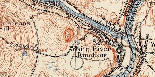 1908 View of White River Junction, Showing the Fairgrounds. On the 1908 map above, on the left, center, we can still see the schoolhouse at the Four Corners of the VA Cutoff Road, and North Hartland Road. And King's Highway is still connected, about where the Carriage Shed is today, perhaps. At this point in time, there was no road called Route 5. Below is a VTrans map of the same area from 1931. At this point the King's Highway still went through, from the looks of this map. I recently read that there was a train spur that went up to the Fairgrounds from the White River Junction and that the route they used is today the section of Route 5, that leads up to Sykes Avenue from the Junction. 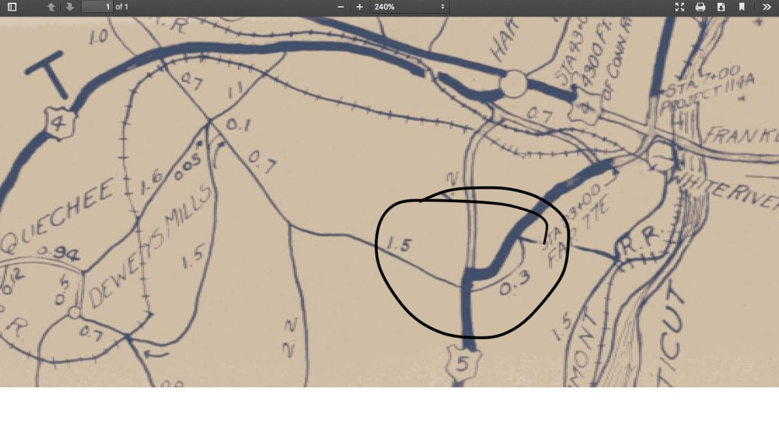 In the 1931 Vtrans map above, you can also see the soon to be dismantled Woodstock Railroad line, heading toward Quechee, through Dewey's Mills. The route of the Woodstock Railroad was soon to become the new pathway of US Route 4. Today you cannot drive the King's Highway from Route 5, a.k.a. North Hartland Road. However, you can get to the King's Highway by heading out Route 4 west, then take a left on Center of Town Road. You'll find the King's Highway up there. The 1959 map below offers a great slice in time. By then, the Vermont State Fair had ended, and the Drive-In Theater had opened, but there was no interstate 89 or 91. Here is a good look at this area from 1959: 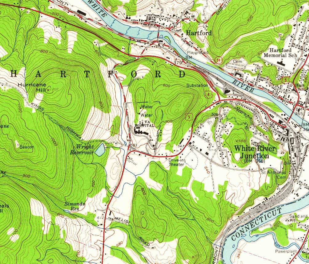 1959 USGS Map Showing White River Junction, and Hartford villages, and Sykes Avenue Area. Above, King's Highway is shown as an umimproved road. The intersection with US Route 5, (North Hartland Road), and the V.A. Cutoff Road is shown in the center, just east of Wright Reservoir, and just below the V.A. Hospital. Below is another look at the same area, from 2018. Note the addition of the interstate Highways. On the far left "KINGS HWY" can be read, and it looks like the eastern end of it either sort of vanished or was rerouted to accomodate the Interstate and then became Wright Reservoir Road. I suspect that if you drive up Wright Reservoir Road to the end, you'll probably find vestiges of the old King's Highway in the woods. 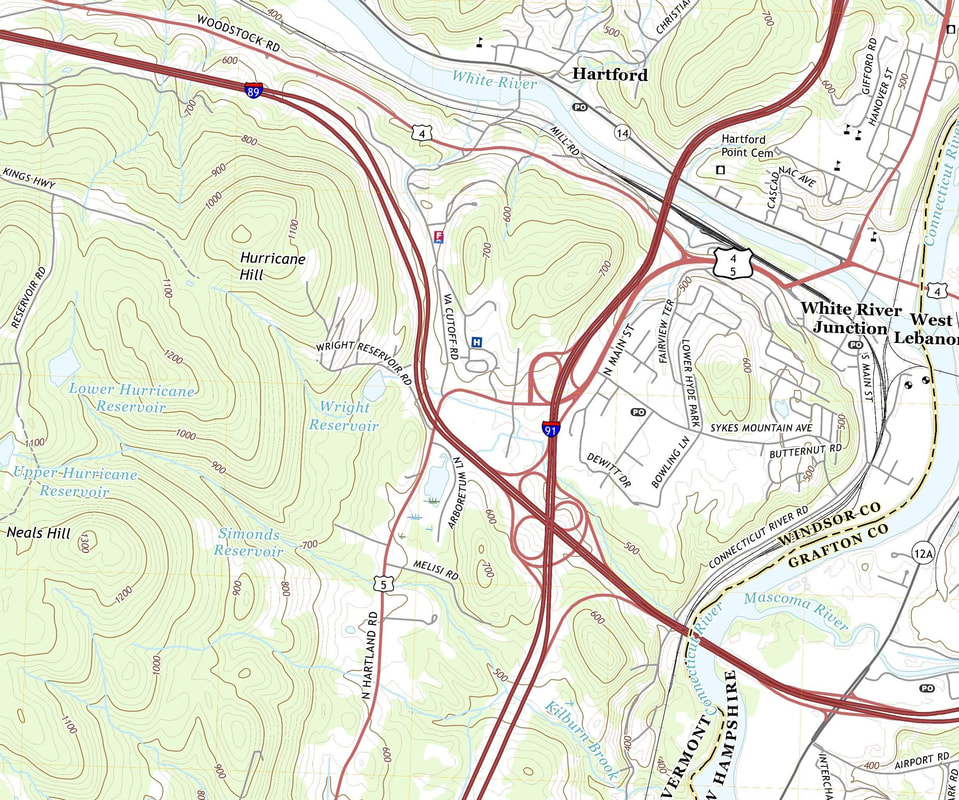 2018 View. King's HIghway, labeled "KINGS HWY" in upper left. Below, also a 2018 view, (just to the west of the previous map), it appears that KINGS HWY goes across Center of Town Road, and then right through the on and off ramps of Exit 1, I-89 in Quechee! We'll look into that further in the next episode of... THE KING'S HIGHWAY 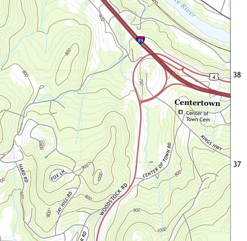 Thanks for traveling down Old Roads, Rivers and Rails of the Upper Valley with me, Bob Totz. If you'd like to subscribe to these articles, posts, blogs, what have you, just send an email to me at [email protected] and I'll add you to the growing list of subscribers who get timely notices of published posts. I extend my warmest thanks to all who have subscribed! Do you have an interesting story to tell, related to this article? We'd love to hear it! Just click on comments and add your thoughts. Thanks! 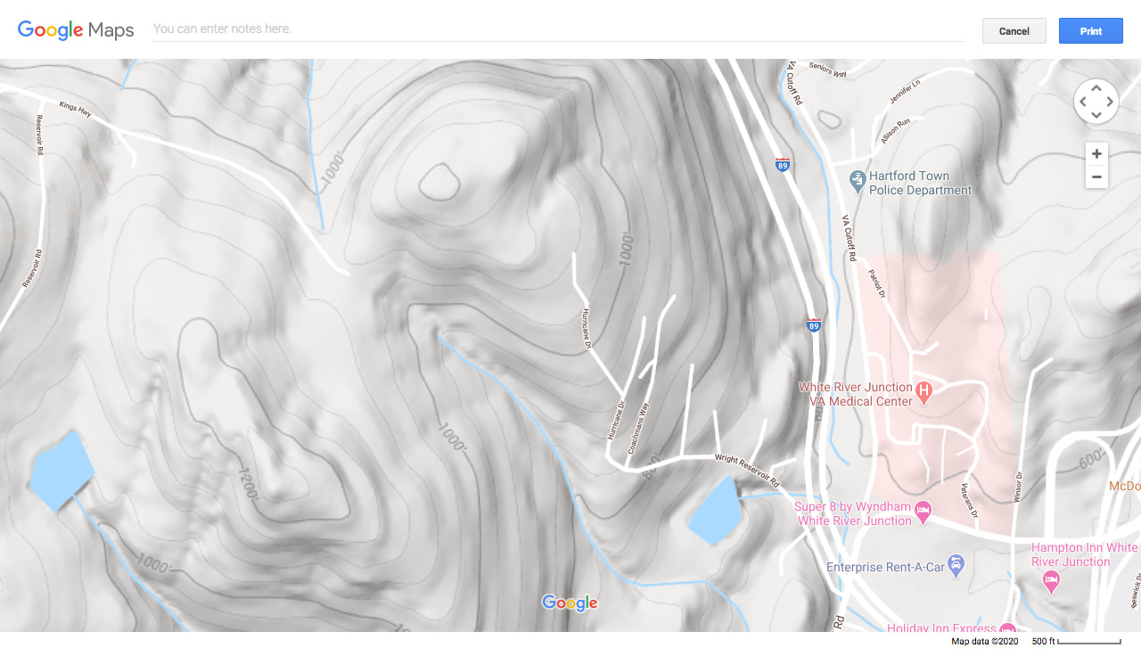 2020 Google Earth Imagery, White River Junction, Vermont. Many early roads followed ridge lines, as well as river valleys. In the history of American highways, we find that many of the early Indian trails ran along the ridge lines for protection purposes. Staying to the ridgelines and high points also provided some relief from the mud and mire of lower elevation routes. The routes of early settlers often started by following these Indian "High-Ways", which were later widened, straightened, detoured, discontinued, or improved, and so on. The "High-Ways" were some of the greatest of the 19th century roads. Some still exist and can be driven on today. We'll see if we can take the old "High-way" to Montpelier by following the old roads of yesterday, that were fit for a King! Sources: 1855 Map of Windsor County Vermont, by Hosea Doton: https://www.loc.gov/resource/g3753w.la001193/?r=0.662,0.518,0.133,0.056,0 Interview with David Brown, Hartford Agricultural Oral History Project: www.hartford-vt.org/DocumentCenter/View/276/HOHP_Brown_Transcript1?bidId= US Geological Survey, Topoview: https://ngmdb.usgs.gov/topoview/viewer/#15/43.6368/-72.4095 History of Hartford Vermont by William Howard Tucker, published in 1889: https://ia802609.us.archive.org/22/items/historyofhartfor00tuck/historyofhartfor00tuck.pdf 1931 VTrans Map of Hartford VT: https://maps.vtrans.vermont.gov/Maps/TownMapSeries/WINDSOR_Co/HARTFORD/HARTFORD_1931.pdf Hartford by Frank Barrett, p. 98 Vermont State Fairgrounds Hartford VT Historical Society: http://www.hartfordhistory.org/12103.html Google Earth: https://www.google.com/maps/place/White+River+Junction,+Hartford,+VT/@43.6480418,-72.3365708,2220m/data=!3m1!1e3!4m5!3m4!1s0x4cb4cb9cfdff35bd:0xe460379aa54a2b52!8m2!3d43.6489596!4d-72.3192579 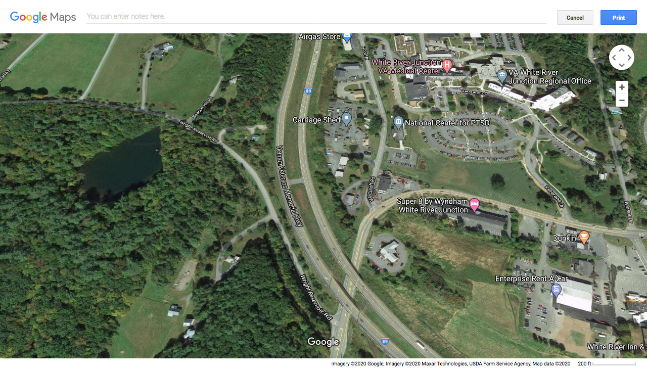 The old Four Corners Ain't What She Used to Be!
4 Comments
suzi r
2/27/2020 01:05:54 pm
Wow, Bob!
Bob Totz
2/29/2020 06:36:34 am
Thanks, Sue
George Chapman
2/27/2020 04:02:58 pm
"Older Gentleman" hmm, I guess I qualify even though I still think I am in my 30s or 40s!
Bob Totz
2/27/2020 04:48:56 pm
Ha ha ha ha ha! Your comment will be posted after it is approved.
Leave a Reply. |
AuthorI'm Bob Totz, retired VT postmaster, and historical geographer ARCHIVES:
October 2021
EXPANDED ARCHIVES: AUGUST 2021 1858 Johnson Map of North America MAY 2021 1795 - "Road Over the Mountain" - Part Two Historic Toll House For Sale 1795 - "Road Over the Mountain" Part One OCTOBER 2020 Finding That Special Peaceful Place AUGUST 2020 Kayaking on the Pompy JULY 2020 Pt. 2: What the Heck Are These Things? JUNE 2020 Bob's Bio... What the Heck Are These Things? Pt. 1 MAY 2020 Stone Walls and Spirits The View APRIL 2020 Sunny Brook Farm Relics: Pt 2. Sunny Brook Farm Relics: Pt 1. MARCH 2020 Signs of Norwich Pt. 2 COVID-19 Tracking Map Centertown and Valleyquest Signs of Norwich Pt. 1 "Imperfect Union" - Book Review Historic Centertown FEBRUARY 2020 King's Hwy Pt. 2 WRJ Museum at Post Mills Airport Chatauguay Vermont The Independent Farmer poem Traveling Along the King's Highway - Lebanon NH JANUARY 2020 Finding Parkhurst Cemetery In Search of Parkhurst Cemetery Affordable Housing The Old Stone Grill Two Rivers Trail-Kmart License and Registration, Please! Prohibition, Murder and Dr. Seuss Peace, Paris, & P.O. DECEMBER 2019 BLOGGER'S LINKS Welcome to Old Roads Love-Quail Hollow fun Dartmouth Cemetery SEPTEMBER 2019 E. Thetford Cemetery JUNE 2019
Taps: Meetinghouse Cemetery 4-Corners Borders Quest Old Iron Gate Stumbling Upon History Sunrise Walk MAY 2019 4 Corners Cemetery Strafford's Abandoned Foundations Art in Old Stonework APRIL 2019 Strafford Tpke Pt 2 Strafford Tpke Pt 1 White River Valley FEBRUARY 2019 Learning from Historic Maps of the Upper Valley Change in Lewiston VT JANUARY 2019 A Vermont Ski Waltz John Ledyard 1773 What is the Upper Valley? DECEMBER 2018 Dartmouth Green Music Video: Sometimes Music Video: Montreal Express Railway Disaster of 1887 |
 RSS Feed
