|
Welcome! Scroll Down for Posts and Archives.
Other Menu Options at Top |
|
|
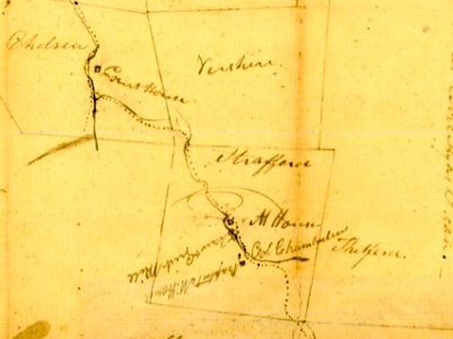 From the Ledyard Bridge, through Norwich, Sharon, Strafford, and Vershire, and Ending at the Chelsea Courthouse. The Strafford Turnpike was, and probably still is, the shortest, most direct route from the Connecticut River in Norwich, to the Chelsea Vermont Courthouse. However, what used to be a main highway, back in the early 1800's, is now, in several places, a washed out old trail, left to the ravages of nature and time. In other places, it is still used, but cleverly disguised as "Main Street" in Norwich, or Justin Morrill Memorial Highway in Strafford. And a couple of stretches are known as "Turnpike Road". About a month ago, a neighbor brought the Strafford Turnpike to my attention. In that I love old roads around here, and hadn't heard of the Strafford Turnpike, I decided to do some investigating on my own. My neighbor gave me some research materials that came from the State of Vermont, State Archives and Records Administration. Plus, I had access to some old maps of the area. 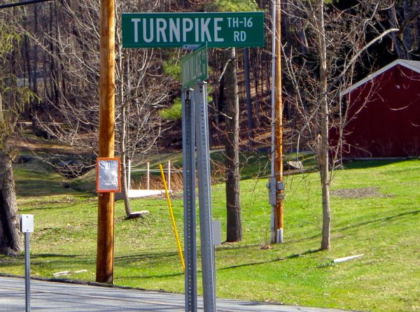 Turnpike Road in Norwich, formerly The Strafford Turnpike It turns out the Strafford Turnpike turned northwest from Main Street Norwich, onto what is now called Turnpike Road. I had never really given much thought to the name, Turnpike Road, but now it was starting to make sense! Below is an old hand drawn sketch/map of the route of the Strafford Turnpike. It doesn't look like much, but it provided some good clues. The Strafford Turnpike is indicated by a dotted line. Waterways are indicated by solid lines, and township boundary lines are also drawn in. The route ran from Norwich, through the northeast corner of Sharon, before entering Strafford. The other good clue is that, from Strafford, the route ran through the southwest corner of Vershire. 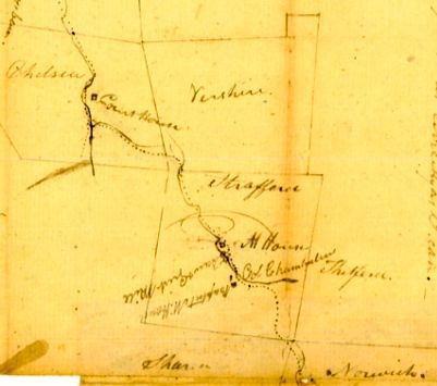 I was curious about the route from Turnpike Road out of Norwich. The map below shows another, more detailed sketch of the southeastern portion of the area that the Strafford turnpike ran through, from Norwich, through Sharon, and into Strafford. 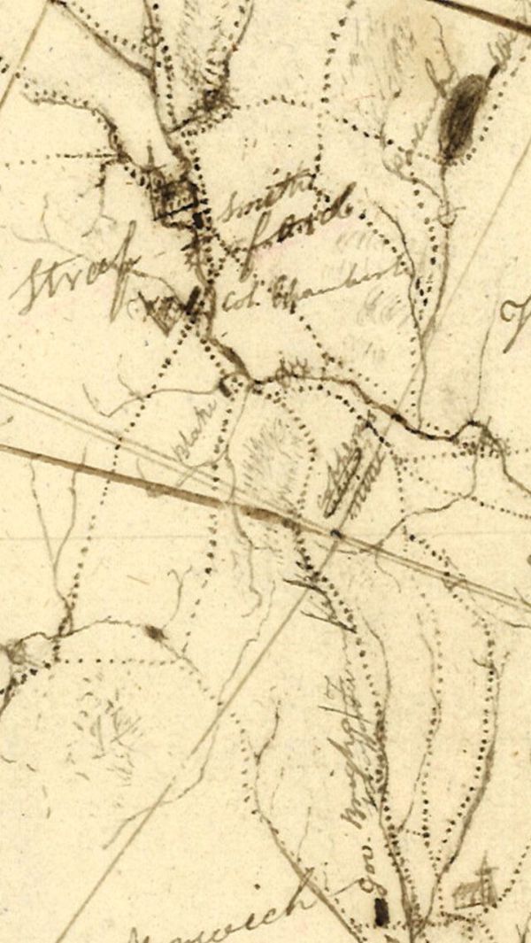 Early map of The Strafford Turnpike in Norwich, Sharon, and Strafford. About ten years ago, my wife and I hiked out the non-maintained portion of Turnpike Road. We walked along the road for a while, noting that at one point, it must have been used by lots of people, as it was wide, with old stone walls on each side, and even though it was almost beyond drivable, you could tell that at one point it had been graded and maintained. 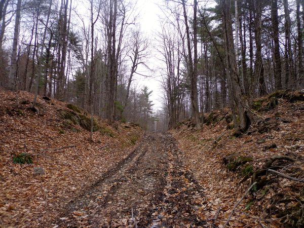 Class 4 portion of the Strafford Turnpike in Norwich, near Sharon Vermont Eventually we came to a 4-Corners of old roads. To the left, a road came in which was in about the same shape as the one that we were on. To the right, another old road, and ahead, and uphill, it appeared that the Turnpike continued on. The area was a bit wet, especially straight ahead. I went straight for a little bit, and saw an old pond, or marshy area, and then walked back to the four corners, not knowing that I had been on the Strafford Turnpike of days gone by. 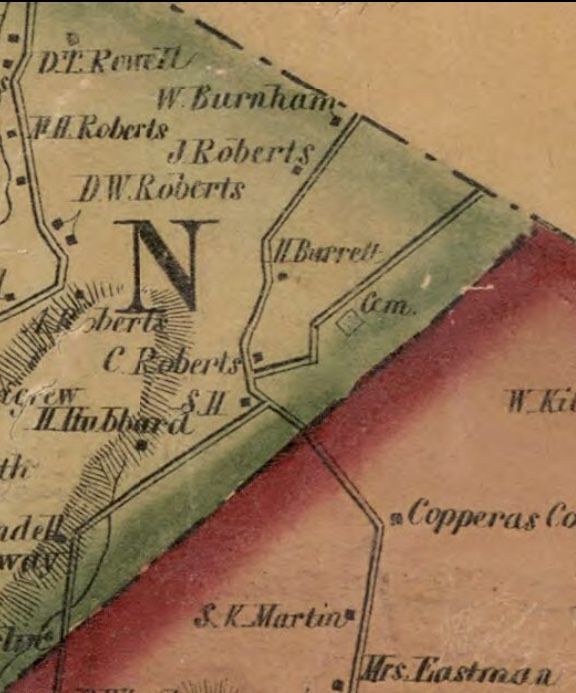 Strafford Turnpike, Copperas Road, and Chapel Hill Road, Norwich to Sharon. Cemetery we visited is drawn in on Copperas Road, upper right. From the 1855 Map of Windsor County. On the map above, from Windsor County, VT in 1855, we can see a cemetery drawn in on Copperas Road, upper right. It appears there was a schoolhouse ("S.H.") near the 4 corners, and it looks like C. Roberts lived near there, along with H. Barrett a little further up the turnpike. On our walk, we headed northeast, along an east facing ridge for a little ways. It was a nice area, with a view of Smart's Mountain in one spot, and an old graveyard with a fence. We had turned onto what used to be Copperas Road going northeast, toward the former Copper Mine. Had we gone left, we would have been on Chapel Hill Road going southwest, toward the Beaver Meadow area of Sharon and West Norwich. 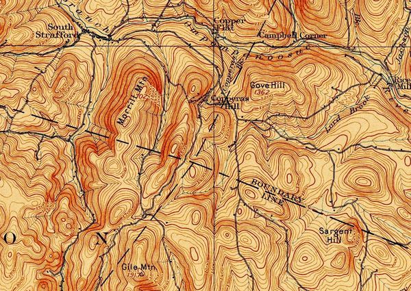 1894 USGS Topographic Map showing the Corners of Norwich (Lower Right), Sharon (Lower Left), Strafford, (Upper Left), and Thetford, (Upper Right). The 1894 map above helps us to see where Turnpike Road out of Norwich used to go. It continued on, past Gile Mountain, and into Sharon, where it came to a four corners area, which is where we had hiked. We had turned right, but the Strafford Turnpike continued straight from there, eventually coming down into South Strafford, between Copperas Hill, and Morrill Mountain. 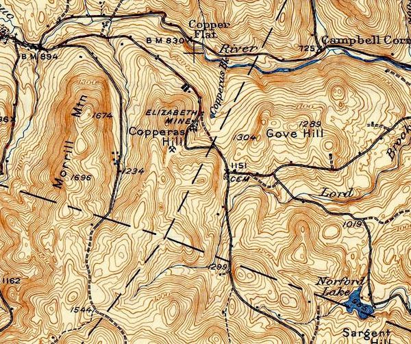 1944 USGS map showing the Strafford Turnpike, now in double-dashed lines. The map above was produced in 1944, fifty years after the 1894 map. There are some changes we can note. Copperas Road has been removed, though Elizabeth Mine is written in, near Copperas Hill. Chapel Hill Road, which had been a solid line, is now a single dashed line. And the Strafford Turnpike is now a double-dashed line, indicating an unimproved road, i.e. no longer being used much. The Strafford Turnpike still exists on the South Strafford end, but, as the saying goes, "You can't get there from here". Well, you probably could get there by walking, or on horseback, but you probably won't be driving a car to South Strafford from Turnpike Road in Norwich these days. 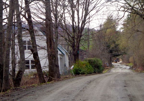 Turnpike Road in Strafford Above is a look at the South Strafford end of Turnpike Road, or the Strafford Turnpike. I took this photo this week, but didn't venture on, as the road crew was up ahead working, and it was still mud season. ******************** A Little History ****************** Back in the early 1800's, the road system in Vermont and New Hampshire was dominated by private toll roads called turnpikes. The idea was that a group of investors would petition to the legislature to form a company, to build and oversee a new turnpike, and collect tolls from travelers. Then, they would survey, clear, build and maintain a road, and collect tolls from folks for the privilege of traveling along the turnpikes, in hopes of making a profit. The term turnpike came about because at the tollgate, a gate, or "pike" was used to block access until the toll was paid. When the toll was paid, the pike was turned to the side so that the travelers could pass, hence the term, "turnpike". Here is an excerpt from the original petition to the Legislature of the State of Vermont for the Strafford Turnpike: ......." a turnpike road from Hanover bridge crossing Connecticut River to Chelsea will be of quick public utility in shortening the distance of public travel.......the right to ......make a turnpike road in the best place from said Bridge to Chelsea Court house.....under such regulations and instructions as you in your wisdom shall see fit......dated at Norwich this sixth day of October 1807." The petition was signed by William Little, Elisha Burton, and others as seen below. 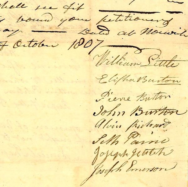 Strafford Turnpike petition signatures, 1807 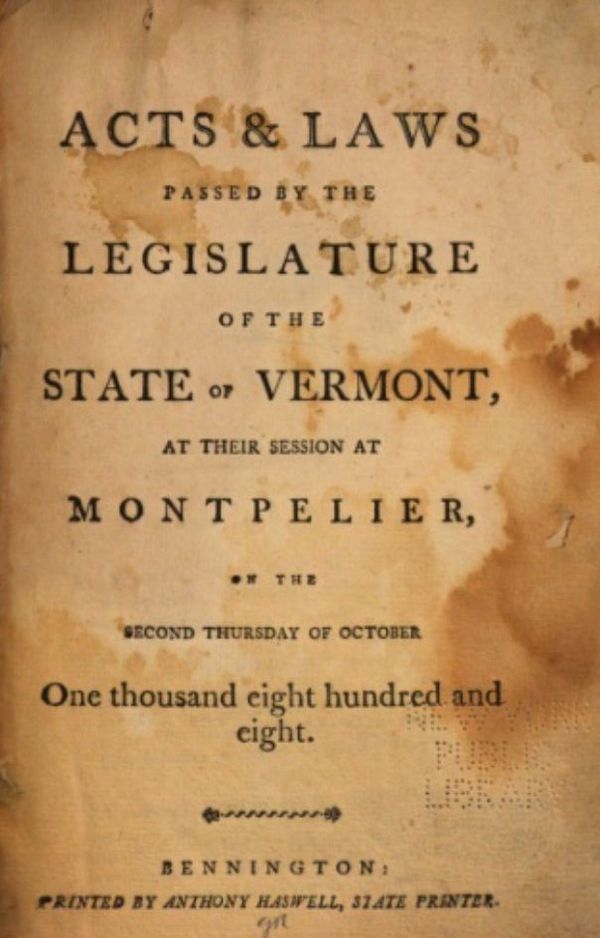 Cover page of the 1808 "Acts passed by the Legislature..." From "1808 Acts passed by the Legislature of the State of Vermont" chapter 117: "An act establishing a corporation by the name of the Strafford turnpike company. It is hereby enacted by the General Assembly of the State of Vermont, that Ebenezer Brown and Elisha Burton of Norwich, in the county of Windsor, and Asahel Chamberlain, of Strafford and Josiah Dana of Chelsea, in the county of Orange, and their associates and successors, be and they hereby are constituted a corporation, by the name of the Strafford Turnpike." ...."for the purpose of laying out, making, altering, & keeping in repair a turnpike road, from the Connecticut River turnpike road, in Norwich....in the most direct and eligible way from said turnpike, to the courthouse in Chelsea...." 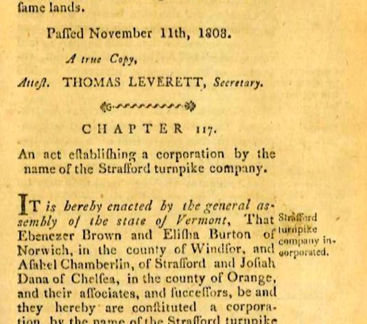 Excerpt from "Acts passed by the Legislature..." On its way, to Chelsea, the turnpike ran through five towns: Norwich, Sharon, Strafford, and Vershire, and finally, Chelsea Vermont. One of the goals of the Turnpike was to shorten the distance to the Chelsea Courthouse, shortening the time needed to travel there and back. Therefore, the route taken was supposed to be the shortest distance possible, taking into account larger hills that had to be traveled around, and wet valleys that would be better to avoid if possible. It made sense that the Turnpike would follow the main path into Norwich from the Ledyard Bridge. And it makes sense to me, now, that they turned left onto what we know today as Turnpike Road. Thanks for meandering down "Old Roads, Rivers and Rails". Feel free to click the subscribe button to get an alert when I publish Part Two of the Strafford Turnpike, and other posts to come. Click Here For Part Two of the Strafford Turnpike...From Strafford to Chelsea. Other journeys on "Old Roads Rivers and Rails" can be found at the Profile Page here: https://herecast.us/@OldRoadsRiversandRails and the post that started it all: The Montreal Express Railway Disaster of 1887 Source of historic documents: Vermont State Archives & Records Administration: https://www.sec.state.vt.us/archives-records/contact-us.aspx Thanks also to Doug Wilberding for sharing information and source documents. Map Sources: USGS: https://ngmdb.usgs.gov/topoview/viewer/#9/43.7552/-72.0744 Orange County: https://www.loc.gov/resource/g3753o.la001188/?r=-0.043,0.274,0.124,0.147,0 Windsor County: https://www.loc.gov/resource/g3753w.la001193/?r=-0.138,0.737,1.002,0.415,0 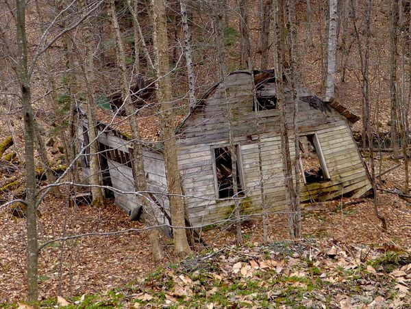 An old relic along the Strafford Turnpike that has seen better days Bob Totz Norwich, VT Comments 19
Dan Webb · 7 months ago · Report Nice read Bob ! Thanks .
1 Comment
Brian Ball
1/25/2021 11:33:17 am
As a child, I lived in the white house with white picket fence across the street from Huntley Meadow. From our understanding, this was the homestead for the mink farm. The left section was a one room schoolhouse with living quarters on top that was located a few miles up the road and moved down. The middle portion was an extension to the house to accommodate a family. And the section on the right was a quasi replica of an old barn structure. The barn that was attached to the house was in place and used as a car garage until my parents had it torn down and rebuilt as an extension to the living area in the 1980’s. I vaguely remember it from my childhood. Your comment will be posted after it is approved.
Leave a Reply. |
AuthorI'm Bob Totz, retired VT postmaster, and historical geographer ARCHIVES:
October 2021
EXPANDED ARCHIVES: AUGUST 2021 1858 Johnson Map of North America MAY 2021 1795 - "Road Over the Mountain" - Part Two Historic Toll House For Sale 1795 - "Road Over the Mountain" Part One OCTOBER 2020 Finding That Special Peaceful Place AUGUST 2020 Kayaking on the Pompy JULY 2020 Pt. 2: What the Heck Are These Things? JUNE 2020 Bob's Bio... What the Heck Are These Things? Pt. 1 MAY 2020 Stone Walls and Spirits The View APRIL 2020 Sunny Brook Farm Relics: Pt 2. Sunny Brook Farm Relics: Pt 1. MARCH 2020 Signs of Norwich Pt. 2 COVID-19 Tracking Map Centertown and Valleyquest Signs of Norwich Pt. 1 "Imperfect Union" - Book Review Historic Centertown FEBRUARY 2020 King's Hwy Pt. 2 WRJ Museum at Post Mills Airport Chatauguay Vermont The Independent Farmer poem Traveling Along the King's Highway - Lebanon NH JANUARY 2020 Finding Parkhurst Cemetery In Search of Parkhurst Cemetery Affordable Housing The Old Stone Grill Two Rivers Trail-Kmart License and Registration, Please! Prohibition, Murder and Dr. Seuss Peace, Paris, & P.O. DECEMBER 2019 BLOGGER'S LINKS Welcome to Old Roads Love-Quail Hollow fun Dartmouth Cemetery SEPTEMBER 2019 E. Thetford Cemetery JUNE 2019
Taps: Meetinghouse Cemetery 4-Corners Borders Quest Old Iron Gate Stumbling Upon History Sunrise Walk MAY 2019 4 Corners Cemetery Strafford's Abandoned Foundations Art in Old Stonework APRIL 2019 Strafford Tpke Pt 2 Strafford Tpke Pt 1 White River Valley FEBRUARY 2019 Learning from Historic Maps of the Upper Valley Change in Lewiston VT JANUARY 2019 A Vermont Ski Waltz John Ledyard 1773 What is the Upper Valley? DECEMBER 2018 Dartmouth Green Music Video: Sometimes Music Video: Montreal Express Railway Disaster of 1887 |
 RSS Feed
