|
Welcome! Scroll Down for Posts and Archives.
Other Menu Options at Top |
|
|
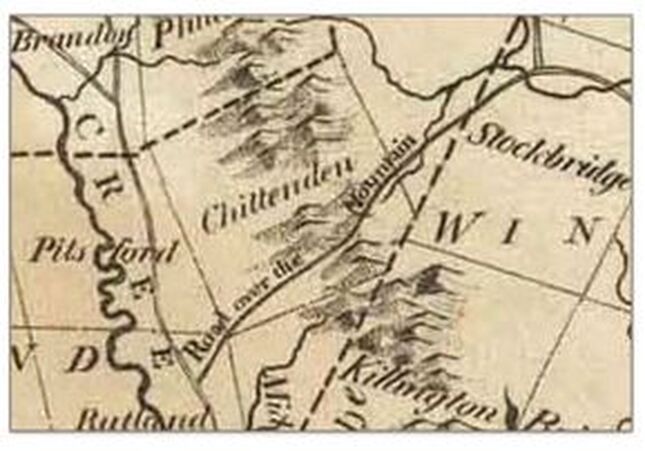 Inset from the 1795 map of Vermont by Carey In Part one of "The Road Over the Mountain" we explored the west end of this old 18th century route, shown in the above inset from the 1795 map of Vermont by Carey. In part one we traveled from Rutland to East Pittsford village. Now we'll continue, through Chittenden, and over the Green Mountains, to Stockbridge Vermont. Below is a modern Google Earth aerial view, which points to the village of East Pittsford, in the East Creek Valley, and shows the wilds of Chittenden Vermont, to the east. 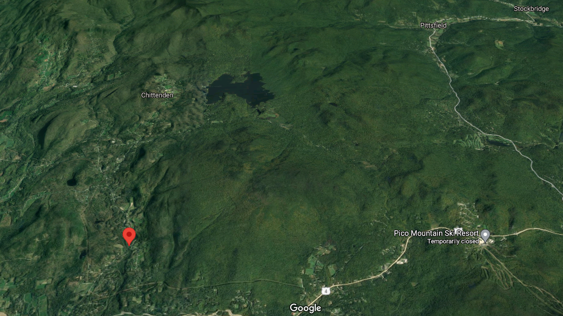 Village of East Pittsford, (at pointer). Chittenden Reservoir show above. image courtesy GoogleEarth The Chittenden reservoir can be seen in the upper central portion of the photo above. In this photo we can get an idea of the lay of the land, and we can see why the old Road over the Mountain probably wound around Blue Ridge Mountain, (elevation about 3250 feet), east of East Pittsford village, and south of Chittenden village. 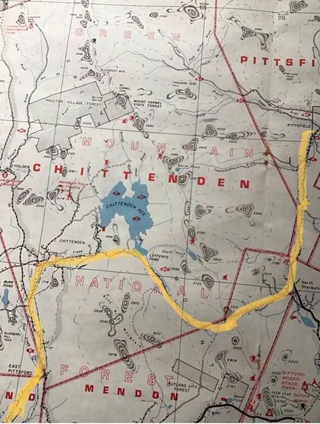 Inset from a Vermont Atlas published by DeLorme in the 20th century. Above, is a 20th century view showing the area, from a DeLorme Gazeteer I bought about 40 years ago. We can see what I believe is the Road over the Mountain, (highlighted by me). The Road Over the Mountain appears to go through the southeast tip of Pittsford, then northeast into Chittenden, followed by a turn east, then south. Then it heads south of Chittenden Pond (now Chittenden Reservoir), then east, then back north again, into North Sherburne, and then Pittsfield, (as opposed to Pittsford), before terminating in Stockbridge. Naming the Road(s) Today Identifying the route by today’s road or trail names is the next step. We started out by following East Pittsford Road from Rutland, through East Pittsford. In East Pittsford, the road name turned to “Chittenden Road”, and in Chittenden I’ve seen it labeled, “East Pittsford-Chittenden Road”. 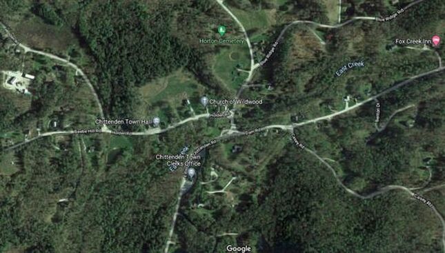 South Chittenden Vermont. Courtesy GoogleEarth. Continuing along the old route, after East Pittsford, we head to the village of South Chittenden. We pass by the Chittenden Post office on the right, followed by the Chittenden Town Clerk’s office, seen above. Below is a look at the South Chittenden in 1869. We see a busy village with at least two sawmills, a grist mill, a blacksmith shop, a store and a post office, and a "proposed railroad". 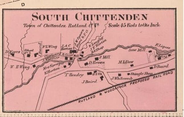 South Chittenden Village, 1869. Beer's Atlas Just past the Chittenden Town Clerk’s office, we continue on what is now known as “Dam Road”, no doubt named when the dam and reservoir were built. Here, be sure to avoid Mountain Top Road which goes to the left, and Casey Road, which is a right turn. In the photo below, the town clerk’s office in South Chittenden is in the lower left. We can see Dam Road leading east, over toward where Chittenden Pond was dammed to create the reservoir. The construction of the dam began in 1900. 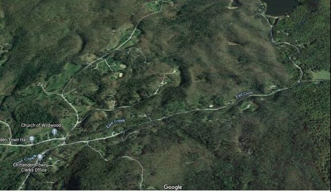 South Chittenden village, East Creek, and Dam Road. Courtesy GoogleEarth. Just before Dam Road heads north to the reservoir, there is a right turn. This right turn, I believe, is the continuance of our 1795 “Road over the Mountain”. Today, the next portion of the old road is known as “Wildcat Road”. I can only imagine why it was named that! Here is a look at that intersection, where we will bear right: 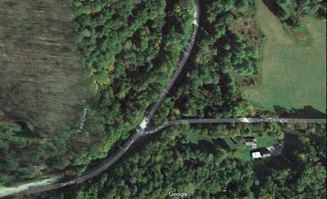 Turn onto Wildcat Road. Courtesy GoogleEarth. Outskirts of Town Have you ever noticed that many of the oldest roads, that have become discontinued and overgrown, are often located in the most remote regions of towns? Year after year, many of those forgotten roads are slowly returning back to their natural, forested state. Many of our township boundaries are located along the areas of least population density, on the outskirts of towns. Many of these areas, often farthest from town centers, had been populated by subsistence farmers in the early - mid 19th century. These farms were often in the higher elevations, as town centers were usually formed in valleys around rivers and streams, in the lowlands. In the mid-1800’s, almost three quarters of the land in Vermont, below 2000 feet elevation, had been cleared for crop raising, and sheep and cattle pasture. Many of the old roads, or portions of them, can still be found out there, in those formerly populated, remote highlands. Take a look at this area of outskirts below. Look at the township boundaries, and how they were delineated, where five townships meet: The boundaries of Chittenden, Mendon, Sherburne (now Killington), Pittsfield and Stockbridge all come close to one another in this rural region. Also, these boundaries were adjusted and modified over the years. (Compare the township boundaries on this 1869 map, to the boundaries on the highlighted DeLorme road map above.) 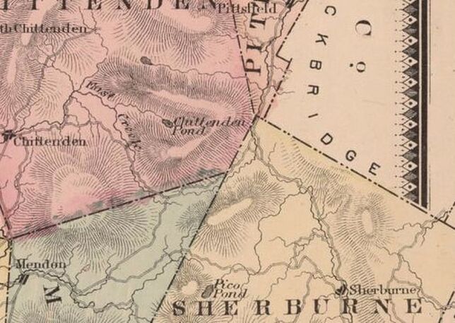 1869 view from Beers’ Rutland County Map, Showing Wildcat Road, Connecting with Old Turnpike Road, and Elbow Road Today, in Northern Mendon and Sherburne Townships. In the next view, we see our road climbing along East Creek to its source, just after crossing into extreme northeast Mendon township. From there, it eventually travels east, over the Green Mountains, through a gap now known as "The Elbow" As the road and creek climb, we'll pass camps and houses along the way. Eventually, the road seems to disappear into a wet area near the highest elevation. Just before the high, wet area, "Old Turnpike Road" comes in from the south, on the right, and joins Wildcat Road. Old Turnpike Road may be a remnant of the "Rutland and Stockbridge Turnpike" that was chartered in 1804. You can read a little about the Rutland and Stockbridge Turnpike in "Turnpikes of New England" by Frederic J. Wood, published in 1919, pg. 263. Here is a link to that page: https://archive.org/details/turnpikesofnewen00woodrich/page/262/mode/2up Here is an excerpt from a short history of Mendon VT, that relates to "Old Turnpike Road": "Mendon was located on the main road from Rutland to Woodstock. In 1807 a town meeting was held to lay out a turnpike and other roads. The result was the Rutland, Woodstock and Stockbridge Turnpike. It followed the present line of Woodstock Avenue to Mendon, went behind the present town office. At the present Old Turnpike or Elbow Road, it divided with one branch going left to Lefferts Pond and Chittenden and the other over the Sherburne pass through Bridgewater to Woodstock. The branch to Chittenden was used as the mail route as late as 1875." I suspect the Turnpike later became the preferred route to Stockbridge, as it appears to be a shorter distance. Both routes connect and cross the gap at the Elbow. 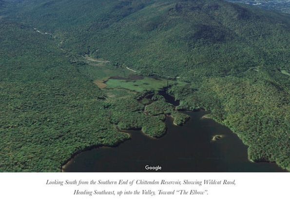 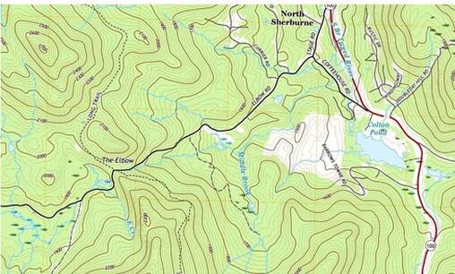 "The Elbow" is where the Road Over the Mountain now intersects with the Long Trail. Imagery courtesy USGS, 2018. "The Elbow" depicts a gap over and through the Green Mountains. The Long Trail intersects at this point. Above, Old Turnpike Road can be seen joining Wildcat Road, near the marshy area in the lower left, depicted as dashed line. Just beyond the junction with Old Turnpike, we find the source of East Creek, a wide, wet area that was probably difficult to maintain as a road. This is just before the height of the land. The 2018 US Geological Survey map view is shown above, Interestingly, on this modern map, Wildcat Road, (sometimes depicted as Old Turnpike Road after that junction), which becomes Elbow Road, is depicted as if it is a maintained road all the way through the gap. Below is a relief map from GoogleEarth, of the Elbow area, which shows elevation well, and does not show the road continuing through The Elbow, though I'm sure it still exists, for the most part, at least as a trail. 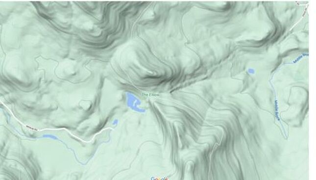 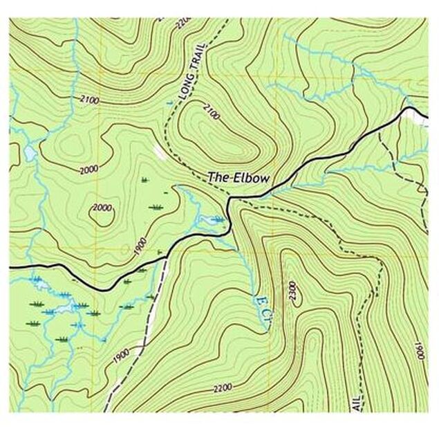 "The Elbow" 2018 USGS imagery "The Elbow" 2018 USGS imagery The Elbow is at the highest elevation, about 1950 feet. It is where the “Road Over the Mountain” actually went over the mountain, and then down the other side. The old Road Over the Mountain crosses the north-south route of Vermont’s “Long Trail”, which is the oldest long distance hiking trail in the United States. 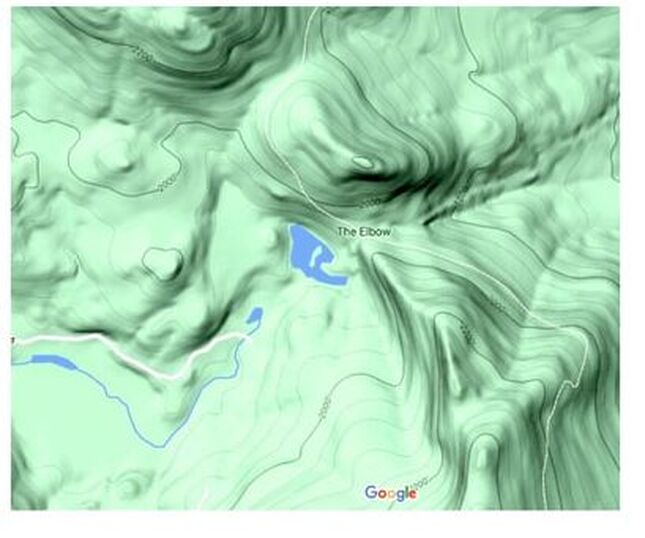 GoogleEarth relief map showing the high country as the Road Over the Mountain heads over the mountain at The Elbow. Today this old road intersects with The Long Trail. On the relief maps, it appears that the road is no longer maintained in the highest elevations, while on the 2018 USGS map, the road appears to be continuous. I’d really like to head out there and see for myself. It would be fun to hike in from the Long Trail, and then head west or east, and see what the old road looks like today. WATERSHEDS To the west of The Elbow, lie the headwaters of East Creek, which flows into Otter Creek, which flows from there into Lake Champlain, which flows north to the Ricelieu River, which empties into the St. Lawrence Seaway. To the east of The Elbow lie the tributaries of the Tweed River, which flows into the White River, which flows into the Connecticut River, which flows into Long Island Sound and the Atlantic Ocean. Below is a 3-D look at the area where the road crosses over the mountain. This GoogleEarth image, appears to show the old Road Over the Mountain snaking around the marsh. "The Elbow" is shown in fine print, upper right. 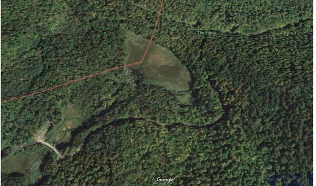 The Road Over the Mountain would have to go through, or around this wet area just before the gap at The Elbow. Courtesy GoogleEarth. Here is a closer look at that marsh, or wet area just before The Elbow: 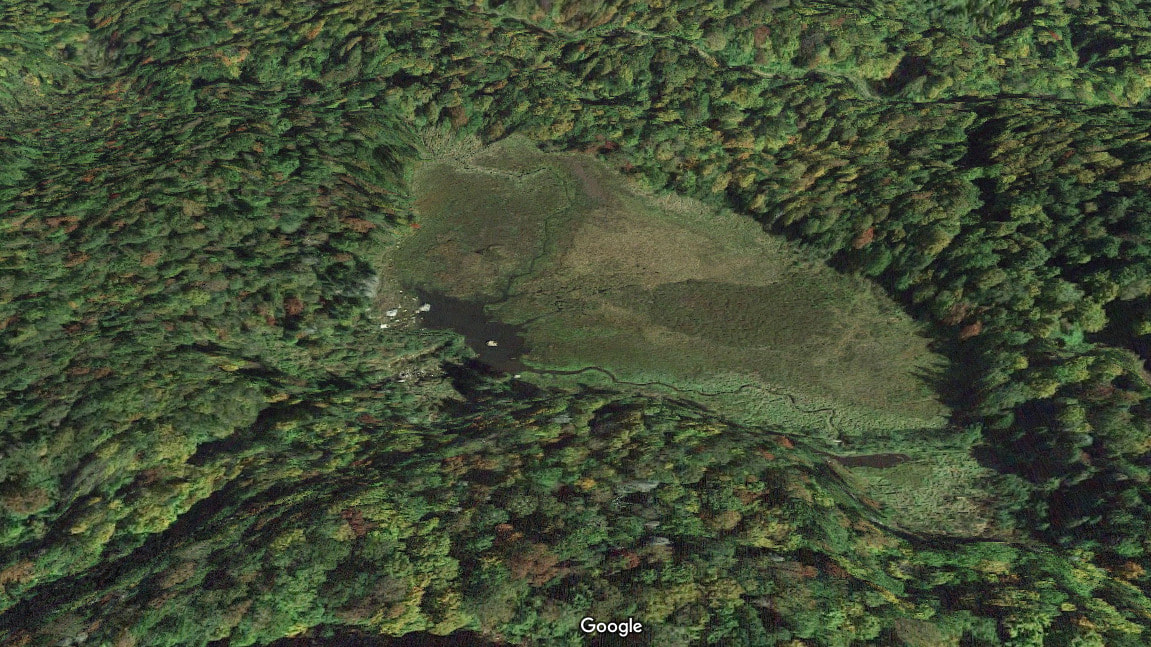 Wet area just before The Elbow. Courtesy GoogleEarth. Before we leave the top of the mountain, consider this: At The Elbow, the Long Trail continues for a short time, on an old railroad bed. 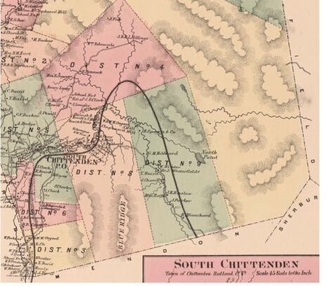 The Railroad bed had been prepared for an east-west, cross Vermont Railroad that was never completed. The proposed route is shown on the map above, from the 1869 Beers’ Atlas. The view shown below is LOOKING SOUTH. It shows the old railroad bed, that the Long Trail follows for a short distance. The Elbow is shown in upper right, and the high marshy area is a bit lower, to the right. 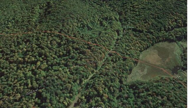 Photo courtesy GoogleEarth. After climbing and going through The Elbow, the road descends east, into the Tweed River Valley. The GoogleEarth photo below shows The Elbow in the far left, and we can make out a portion of the road that heads east, now known as Elbow Road. 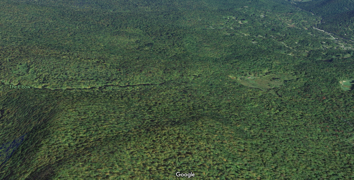 As the road descends from the Green Mountains into the Tweed River valley, civilization becomes more prevalent. 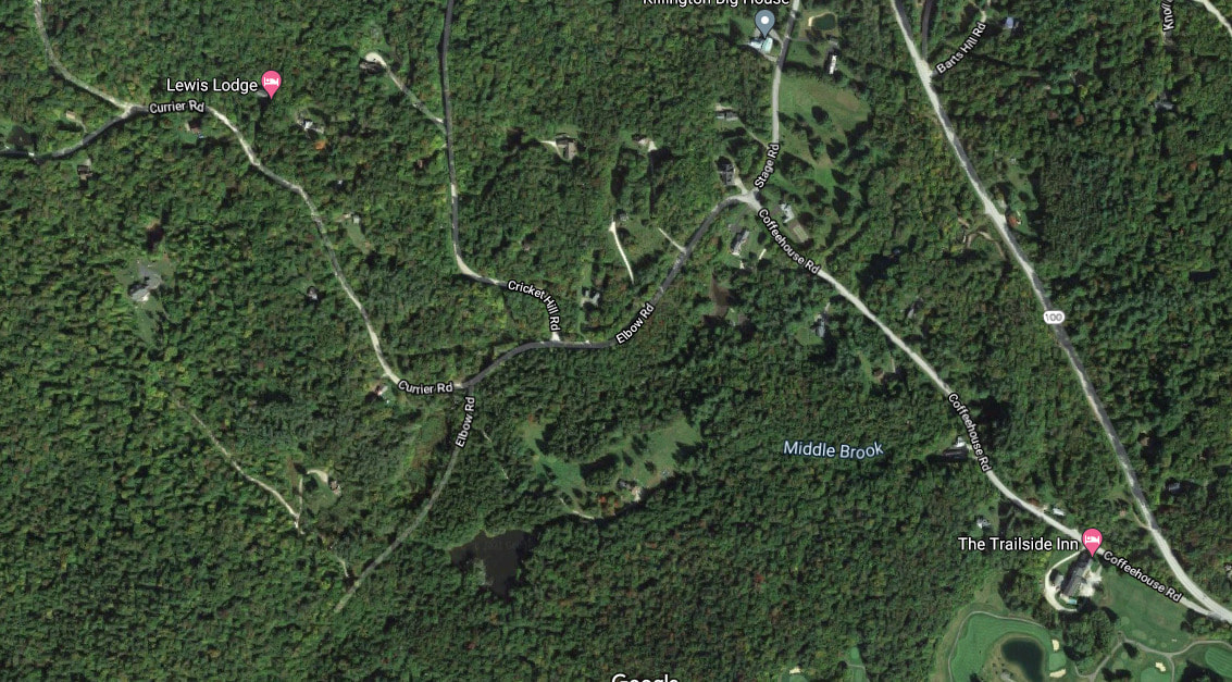 The photo above shows the area where Elbow Road comes down into North Sherburne. Here Elbow Road intersects with Stage Road and Coffeehouse Road in North Sherburne. I believe the Road Over the Mountain continued on Stage Road, and headed north to Stockbridge, along what is now Route 100. Just before the intersection of Elbow Road with Route 100, our road crosses the south branch of the Tweed River. From there, I suspect the old route was roughly the same as today's route 100, which heads up to the junction of the Tweed and White Rivers, and the western end of today's Route 107. The Road Over the Mountain must have paralleled the White River, on its way north to Stockbridge, though it may have run on the east side, near what is now Blackmer Boulevard, and/or Common road into the center of Stockbridge. 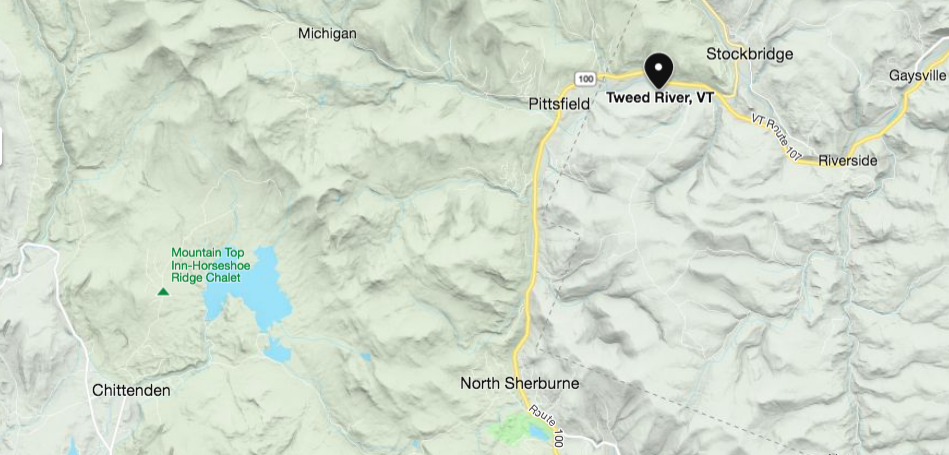 Area of Vermont showing Chittenden, North Sherburne, Pittsfield, and Stockbridge. Courtesy Microsoft Bing. Below is a modern look at the area near the confluence of the Tweed and White Rivers, including Stockbridge, to the north. 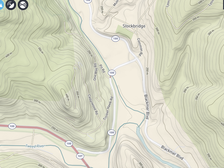 USGS Topographic Imagery. It's fun to look at routes on old maps, and try to figure out where they would be today. But can you imagine the amount of effort required to travel from Rutland To Stockbridge in 1795? It must have really been something! I expect the trip would have been made either on foot, or horseback at that time. I don't know if it would have been wide enough for wheeled traffic in 1795. Back in 1795, the road was probably no more than a bridle path, probably widened out from a trail made there by native americans. The native americans in turn, probably developed the trail based on animal trails that most likely went through The Elbow gap. The native americans may have found the trail while hunting game. The trail probably existed for hundreds of years before european settlers arrived. Still, I wonder if the "Road Over the Mountain" may have actually gone up and over Blue Ridge Mountain, and connected with Wildcat Road on the other side... There's a road in there called Stone Hollow Road....hmmm.....nahhh, couldn't be. Or could it? Maybe someone out there can enlighten me! Thanks for traveling down Old Roads, Rivers and Rails, with me, Bob Totz. If you like these kinds of stories, feel free to subscribe, by sending an email to [email protected] Portion of Railroad bed used for Long Trail: https://www.greenmountainclub.org/hiking/accessible-trails/ The Rutland and Stockbridge Turnpike, p. 263: https://archive.org/details/turnpikesofnewen00woodrich/page/264/mode/2up 1795 Map of VT by Carey: https://www.loc.gov/resource/g3750.ct000093/?r=0.072,0.596,0.722,0.32,0 Brief history of Mendon VT: https://www.mendonvt.org/community/history-mendon/#:~:text=Mendon%20was%20located%20on%20the%20main%20road%20from,to%20Mendon%2C%20went%20behind%20the%20present%20town%20office. Map of Stockbridge Vermont showing Blackmer Boulevard and Common Road: ngmdb.usgs.gov/topoview/viewer/#15/43.7793/-72.7573 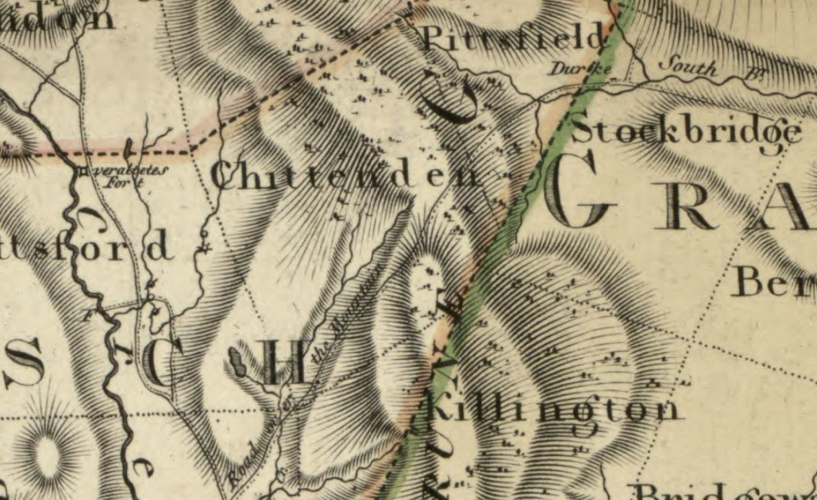 1796 View of Road Over the Mountain. From Vermont map by Bohn. found at: https://www.loc.gov/resource/g3750.tr000196/?r=0.205,0.744,0.265,0.117,0
3 Comments
Doug
6/26/2021 02:25:11 pm
This info satisfies some of my curiosities! We have friends that live close to Blackmer.
Illari
9/20/2021 07:30:11 am
Has anyone hiked the road or trail over the mountain / Elbow road recently?
ashley
12/4/2021 11:30:21 am
i have a friend who has a vehicle capable of going offroad, and that person is also a mountain biker. theyve driven the road before a gate was on it, and have mtn biked it as well. Your comment will be posted after it is approved.
Leave a Reply. |
AuthorI'm Bob Totz, retired VT postmaster, and historical geographer ARCHIVES:
October 2021
EXPANDED ARCHIVES: AUGUST 2021 1858 Johnson Map of North America MAY 2021 1795 - "Road Over the Mountain" - Part Two Historic Toll House For Sale 1795 - "Road Over the Mountain" Part One OCTOBER 2020 Finding That Special Peaceful Place AUGUST 2020 Kayaking on the Pompy JULY 2020 Pt. 2: What the Heck Are These Things? JUNE 2020 Bob's Bio... What the Heck Are These Things? Pt. 1 MAY 2020 Stone Walls and Spirits The View APRIL 2020 Sunny Brook Farm Relics: Pt 2. Sunny Brook Farm Relics: Pt 1. MARCH 2020 Signs of Norwich Pt. 2 COVID-19 Tracking Map Centertown and Valleyquest Signs of Norwich Pt. 1 "Imperfect Union" - Book Review Historic Centertown FEBRUARY 2020 King's Hwy Pt. 2 WRJ Museum at Post Mills Airport Chatauguay Vermont The Independent Farmer poem Traveling Along the King's Highway - Lebanon NH JANUARY 2020 Finding Parkhurst Cemetery In Search of Parkhurst Cemetery Affordable Housing The Old Stone Grill Two Rivers Trail-Kmart License and Registration, Please! Prohibition, Murder and Dr. Seuss Peace, Paris, & P.O. DECEMBER 2019 BLOGGER'S LINKS Welcome to Old Roads Love-Quail Hollow fun Dartmouth Cemetery SEPTEMBER 2019 E. Thetford Cemetery JUNE 2019
Taps: Meetinghouse Cemetery 4-Corners Borders Quest Old Iron Gate Stumbling Upon History Sunrise Walk MAY 2019 4 Corners Cemetery Strafford's Abandoned Foundations Art in Old Stonework APRIL 2019 Strafford Tpke Pt 2 Strafford Tpke Pt 1 White River Valley FEBRUARY 2019 Learning from Historic Maps of the Upper Valley Change in Lewiston VT JANUARY 2019 A Vermont Ski Waltz John Ledyard 1773 What is the Upper Valley? DECEMBER 2018 Dartmouth Green Music Video: Sometimes Music Video: Montreal Express Railway Disaster of 1887 |
 RSS Feed
