|
Welcome! Scroll Down for Posts and Archives.
Other Menu Options at Top |
|
|
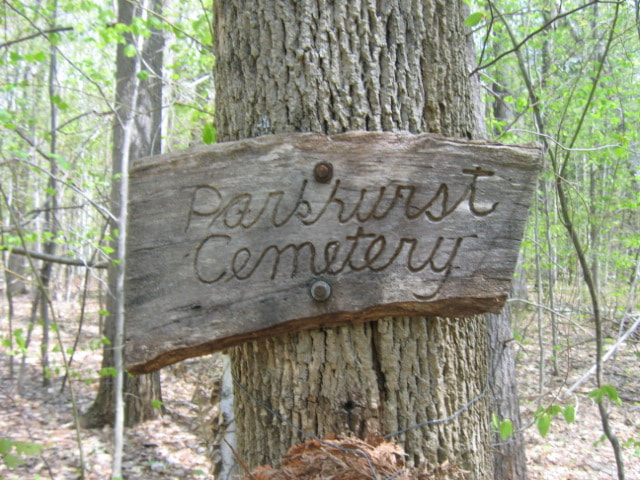 Sign at Parkhurst Cemetery. Photo Taken in 2008 Out in the "middle of nowhere" lies the Parkhurst Cemetery in Norwich, Vermont. It's one of those old graveyards, that you occasionally find out in the woods in the north country. Hunters, hikers, and snowmobilers are about the only folks who ever even go near the cemetery, whether they realize it or not. The 1855 Windsor County map by Walling indicates the graveyard with the word "Cem" not far from the Hartford town line, on a road that appears to be the extension of what is today known as "Happy Hill Road". 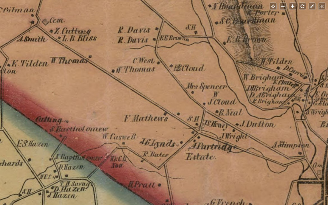 1855 View of Southwest Norwich, showing the Parkhurst Cemetery in the upper left corner, showed as a square, with "Cem" written next to it. Burials at Parkhurst Cemetery took place between the years of 1826 and 1873, according to findagrave.com. On the 1855 map view above, The town center of Norwich is in the lower right, where we see "Cem" referring to the Fairview Cemetery, where Alden Partridge, founder of Norwich University is buried. Heading out from there, you would take your first left, which is Bragg Hill Road, named after Dr. Bragg. Heading up Bragg Hill, you can see that the wandering line of Bragg Brook cross the road several times. When you get to the four corners, you see "A. Partridge Estate", and "S.H." S.H. indicates the Bragg Schoolhouse, that used to be at the narrow corner of Bragg Hill and Happy Hill roads. Continuing straight, on what is today, Happy Hill Road, you would pass the farms or homes of W. Thomas, on the right, followed by W. Thomas, on the left, while L.B. Bliss, and Z. Cutting's homesteads would be on the right, as you approach the intersection where the cemetery is indicated, (on the map above). The next map, below, shows a close-up view of the western corner of Norwich in 1855, when the area was still active. 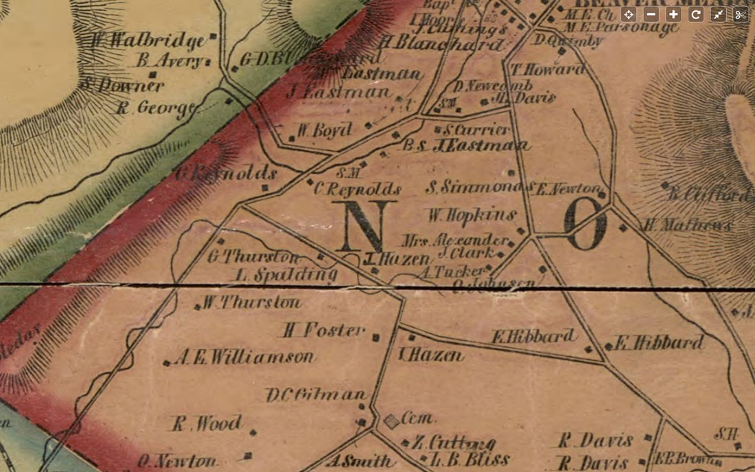 Close-up View, 1855. Parkhurst Cemetery is Center, Bottom. It's an area that is sparsely settled today, but holds clues to former activity in what is today, mostly forest, abandoned roads, and trails. Parkhurst Cemetery is in the center, bottom of the map above. In the map above, from the Parkhurst Cemetery, heading north, we get to a corner with "T. Hazen" on the right, and "H. Foster"on the left. This is most likely the corner of Sue Spaulding Road, and Burton Woods Road. Indeed, we can see that L. Spaulding had a place on Sue Spaulding Road. A right turn at this corner, would bring one back to Bragg Hill, west of Schoolhouse Road, and east of Tucker Hill Road. Bearing left on Sue Spaulding Road leads to Tigertown Road. Sue Spaulding and Burton Woods roads are old roads that have become trails. On the lower right, we see "S.H.", next to "E.B. Brown". That is the Brown Schoolhouse, on Schoolhouse road, which is also a trail. The next map, below is a modern topographic representation from alltrails.com 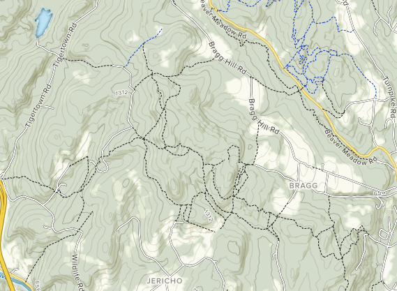 Map of Trails in Western Norwich, courtesy Alltrails.com Above, a modern topographic map of the larger area is shown, with trails indicated by dashed lines. It can be quite confusing, as some paths shown may be logging roads, or former trails. Below is another topographic view, from the 1927 USGS map, showing Tigertown Road, Sue Spaulding Road, Podunk Road, and a portion of Burton Woods Road. In addition, there is a double dashed line leading south from Sue Spaulding Road, that leads to the Podunk School. Perhaps this was a shortcut for the children to take to the Podunk Schoolhouse. It looks a lot steeper than the main route. Maybe the Spaulding children took their sleds in the winter, and went sledding part way to school and back! 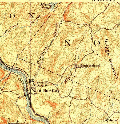 So....Which way to go? It appears there are 4 main ways to hike to the Parkhurst Cemetery. 1. Happy Hill Road to the AT South, to Burton Woods road. 2. Burton Woods Road (From Bragg Hill Road) 3. Sue Spaulding road to Burton Woods Road 4. Podunk Road, W. Hartford > Appalachian Trail > Burton Woods Rd. I've decided to take the third option, Sue Spaulding Road, which, appears to me to be the shortest and most direct route. Below is a google earth image of the route from Bragg Hill to Burton Woods. However, I've learned from experience, that the location of the cemetery may be a bit off from what is shown here. 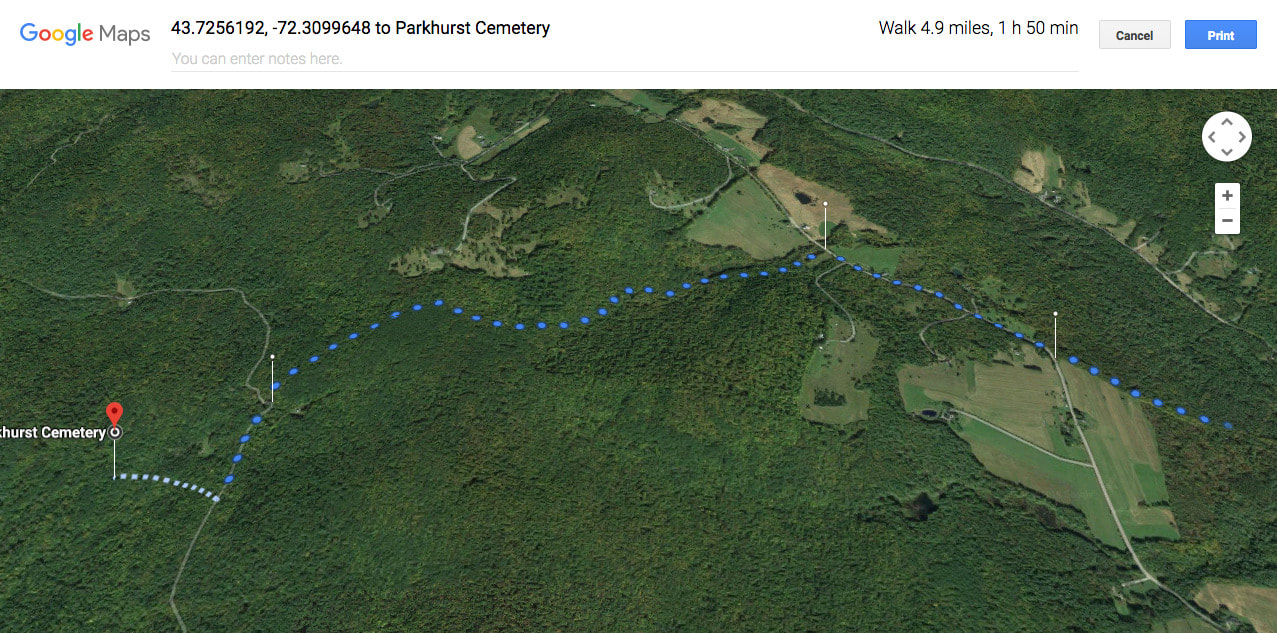 Bragg Hill > Burton Woods > Parkhurst Cemetery, courtesy Google Maps. It appears this is the longest route in, at 4.9 miles to the Parkhurst Cemetery. Below is the route I've decided to try. We'll park at the corner of Sue Spaulding Road, and Tigertown Road, and walk out Sue Spaulding. It looks like there's about a 300-400 foot gain in elevation, heading to the cemetery. Google Earth indicates a 6 minute trip, but I don't think they realize we don't really drive on these roads much anymore! 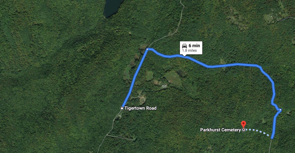 Tigertown > Sue Spaulding > Burton Woods > Parkhurst Cemetery. Photo courtesy Google Maps. As I write this, I'm waiting for a friend to call me about hiking to the Parkhurst Cemtery this afternoon, 1/28/2020. Below is a photo taken of the old graveyard in the woods, back in 2008. I'm hoping to find something similar out there soon, only 12 years later. I'll report back with my findings soon, hopefully! 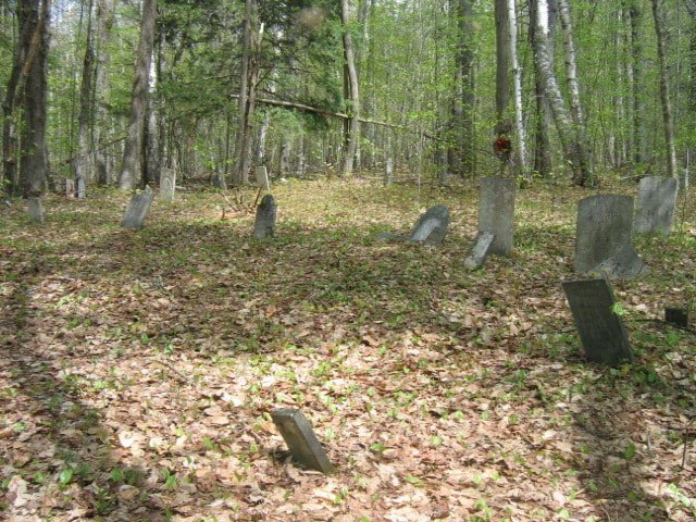 Parkhurst Cemetery in 2008. Photo taken by "AJ", courtesy of findagrave.com Thanks for hiking along Old Roads Rivers and Rails of the Upper Valley
with me, Bob Totz Feel free to check out some of our other adventures exploring old cemteries here: https://oldroadsuppervalley.weebly.com/cemeteries-upper-valley-vt-nh.html ...and our list of local trails here: oldroadsuppervalley.weebly.com/hiking-trails-upper-valley-vt-nh.html If you've not already subscribed, and woul like to join our club, (subscribe), and receive free email notices whenever we publish, please send an email to [email protected] and we'll add you to the group. Likewise, please share these articles with friends, and encourage them to subscribe. Thanks! - Bob Totz for oldroaduppervalley.weebly.com Sources: findagrave: https://www.findagrave.com/cemetery/104179/parkhurst-cemetery 1927 USGS map: ngmdb.usgs.gov/topoview/viewer/# Alltrails.com https://www.alltrails.com/explore/us/vermont/white-river-junction Google Maps: www.google.com/maps/dir/Parkhurst+Cemetery,+White+River+Junction,+VT+05001/Podunk+Rd,+Hartford,+VT+05001/@43.7125941,-72.3911362,1849a,35y,359.15h,45t/data=!3m1!1e3!4m14!4m13!1m5!1m1!1s0x4cb4cedfcda16e29:0xed527cf9907ae4f7!2m2!1d-72.3853606!2d43.7345666!1m5!1m1!1s0x4cb4ceeceb0bf135:0x350c7cff8f2604cd!2m2!1d-72.399434!2d43.720351!3e0
8 Comments
John Farrell
1/28/2020 01:28:38 pm
I’m on Turnpike Rd just before the pavement ends. I will be hiking out past Gile Mtn on the class 4 road which eventually takes you to an “intersection “ a beaver pond is on the left and an old graveyard is in this area. Have you been to it.?
Bob Totz
1/28/2020 05:36:06 pm
Yes, John. Here is a story I wrote last Spring, with photos. We hiked in from Chapel Hill, where the Beaver Pond is. Those are great hikes, with a great destination!
BA
1/28/2020 01:58:24 pm
Wow, that is intriguing! And really cool that it requires a hike to get there and is way off the beaten path. Hope you find it and I can't wait to read/see photos about it.
Bev Chapin
1/29/2020 03:57:36 am
Love those old maps, especially ones that included names of residents. Google maps are useful but not always accurate - need input from users. I sent corrections and saw them posted not long after once Google had time to verify the new info.
Bob Totz
1/29/2020 07:17:56 am
Google Earth seems to have this one wrong, but I'm hesitant to give them any info. I love these peaceful old cemeteries out in the woods. It's kind of nice to NOT know exactly where they are, but instead to enjoy the search!
Doug Eisler
6/14/2022 08:01:51 pm
Wow. I've walked these roads many times and haven't seen this graveyard yet. I will be looking out for it. Thanks!
Doug
6/25/2022 01:28:08 pm
Took me two tries, but I finally found it. Just a stones throw from where I have walked past a dozen times or so. It looksike someone put on some kind of white powder on some of the gravestones for some reason. Your comment will be posted after it is approved.
Leave a Reply. |
AuthorI'm Bob Totz, retired VT postmaster, and historical geographer ARCHIVES:
October 2021
EXPANDED ARCHIVES: AUGUST 2021 1858 Johnson Map of North America MAY 2021 1795 - "Road Over the Mountain" - Part Two Historic Toll House For Sale 1795 - "Road Over the Mountain" Part One OCTOBER 2020 Finding That Special Peaceful Place AUGUST 2020 Kayaking on the Pompy JULY 2020 Pt. 2: What the Heck Are These Things? JUNE 2020 Bob's Bio... What the Heck Are These Things? Pt. 1 MAY 2020 Stone Walls and Spirits The View APRIL 2020 Sunny Brook Farm Relics: Pt 2. Sunny Brook Farm Relics: Pt 1. MARCH 2020 Signs of Norwich Pt. 2 COVID-19 Tracking Map Centertown and Valleyquest Signs of Norwich Pt. 1 "Imperfect Union" - Book Review Historic Centertown FEBRUARY 2020 King's Hwy Pt. 2 WRJ Museum at Post Mills Airport Chatauguay Vermont The Independent Farmer poem Traveling Along the King's Highway - Lebanon NH JANUARY 2020 Finding Parkhurst Cemetery In Search of Parkhurst Cemetery Affordable Housing The Old Stone Grill Two Rivers Trail-Kmart License and Registration, Please! Prohibition, Murder and Dr. Seuss Peace, Paris, & P.O. DECEMBER 2019 BLOGGER'S LINKS Welcome to Old Roads Love-Quail Hollow fun Dartmouth Cemetery SEPTEMBER 2019 E. Thetford Cemetery JUNE 2019
Taps: Meetinghouse Cemetery 4-Corners Borders Quest Old Iron Gate Stumbling Upon History Sunrise Walk MAY 2019 4 Corners Cemetery Strafford's Abandoned Foundations Art in Old Stonework APRIL 2019 Strafford Tpke Pt 2 Strafford Tpke Pt 1 White River Valley FEBRUARY 2019 Learning from Historic Maps of the Upper Valley Change in Lewiston VT JANUARY 2019 A Vermont Ski Waltz John Ledyard 1773 What is the Upper Valley? DECEMBER 2018 Dartmouth Green Music Video: Sometimes Music Video: Montreal Express Railway Disaster of 1887 |
 RSS Feed
