|
Welcome! Scroll Down for Posts and Archives.
Other Menu Options at Top |
|
|
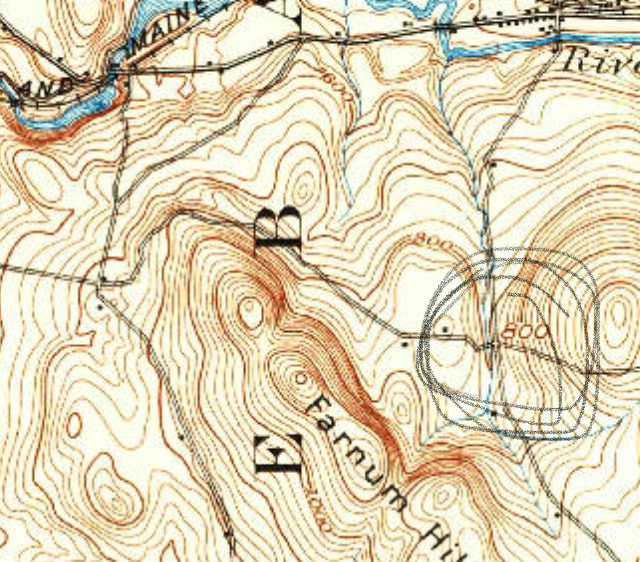 A Portion of The Old King's Highway, Lebanon. NH, winding north and west around Farnum Hill. 1932 USGS 15 min. series, Hanover Quadrangle. Circled is Intersection with Slayton Hill Road. Portions of The "King's Highway", or "The Old King's Highway" show up in various places in New Hampshire and Vermont. I first noticed it when looking at older maps of the Poverty Lane area of New Hampshire, from before the Lebanon Airport was built. I found it interesting that there was a King's HIghway in both Lebanon, NH, and also just across the Connecticut River in Hartford, Vermont. In Lebanon, the "Old King's Highway" came in from the east, from the Storrs Hill area, crossing Slayton Hill Road, heading up hill going west into Farnum Hill. 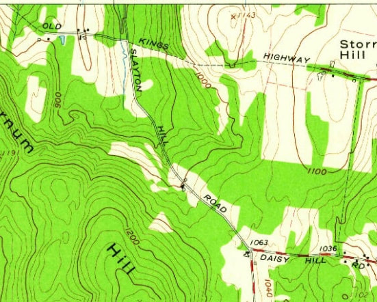 Old King's Highway in Lebanon, shown at top. While Mostly a Trail, One portion is maintained, just west of the Intersection with Slayton Hill Road. Eastern Portion Heads Toward Storrs Hill. From the 1959 USGS 7.5 Minute Series North Hartland Map. Awhile back, I took a trip east on the Miracle Mile, to investigate the Old King's Highway. Just before the center of Lebanon, I took a right up Slayton Hill Road, a road I'd passed by many times, but had only traveled on once or twice before. 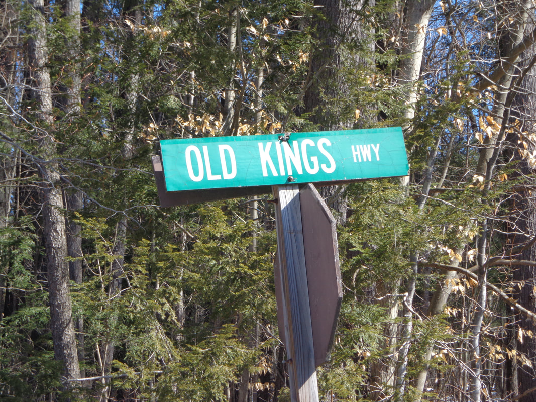 Sign at the corner of Slayton Hill Road, Storrs Hill Road, and Old King's Highway, (a.k.a. Farnum Hill Road). After winding my way up Slayton Hill for a while, I came to the intersection with Storrs Hill Road, which was to my left. To the right, uphill, was "Old King's Highway" However, if you look at the area on google maps, that section of the road is labeled Farnum Hill Road. I headed up Old King's Highway, and found a beautiful stately old home situated on a knoll. The home was in the process of receiving new windows, and probably siding too. It was a beautiful spot, and spoke of a simpler time, long ago. Just beyond where the maintained portion of the old road ends, the Old King's Highway becomes a trail in the woods, with massive stone walls on either side of a wide roadway. There's a kiosk located there, where the modern road ends, but the Old King's Highway continues on, around the northern boundary of the Farnum Reserve. 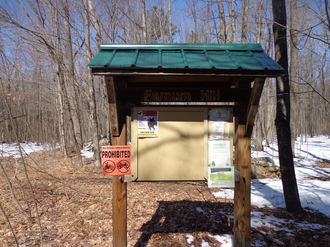 Kiosk at the Beginning of the Old King's Highway Trail in Lebanon NH I headed down the Old King's Highway for a walk. It was quiet and calm, and I could imagine the old horse drawn wagons clip-clopping down the wide lane. 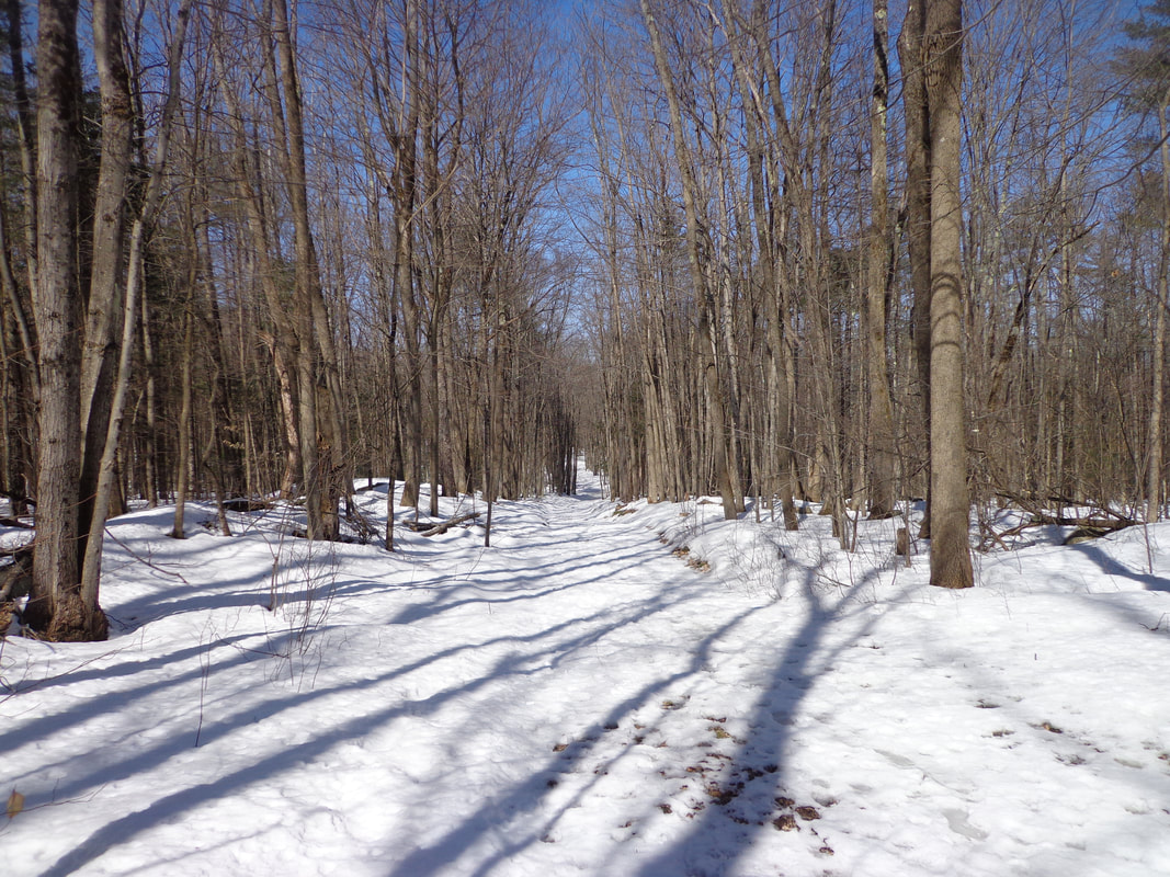 The Old King's Highway, at Farnum Hill, in Lebanon. Here is a quote from the official Lebanon New Hampshire website: "The area around Farnum Hill is rich in early Lebanon History. King's Highway, the first planned colonial road in Lebanon is now a class VI road running along the north boundary of the reserve. Original planners proposed that the first village in Lebanon be built in the north slopes of Farnum Hill. However, early settlers chose other sites for their first villages" As I headed back out of the woods, and returned to Slayton Hill Road, I eventually came to a fork, took a right, and found myself on Poverty Lane, a road I'd been on before, though many years ago. As I continued driving along Poverty Lane, I eventually came to a spot where the King's Highway Trail came out of the woods on the other end of the Farnum Hill Reserve, not far from Poverty Lane Orchards. It's great that this section of Lebanon's oldest colonial road is available for hiking today. While searching for old maps of Lebanon with the Old King's Highway on them, I found an interesting 1884 "Bird's Eye View" map of the center of Lebanon, from the Library of Congress website. I place it here, though it does not show the King's Highway area, which would have been a bit to the south. 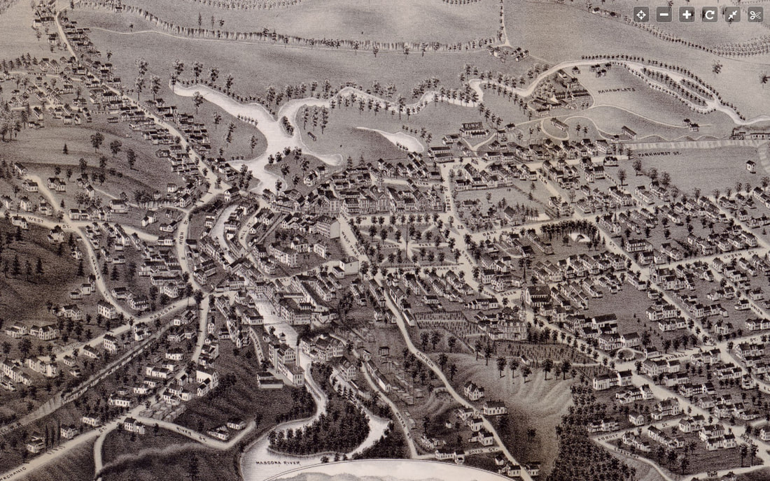 Bird's Eye View of Lebanon New Hampshire, 1884. found at: https://www.loc.gov/resource/g3744l.pm011600/?r=0.017,0.229,0.949,0.381,0 Below is the imagery from the 1860 Grafton County, NH map by Walling: 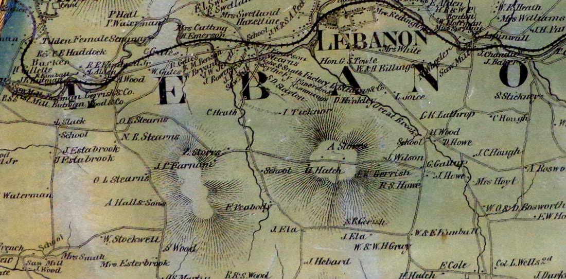 In the 1860 view above, we can see where the name "Farnum Hill" came from. Farnum lived along the Old King's Highway, along wih Z. Storrs, near the area that I walked, not far from Slayton Hill Road. If you followed the Old King's Highway in 1860, you'd get to an intersection near O.L. and N. B. Stearns, where Old King's Highway meets Poverty Lane on the west side of Farnum Hill. Continuing west, towards where the airport stands today, there was a school near L. Slack's place. The road continued west, down towards what is now Route 12A. Below is a similar view, almost one hundred years later, from 1959, with the Old King's Highway still in view as a trail. 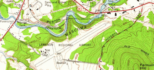 Farnum Hill, Old King's Highway, and the Lebanon Airtport. 1959 7.5 Minute Series USGS Hanover Quadrant. In researching online about the King's Highway, you'll find a few real estate ads, and some history about the original King's Highway that King Charles II ordered built in 1650, from Charleston. South Carolina to Boston Mass. The original highway was extended through Hampton and Portsmouth, New Hampshire, to Portland, Maine. Apparently there were many King's Highways, King's Ways, and King's Roads in the colonial era. One was built from Keene, New Hampshire to the seacoast, starting in 1747, through Merrimack, NH. There is an interesting "Church Map" available, courtesy Dartmouth College Libraries. Here is the top of the map. I haven't found much out about this map yet, but it appears that the bold lines were sections known as "King's Highways", Which could be used as a route to get to church. Strangely enough, the Old King's Highway in Lebanon is not shown boldly, presumably because it was more of a trail than a road at that point in time, around 1925. 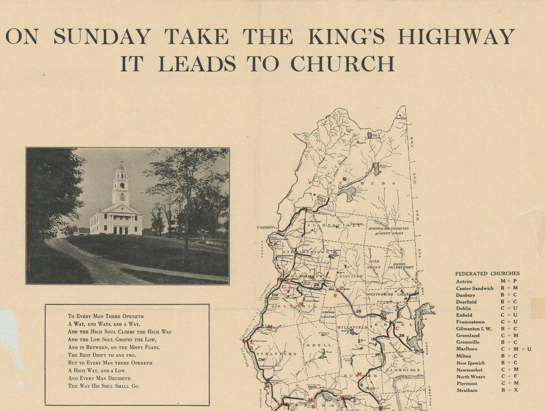 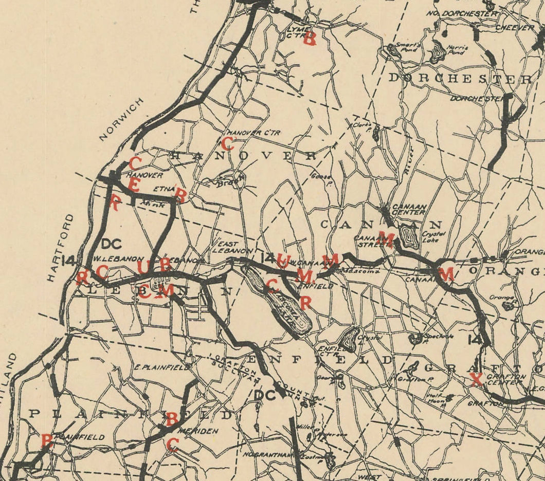 Close-up View Showing Lebanon, Hanover, Plainfield, Enfield and Canaan NH. "Church Map" Prepared by the Interdenominational Commission of New Hampshire, 1925 Courtesy Dartmouth College Libraries An old timer once told me that a King's Highway went from Boston to Montreal, via Lebanon and White River Junction, and Montpelier. I suppose travelers in the earliest days did well to get a ferry across the Connecticut River, either at Lyman Point, or maybe a little further south. I also read that back in Colonial Times, a road might be reviewed by a royal committee, and if found to be good enough, it was deemed "The King's Highway". The following is an excerpt from The Road North of Boston, New Hampshire Taverns and Turnpikes, 1700-1900: "In 1743, for example, the legislature sent a committee 'to goe up to Chester and Londonderry to View a high way formerly laid out.' Only after the committee reported the road to be 'the most conveniente way for Accomodation of Both Towns and Travellers in General' did the committee proclaim it "the King's Highway and...a Publick road' " By being proclaimed "The King's Highway" the road was available to be maintained at town expense. I guess if the road passed the review, then it was good enough for the king to travel on. There's a small section of a King's Highway in Hartland, VT too. Here's a 1959 view of the King's Highway in Hartford Vermont, in the Hurricane Hill area, as seen below: 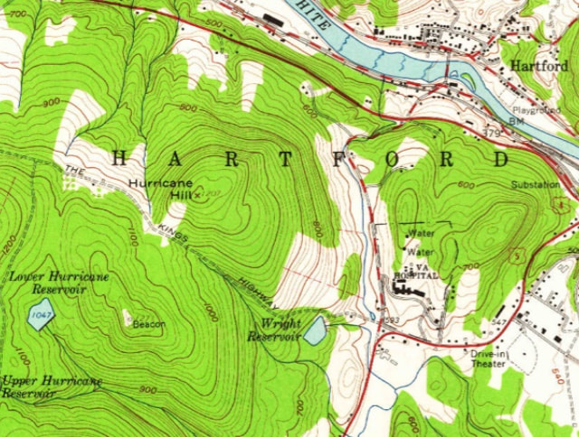 King's Highway in White River Junction, or Hartford, Vermont, Heading Northwest from Wright Reservoir Area. 1959 USGS 7.5 Minute Series, Hanover NH Quadrant There's also a section of King's Highway in Pomfret, VT, not far from the Bunker Hill Cemetery and the Appalachian Trail. 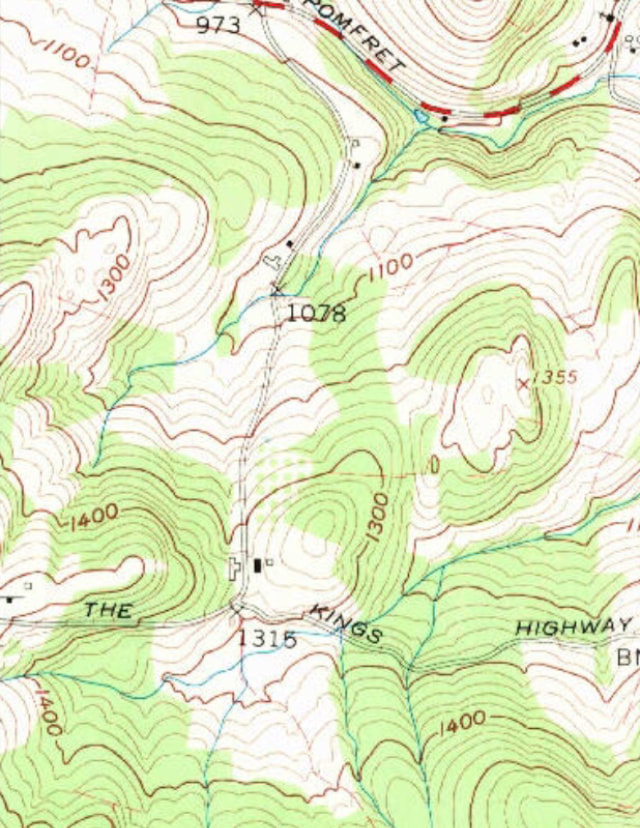 King's Highway in Pomfret, Vermont 1959 7.5 Minute Series, USGS Quechee Quadrangle I recently spent some time trying to find what would have been the most likely route to Montpelier from White River Junction around 1820 or so, while searching for segments of the old King's Highway. I mapped out an interesting trip, that would be fun to try to travel today. There are some beautiful old roads along the ridges and valleys of Vermont, awaiting exploration.
Thanks for traveling along on Old Roads, Rivers and Rails of the Upper Valley. - Bob Totz USGS Map Source: ngmdb.usgs.gov/topoview/viewer/#4/39.98/-100.06 King's Highway through Merrimack, NH: www.merrimacknh.gov/highway-maintenance/pages/old-kings-highway Interesting "Church" map of King's Highways: http://libarchive.dartmouth.edu/cdm/singleitem/collection/gsmaps/id/1243/rec/1 Lebanon NH Official Website on Farnum Hill Reserve: https://lebanonnh.gov/Facilities/Facility/Details/Farnum-Hill-Reserve-26 Book: The Road North of Boston: New Hampshire Taverns and Turnpikes 1700-1900. authors: Donna-Belle Garvin and James L. Garvin. published by University Press of New England, Hanover and London.
5 Comments
suzi r
2/9/2020 09:29:45 am
Bob, what a wonderful read first thing on this bitter-cold Sunday morning! Thank you for an armchair travelogue of some fascinating places in our Valley--the sort of places that trigger questions in my mind as I drive by them. As always, I love the maps--so much info in a short space. Happy trails! to you
Bob Totz
2/9/2020 07:25:03 pm
Happy Trails to you too, Suzi!
B A
2/10/2020 10:01:06 am
Very interesting! I used to live in the neighborhood of Kings Highway in Hartford, and did wonder about the history of it. There is a neat old cemetery at the corner of Kings Highway and Center of Town Rd. Like you said, I could picture horses and wagons and times gone by. 2/10/2020 08:06:02 pm
Hi Bob,
Casey B
8/20/2022 10:41:50 pm
Hi Bob, your research is absolutely fascinating. I would love to draw upon your knowledge for some additional questions I have about Old Kings Highway in the early 1800s. Incidentally, my family and I live in the old farmhouse on Farnum Hill Road you referred to. Renovations are still in progress but we’ve made some headway since your write-up! Thanks again for sharing. Your comment will be posted after it is approved.
Leave a Reply. |
AuthorI'm Bob Totz, retired VT postmaster, and historical geographer ARCHIVES:
October 2021
EXPANDED ARCHIVES: AUGUST 2021 1858 Johnson Map of North America MAY 2021 1795 - "Road Over the Mountain" - Part Two Historic Toll House For Sale 1795 - "Road Over the Mountain" Part One OCTOBER 2020 Finding That Special Peaceful Place AUGUST 2020 Kayaking on the Pompy JULY 2020 Pt. 2: What the Heck Are These Things? JUNE 2020 Bob's Bio... What the Heck Are These Things? Pt. 1 MAY 2020 Stone Walls and Spirits The View APRIL 2020 Sunny Brook Farm Relics: Pt 2. Sunny Brook Farm Relics: Pt 1. MARCH 2020 Signs of Norwich Pt. 2 COVID-19 Tracking Map Centertown and Valleyquest Signs of Norwich Pt. 1 "Imperfect Union" - Book Review Historic Centertown FEBRUARY 2020 King's Hwy Pt. 2 WRJ Museum at Post Mills Airport Chatauguay Vermont The Independent Farmer poem Traveling Along the King's Highway - Lebanon NH JANUARY 2020 Finding Parkhurst Cemetery In Search of Parkhurst Cemetery Affordable Housing The Old Stone Grill Two Rivers Trail-Kmart License and Registration, Please! Prohibition, Murder and Dr. Seuss Peace, Paris, & P.O. DECEMBER 2019 BLOGGER'S LINKS Welcome to Old Roads Love-Quail Hollow fun Dartmouth Cemetery SEPTEMBER 2019 E. Thetford Cemetery JUNE 2019
Taps: Meetinghouse Cemetery 4-Corners Borders Quest Old Iron Gate Stumbling Upon History Sunrise Walk MAY 2019 4 Corners Cemetery Strafford's Abandoned Foundations Art in Old Stonework APRIL 2019 Strafford Tpke Pt 2 Strafford Tpke Pt 1 White River Valley FEBRUARY 2019 Learning from Historic Maps of the Upper Valley Change in Lewiston VT JANUARY 2019 A Vermont Ski Waltz John Ledyard 1773 What is the Upper Valley? DECEMBER 2018 Dartmouth Green Music Video: Sometimes Music Video: Montreal Express Railway Disaster of 1887 |
 RSS Feed
