|
Welcome! Scroll Down for Posts and Archives.
Other Menu Options at Top |
|
|
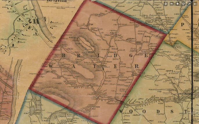 Bridgewater Vermont, 1855 Windsor County wall map by Hosea Doton. Have you heard of, or been to Chatauguay? Chatauguay is an old settlement in the northwest corner of Bridgewater Vermont. Bridgewater lies just west of Woodstock, Vermont and can be found on the way to Killington and Rutland on U.S. Route 4, although the Chatauguay area is closer to Barnard. Below is a close-up from the 1855 map. The name Briggs appears, along with a schoolhouse and Saw Mill at the confluence of two streams in Chatauguay. In this early view, we can clearly see two roads, one leading west, into Sherburne, (and Rutland County), and the other leading north and northeast, into Barnard. As you can see, above the Briggs Family, the road crossed the brook many times, on the way to the next neighbor, Thompson, and there was even another schoolhouse, up near the township boundary with Barnard. 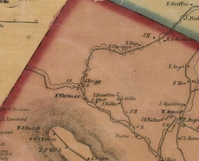 Below is a topographic map view from the 1930's. By then there were three roads leaving the area labeled Chatauguay, and they were all unmaintained roads at this point. 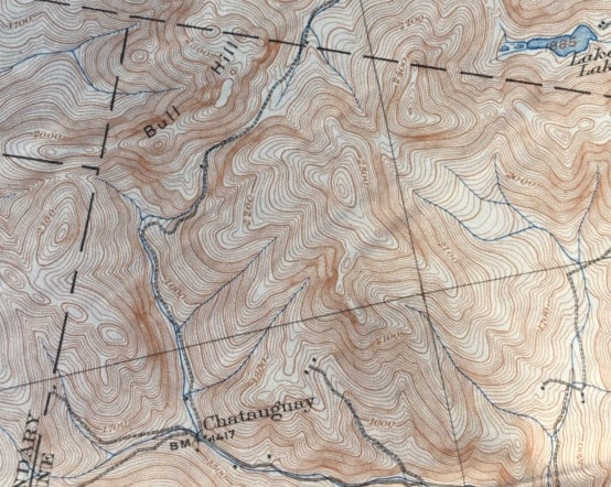 Below is a 1943 view; USGS imagery, which shows even more unimproved roads in the area, and a few dwellings or camps near the base of Bull Hill, in the nort-central area of this photo: 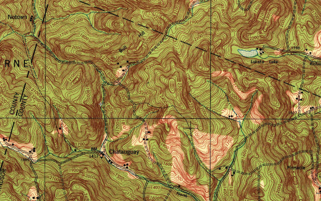 The above map is from the 1:62,500 or "15 Minute" series USGS map. Below is a similar view, but from the 7.5 minute series map, from 1966. On this map we see the unimproved road turned into a single dashed line, or "Jeep Trail". Also, a portion of the Appalachian Trail has appeared. 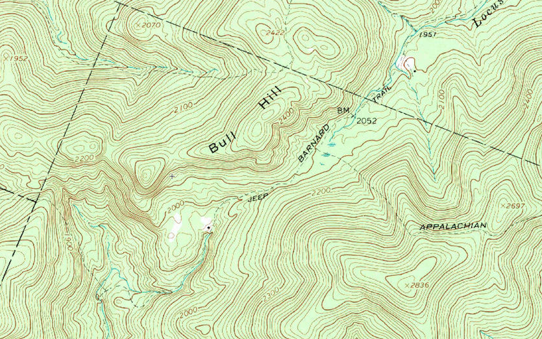 There's a spot on the map above, just above the word "Jeep" where the terrain narrows, with sloping sides, at an elevation of about 2100 feet. Just beyond that, to the northeast, there's a marshy area, before descending on the north side. This looks like an interesting area to do some field checking in the future. It was recently suggested I look into the history of the roads of Bridgewater, particularly the roads that became discontinued sometime in the last couple hundred years. Often those roads provide clues to early settlement along the way. Stone walls and old foundations can often be found. Farm houses, barns, mills, and outbuildings that once served the humble settlers of these townships, in many instances fell into disrepair and disuse, and simply decomposed back into the earth, leaving only the stones upon which they were built. 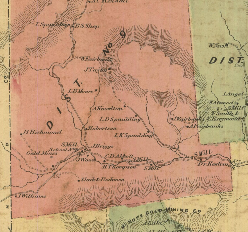 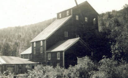 The above map is from the Beers Atlas, around 1869. By this time gold had been found, and the northwest region of Bridgewater was quite active. The gold mini-boom provided a romantic period in the history of Bridgewater Vermont. "Goldcrusher" Building, circa 1902 While doing some internet research for this post, I came upon the following great video posted by Kristina Stykos. It features a road trip in the Chatauguay, using their "trusty gazetteer" for navigation. If you want to get a good feel for what it's like to travel in that remote area, by car, in the 21st century, click on this link:
I'ts Just a Mile Down the Road Following is another video, which gives an idea what it would be like to travel out the old Chatauguay Road today in a caravan of modern Jeeps! It's an interesting video to watch, especially after studying the topography and map images of the area. 2016 Killington Jeep Jamboree - Friday, Chatauguay There are some other interesting areas in Bridgewater that I'd like to explore in the near future. Places with names like "Grandmadam Hill", "Dailey Hollow", and "Bridgewater Hollow" For now, I'm just looking forward to a nice hike up into Chatauguay, but I don't think I'll take my Jeep too far up in there! Thanks for traveling down Old Roads, Rivers and Rails of the Upper Valley. - Bob Totz Map Sources: 1855 Windsor County Map by Hosea Doton: https://www.loc.gov/resource/g3753w.la001193/?r=0.28,0.423,0.138,0.053,0 USGS maps: https://ngmdb.usgs.gov/topoview/viewer/#4/40.00/-100.00 "Goldcrusher" Building courtesy Bridgewater Historical Society: http://www.bridgewaterhistory.org/projects/gold-crusher/
8 Comments
John Farrell
2/16/2020 07:34:02 am
Great description of Chatauguay. I’ve hiked a bit up there and now want to do so again this summer. If you can obtain a copy of the history of Sherburne VT you will find many references to Chatauguay.....gold mining, farmers hiding their stock up in Chatauguay to avoid taxes etc. Thanks for this post.
Bob Totz
2/16/2020 08:16:09 pm
Thanks John. Maybe our library can find a copy
Douglas Shane
2/16/2020 12:55:29 pm
When I lived outside Barnard, 1991-97, I was one of a few who saw a catamount. Yes, an adult mountain lion! Once, crossing a road, slowly, visible in my headlights on a Friday night in winter, (When I reported the sighting to VINS the following Monday I was told that they were aware of sightings and "please don't broadcast the news."
Bob Totz
2/16/2020 07:05:34 pm
Thanks so much for sharing your stories, Douglas Shane!
Robert Cota
2/16/2020 07:38:35 pm
Bob you are doing a great job and some of these towns I have never heard off before.
Bob Totz
2/16/2020 08:18:33 pm
Thanks, Robert.
Bob Totz
2/22/2020 08:39:22 am
A good friend wrote this to me: "So Chatauguay- Ive been Lost up there several times. even seriously lost a couple times. Such an easy place to get turned around in. I havnt checked out your links yet But yes there are sevral good ways in( but harder to find a way out)- There is the N. bridgewater. rd off rt 4, or from the north in stockbridge/gaysville area runs i think its called stonybrook rd. Of course my favorit way is through pomfert up a different stony brook rd to the old appalacian trail via a wonderful spot called Luces lookout up in the Greengate area. or you can head further north of barnard & take the old chataguay road a few miles which in theory could connect you to the old bridgewater rd. . I guess we should sit down with the maps soon, cause as i said despite having hiked up there a bunch i Have gotten seriously Lost as well as walked in big circles several times up there. But that all fits in with the great Chatauguay myth or myths - gold seems to always leads to myths-. ...... though i did leave the actual story details out of the several times i got Lost in chatauguay & some of them are pretty funny....Its amazing how many times ive been so called lost in the woods or desert or.... but lost is a concept , i tend to see it as I am not Lost I just have no clue where i am or how to get back to where i was, but thats what makes it an adventure. Of course since i refuse to hike with a compass, prefer to get off the trail & often dont carry a detailed map, Have no clue how to use a GPS- I guess i get what i ask for- And sometimes Love it, often Curse myself for being so foolish, But always seem to find my way back to where i started the hike..... And yes chatauguay is a great spot for doing such. There is a bunch of Folk lore that goes with that region Too. though i dont recall any of the specifics, would make a good research project. Let me know if you come across any of the old myths...."
David Martin
2/8/2021 06:06:49 pm
Does anyone know how Chatauguay got its name? Your comment will be posted after it is approved.
Leave a Reply. |
AuthorI'm Bob Totz, retired VT postmaster, and historical geographer ARCHIVES:
October 2021
EXPANDED ARCHIVES: AUGUST 2021 1858 Johnson Map of North America MAY 2021 1795 - "Road Over the Mountain" - Part Two Historic Toll House For Sale 1795 - "Road Over the Mountain" Part One OCTOBER 2020 Finding That Special Peaceful Place AUGUST 2020 Kayaking on the Pompy JULY 2020 Pt. 2: What the Heck Are These Things? JUNE 2020 Bob's Bio... What the Heck Are These Things? Pt. 1 MAY 2020 Stone Walls and Spirits The View APRIL 2020 Sunny Brook Farm Relics: Pt 2. Sunny Brook Farm Relics: Pt 1. MARCH 2020 Signs of Norwich Pt. 2 COVID-19 Tracking Map Centertown and Valleyquest Signs of Norwich Pt. 1 "Imperfect Union" - Book Review Historic Centertown FEBRUARY 2020 King's Hwy Pt. 2 WRJ Museum at Post Mills Airport Chatauguay Vermont The Independent Farmer poem Traveling Along the King's Highway - Lebanon NH JANUARY 2020 Finding Parkhurst Cemetery In Search of Parkhurst Cemetery Affordable Housing The Old Stone Grill Two Rivers Trail-Kmart License and Registration, Please! Prohibition, Murder and Dr. Seuss Peace, Paris, & P.O. DECEMBER 2019 BLOGGER'S LINKS Welcome to Old Roads Love-Quail Hollow fun Dartmouth Cemetery SEPTEMBER 2019 E. Thetford Cemetery JUNE 2019
Taps: Meetinghouse Cemetery 4-Corners Borders Quest Old Iron Gate Stumbling Upon History Sunrise Walk MAY 2019 4 Corners Cemetery Strafford's Abandoned Foundations Art in Old Stonework APRIL 2019 Strafford Tpke Pt 2 Strafford Tpke Pt 1 White River Valley FEBRUARY 2019 Learning from Historic Maps of the Upper Valley Change in Lewiston VT JANUARY 2019 A Vermont Ski Waltz John Ledyard 1773 What is the Upper Valley? DECEMBER 2018 Dartmouth Green Music Video: Sometimes Music Video: Montreal Express Railway Disaster of 1887 |
 RSS Feed
