|
Welcome! Scroll Down for Posts and Archives.
Other Menu Options at Top |
|
|
|
Originally Published May 2019.  If These Walls Could Talk. An abandoned old rock wall foundation, humble yet majestic, near a route I used to take often, had finally caught my attention. I used to catch a glimpse of it, only if the season was right, and the light was right too. Most times it was an almost unconscious glimpse, until it eventually became a conscious reminder that something from the past was calling my attention. Today I pulled over and parked, and started walking to get a better look. 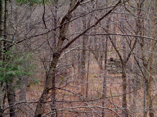 Stone foundation in the woods seen from a distance. As I approached closer, I could get a better look at an old stone foundation. 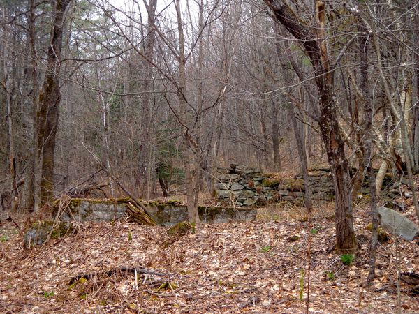 I realized I was following the beginning of the Ballard Trail. 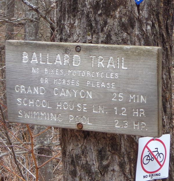 Here are some photos of the foundation walls that I saw. The first one is of some large moss covered stones at one corner. 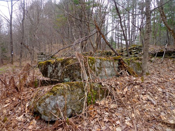 Large Stones at one corner of the Old FoundationThe moss on the rocks greens up quickly this time of year, making the old foundation more noticeable than at other times when it's covered in snow, or hidden by greenery I decided to put my camera down near the fiddleheads that were cropping up. 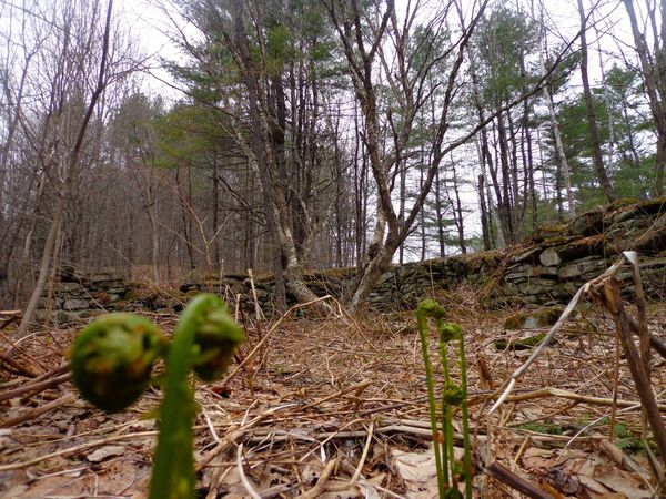 Between the fiddleheads, in the background, there is a mature Yellow Birch tree with several trunks that found an agreeable spot in the old cellar hole. Here is a closer look at the Yellow Birch tree, and the walls in the background. The stones seem masterfully laid. 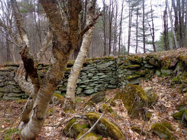 Below is a close-up of one of the stone walls. I like to think about who the people were who put them there, in that arrangement, and how much work that took to accomplish. What tools did they use to position the heavy rocks? Where were those tools made, and sold? How many people did it take to build the foundation, and how long did it take? This wall has bowed out a bit, with time and snow and rain and frost and thaws. I wonder what year these walls were built, and what type of building they held up. Was it a home? maybe a barn, or a shed? Do you see a face in there, or is it just me? To me it looks like Oscar the Grouch! 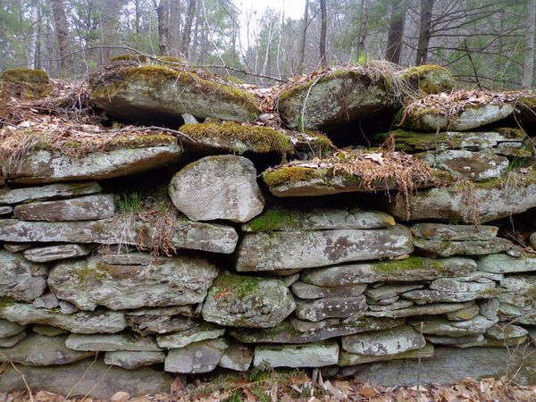 Do you see Oscar the Grouch? Here's a few more shots of these beautifully laid stone walls: 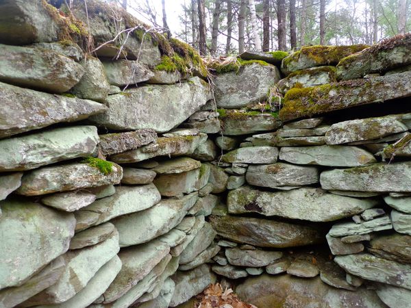 Nice corner, laid there many years ago. The corners were astonishingly tight, though one wall had bulged out. Here's a nice hole in the wall. I wonder if anyone ever hid anything in the cellar walls? 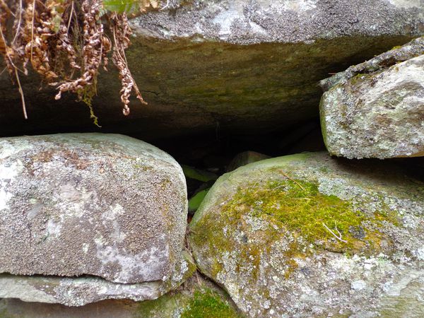 Here's a shot with the crazy 4-trunked yellow birch tree: 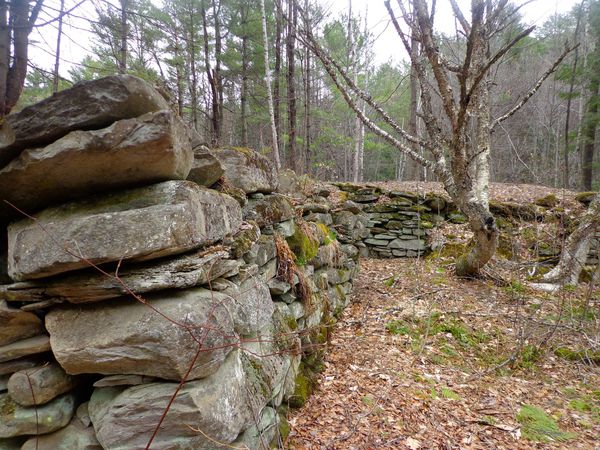 And a shot of the back of the far wall: 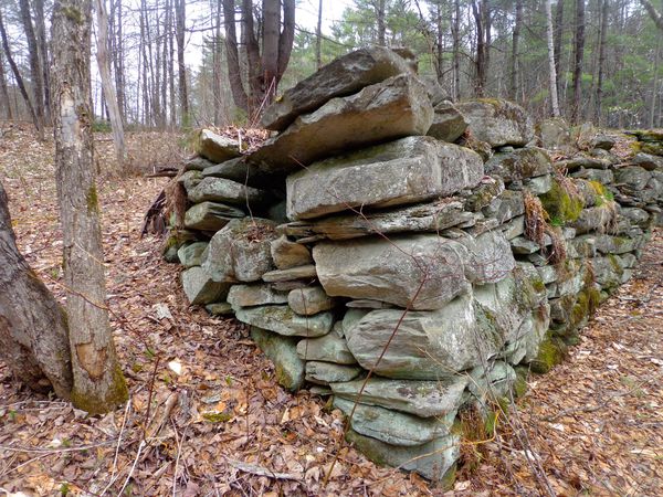 The Ballard Trail took me over a small bridge over a brook. I could see what looked to me to have been a small mill site, or maybe a springhouse, by the formation of the wall under the bridge. 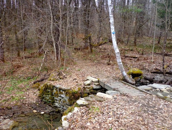 Possible old Mill or Springhouse site on the Charles Brown Brook. When I got closer to the bridge, I could see that the stone walls here must have been made very well, to have weathered the ravages of time, though they may have been shored up by the kind folks who built the bridge over the trail at one point. 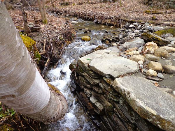 Above, we see the water was still being channeled well, through the old sluice, though a white birch tree had taken up residence at the entrance! 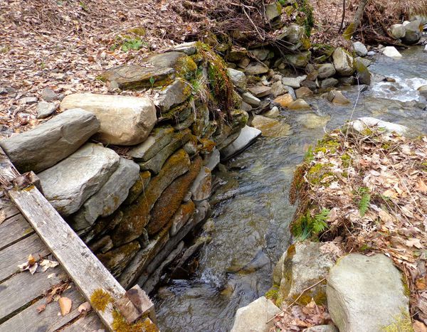 Brook flowing out of the channel, narrowed by the stone wall. After I returned home, I decided to see if there were any clues on any maps that I could find. The first one I went to was the 1855 Windsor County map. "H. Mathews" was the only name on the only dwelling near to this location, as near as I could tell, at least around 1855. 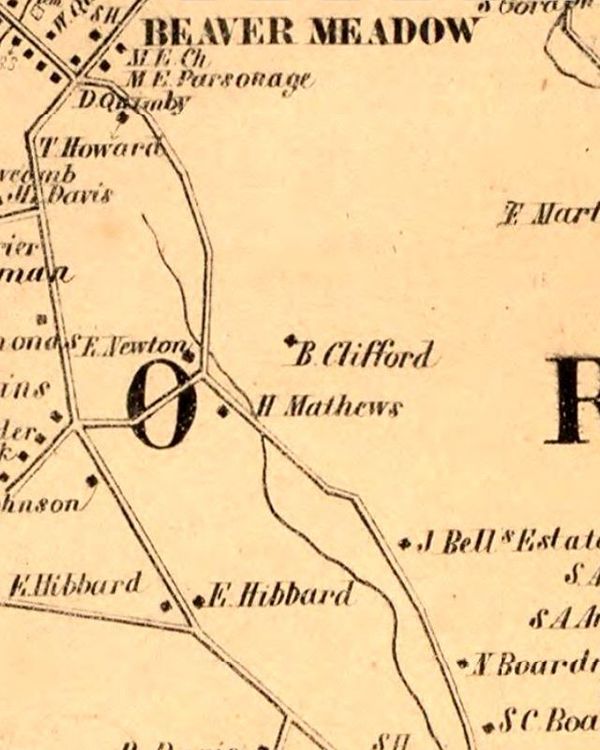 Charles Brown Brook along Beaver Meadow Road. Also Bragg Hill and Tucker Hill Roads. From 1855 I jumped to the 1896 USGS map: 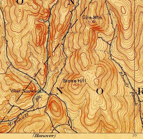 1896 USGS Topographic Map, Strafford Quadrangle Checking the 1896 USGS map, seen above, (bottom, center), and below, blown up, we can see two houses near the bottom of Tucker Hill Road. They were listed as "Newton" and "H. Mathews" on the 1855 map. The Newton house is still standing, and I've been told it's one of the oldest houses in Norwich, and that it used to be a stagecoach stop. 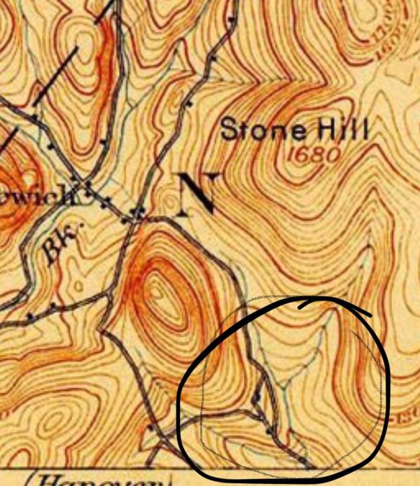 Tucker Hill and Beaver Meadow Intersections. The road that passed above the Newton house is no longer there, and today, there is no house at the bottom of Tucker Hill Road. On the 1896 map above, the building shown on the bottom of Tucker Hill could represent a home built on the old foundation that I saw. Jumping ahead another fifty years, to the 1944 USGS map below, we can see there is no house or building shown at the bottom of Tucker Hill Road. So sometime between 1896 and 1944, it looks like that house disappeared. 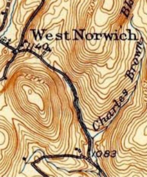 Tucker Hill and Beaver Meadow Roads, 1944 USGS map. Source of Charles Brown Brook, West Norwich, Vermont.
0 Comments
Your comment will be posted after it is approved.
Leave a Reply. |
AuthorI'm Bob Totz, retired VT postmaster, and historical geographer ARCHIVES:
October 2021
EXPANDED ARCHIVES: AUGUST 2021 1858 Johnson Map of North America MAY 2021 1795 - "Road Over the Mountain" - Part Two Historic Toll House For Sale 1795 - "Road Over the Mountain" Part One OCTOBER 2020 Finding That Special Peaceful Place AUGUST 2020 Kayaking on the Pompy JULY 2020 Pt. 2: What the Heck Are These Things? JUNE 2020 Bob's Bio... What the Heck Are These Things? Pt. 1 MAY 2020 Stone Walls and Spirits The View APRIL 2020 Sunny Brook Farm Relics: Pt 2. Sunny Brook Farm Relics: Pt 1. MARCH 2020 Signs of Norwich Pt. 2 COVID-19 Tracking Map Centertown and Valleyquest Signs of Norwich Pt. 1 "Imperfect Union" - Book Review Historic Centertown FEBRUARY 2020 King's Hwy Pt. 2 WRJ Museum at Post Mills Airport Chatauguay Vermont The Independent Farmer poem Traveling Along the King's Highway - Lebanon NH JANUARY 2020 Finding Parkhurst Cemetery In Search of Parkhurst Cemetery Affordable Housing The Old Stone Grill Two Rivers Trail-Kmart License and Registration, Please! Prohibition, Murder and Dr. Seuss Peace, Paris, & P.O. DECEMBER 2019 BLOGGER'S LINKS Welcome to Old Roads Love-Quail Hollow fun Dartmouth Cemetery SEPTEMBER 2019 E. Thetford Cemetery JUNE 2019
Taps: Meetinghouse Cemetery 4-Corners Borders Quest Old Iron Gate Stumbling Upon History Sunrise Walk MAY 2019 4 Corners Cemetery Strafford's Abandoned Foundations Art in Old Stonework APRIL 2019 Strafford Tpke Pt 2 Strafford Tpke Pt 1 White River Valley FEBRUARY 2019 Learning from Historic Maps of the Upper Valley Change in Lewiston VT JANUARY 2019 A Vermont Ski Waltz John Ledyard 1773 What is the Upper Valley? DECEMBER 2018 Dartmouth Green Music Video: Sometimes Music Video: Montreal Express Railway Disaster of 1887 |
 RSS Feed
