|
Welcome! Scroll Down for Posts and Archives.
Other Menu Options at Top |
|
|
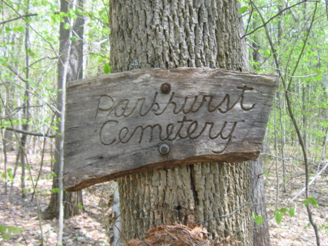 Sign at Parkhurst Cemetery. Photo Taken in 2008 Out in the "middle of nowhere" lies the Parkhurst Cemetery in Norwich, Vermont. It's one of those old graveyards, that you occasionally find out in the woods in the north country. Hunters, hikers, and snowmobilers are about the only folks who ever even go near the cemetery, whether they realize it or not. The 1855 Windsor County map by Walling indicates the graveyard with the word "Cem" not far from the Hartford town line, on a road that appears to be the extension of what is today known as "Happy Hill Road". 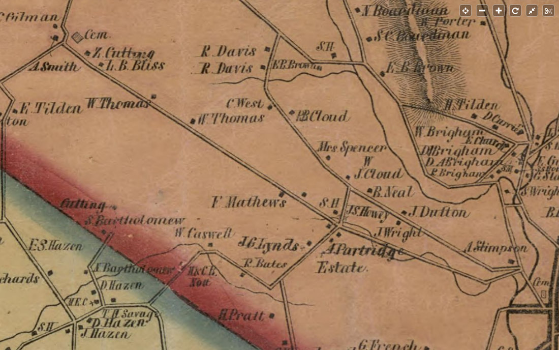 1855 View of Southwest Norwich, showing the Parkhurst Cemetery in the upper left corner, showed as a square, with "Cem" written next to it. Burials at Parkhurst Cemetery took place between the years of 1826 and 1873, according to findagrave.com. On the 1855 map view above, The town center of Norwich is in the lower right, where we see "Cem" referring to the Fairview Cemetery, where Alden Partridge, founder of Norwich University is buried. Heading out from there, you would take your first left, which is Bragg Hill Road, named after Dr. Bragg. Heading up Bragg Hill, you can see that the wandering line of Bragg Brook cross the road several times. When you get to the four corners, you see "A. Partridge Estate", and "S.H." S.H. indicates the Bragg Schoolhouse, that used to be at the narrow corner of Bragg Hill and Happy Hill roads. Continuing straight, on what is today, Happy Hill Road, you would pass the farms or homes of W. Thomas, on the right, followed by W. Thomas, on the left, while L.B. Bliss, and Z. Cutting's homesteads would be on the right, as you approach the intersection where the cemetery is indicated, (on the map above). The next map, below, shows a close-up view of the western corner of Norwich in 1855, when the area was still active. 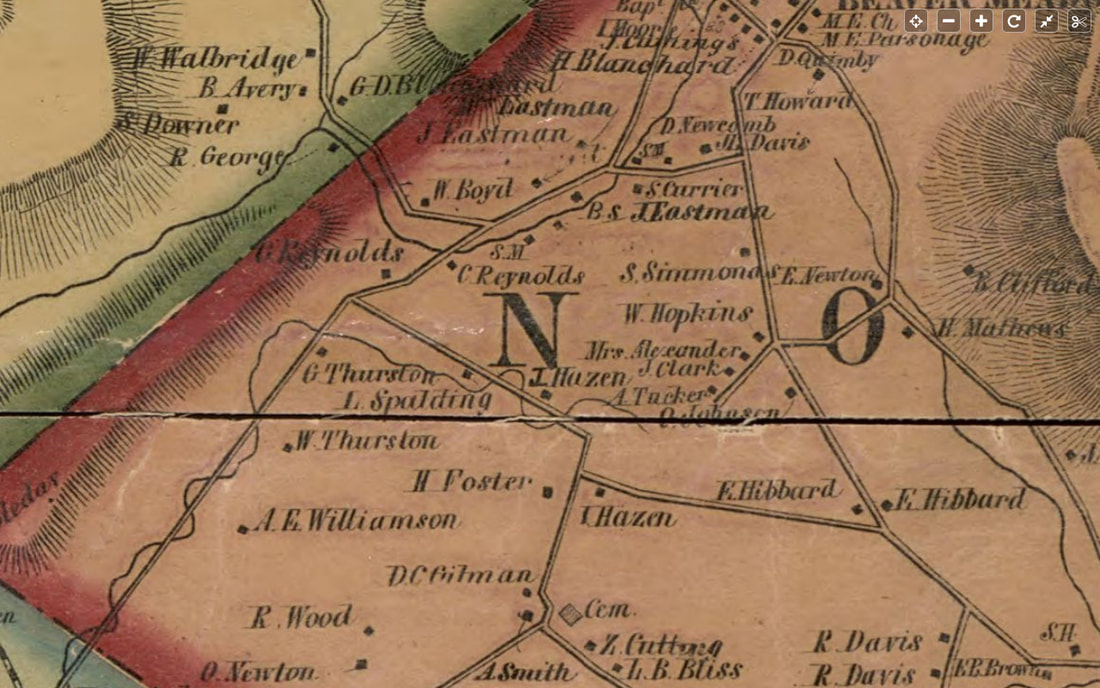 Close-up View, 1855. Parkhurst Cemetery is Center, Bottom. It's an area that is sparsely settled today, but holds clues to former activity in what is today, mostly forest, abandoned roads, and trails. Parkhurst Cemetery is in the center, bottom of the map above. In the map above, from the Parkhurst Cemetery, heading north, we get to a corner with "T. Hazen" on the right, and "H. Foster"on the left. This is most likely the corner of Sue Spaulding Road, and Burton Woods Road. Indeed, we can see that L. Spaulding had a place on Sue Spaulding Road. A right turn at this corner, would bring one back to Bragg Hill, west of Schoolhouse Road, and east of Tucker Hill Road. Bearing left on Sue Spaulding Road leads to Tigertown Road. Sue Spaulding and Burton Woods roads are old roads that have become trails. On the lower right, we see "S.H.", next to "E.B. Brown". That is the Brown Schoolhouse, on Schoolhouse road, which is also a trail. The next map, below is a modern topographic representation from alltrails.com 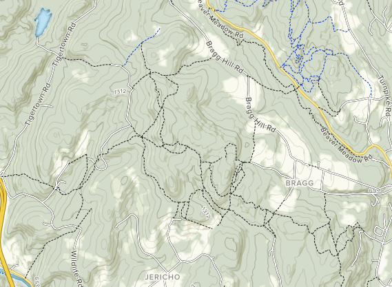 Map of Trails in Western Norwich, courtesy Alltrails.com Above, a modern topographic map of the larger area is shown, with trails indicated by dashed lines. It can be quite confusing, as some paths shown may be logging roads, or former trails. Below is another topographic view, from the 1927 USGS map, showing Tigertown Road, Sue Spaulding Road, Podunk Road, and a portion of Burton Woods Road. In addition, there is a double dashed line leading south from Sue Spaulding Road, that leads to the Podunk School. Perhaps this was a shortcut for the children to take to the Podunk Schoolhouse. It looks a lot steeper than the main route. Maybe the Spaulding children took their sleds in the winter, and went sledding part way to school and back! 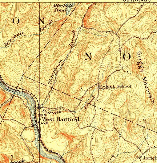 So....Which way to go? It appears there are 4 main ways to hike to the Parkhurst Cemetery. 1. Happy Hill Road to the AT South, to Burton Woods road. 2. Burton Woods Road (From Bragg Hill Road) 3. Sue Spaulding road to Burton Woods Road 4. Podunk Road, W. Hartford > Appalachian Trail > Burton Woods Rd. I've decided to take the third option, Sue Spaulding Road, which, appears to me to be the shortest and most direct route. Below is a google earth image of the route from Bragg Hill to Burton Woods. However, I've learned from experience, that the location of the cemetery may be a bit off from what is shown here. 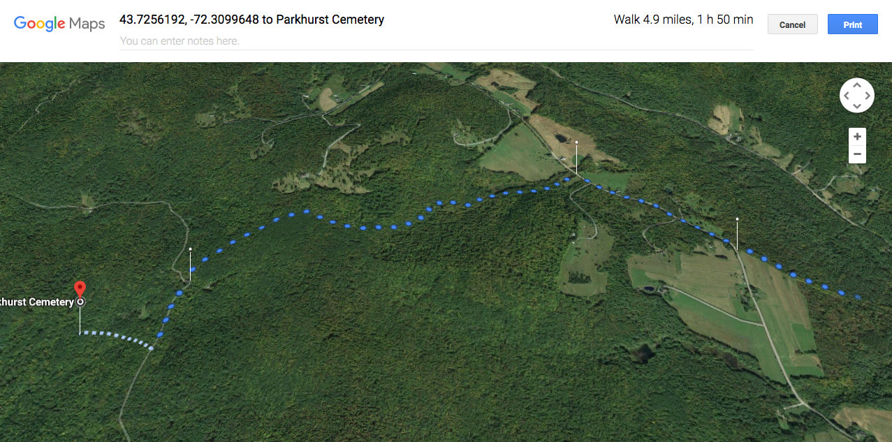 Bragg Hill > Burton Woods > Parkhurst Cemetery, courtesy Google Maps. It appears this is the longest route in, at 4.9 miles to the Parkhurst Cemetery. Below is the route I've decided to try. We'll park at the corner of Sue Spaulding Road, and Tigertown Road, and walk out Sue Spaulding. It looks like there's about a 300-400 foot gain in elevation, heading to the cemetery. Google Earth indicates a 6 minute trip, but I don't think they realize we don't really drive on these roads much anymore! 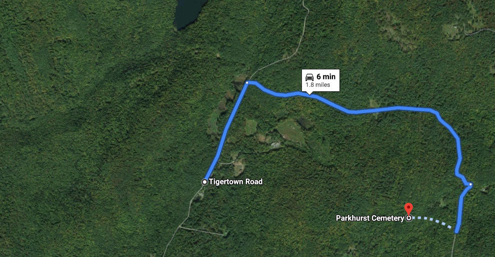 Tigertown > Sue Spaulding > Burton Woods > Parkhurst Cemetery. Photo courtesy Google Maps. As I write this, I'm waiting for a friend to call me about hiking to the Parkhurst Cemtery this afternoon, 1/28/2020. Below is a photo taken of the old graveyard in the woods, back in 2008. I'm hoping to find something similar out there soon, only 12 years later. I'll report back with my findings soon, hopefully! 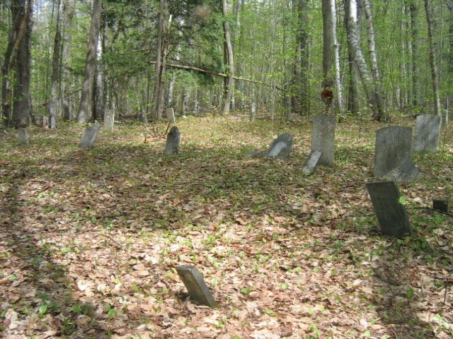 Parkhurst Cemetery in 2008. Photo taken by "AJ", courtesy of findagrave.com Thanks for hiking along Old Roads Rivers and Rails of the Upper Valley
with me, Bob Totz Feel free to check out some of our other adventures exploring old cemteries here: https://oldroadsuppervalley.weebly.com/cemeteries-upper-valley-vt-nh.html ...and our list of local trails here: oldroadsuppervalley.weebly.com/hiking-trails-upper-valley-vt-nh.html If you've not already subscribed, and woul like to join our club, (subscribe), and receive free email notices whenever we publish, please send an email to [email protected] and we'll add you to the group. Likewise, please share these articles with friends, and encourage them to subscribe. Thanks! - Bob Totz for oldroaduppervalley.weebly.com Sources: findagrave: https://www.findagrave.com/cemetery/104179/parkhurst-cemetery 1927 USGS map: ngmdb.usgs.gov/topoview/viewer/# Alltrails.com https://www.alltrails.com/explore/us/vermont/white-river-junction Google Maps: www.google.com/maps/dir/Parkhurst+Cemetery,+White+River+Junction,+VT+05001/Podunk+Rd,+Hartford,+VT+05001/@43.7125941,-72.3911362,1849a,35y,359.15h,45t/data=!3m1!1e3!4m14!4m13!1m5!1m1!1s0x4cb4cedfcda16e29:0xed527cf9907ae4f7!2m2!1d-72.3853606!2d43.7345666!1m5!1m1!1s0x4cb4ceeceb0bf135:0x350c7cff8f2604cd!2m2!1d-72.399434!2d43.720351!3e0
8 Comments
 It was January, 1984, and I needed to find an affordable place to live in the Upper Valley. My new home had to be within reasonable commuting distance of my new job, which was going to be in Lyme NH, on Rt 10. I was 24, just out of college, and was moving to a new area, with a new job. where I didn't know anyone yet, and I needed to find a place to live. I had been working as a book editor, on a temporary basis, in Washington DC, and while waiting to hear from the Defense Department, about a mapping position, I interviewed for a job in New Hampshire doing digital mapping for a lot less money. I guess I'm different than a lot of people, in that I chose to take the lower paying job in New Hampshire. However, I would bet there are others in our area who might have made the same choice. The idea of living in an area with much more open space, fresh air and water, and with the Appalachian Trail and other trails nearby, appealed to me greatly. In a geography classs I'd taken at UConn, I had studied with great interest, the concept of "Quality of Life". Quality of Life took into consideration many attributes of a location, including air and water quaility, crime statistics, employment and amenities availability, transportation networks, and availability of fresh food, and other considerations. I could tell there was some serious quality of life going on here in the Upper Valley! NEW JOB, NEW HOME So, crazy me, I agreed to take the job in New Hampshire. Now I had to find a place to live, on what little money I would be earning. I soon found out my options were quite limited. My new place of employment directed me to the Dartmouth Office of Residential Housing. I drove the '74 Valiant Scamp up from my parents' house in Connecticut, one cold snowy January morning, and parked on West Wheelock street. I found the housing office, got my list of rentals, and started scanning for something that I thought I could afford. It was pretty grim. I couldn't afford much. Fortunately, there was a bedroom in a house with a family available in Plainfield. For $185 a month, including utilities, I also got my own bathroom, and use of the kitchen. I called New England Telephone and was able to only get a party line. A party line was something different to me, like a throwback to the "old days". I'd never lived in the north country before, and had a lot to learn, not just about party lines, but also bout things like 30 degree below zero temperatures, and their effect on an old Plymouth Valiant! It was colder here, and much snowier than where I grew up. Cars didn't start as easily, sitting in the wind and subfreezing temperatures for days on end. 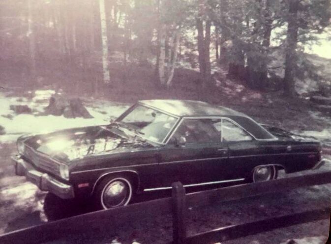 1974 Scamp, My First Car, Shown Here in 1984. My car was ten years old, and it didn't take long for the road salt to take effect either. I'd never owned a car before, and I was fortunate, in that my parents had given me this car to help me get established in my new community. I soon learned and began to do basic car maintenance, like oil changes, and body work, in order to save money. My first spring in the north country was beautiful. A good friend from college drove up and hiked up the fire tower on Smart's Mountain with me. When I saw the view of the Connecticut River valley from the top of Smart's, I knew I had found my new home.... 1988: FOUR YEARS LATER.... AFFORDABLE HOUSING? After a few years of digital mapping, and a few surveying jobs, I found myself working for the US Postal Service. Between 1984 and 1988, I had lived in six different places in the Upper Valley, first in New Hampshire, and then Vermont. It seemed that every time I thought I was getting settled, my landlord decided to sell the house, or have his daughter move in after my lease ran out. I took out a new car loan, for a 1988 VW Fox station wagon, and began looking for some real estate I could purchase. I had always heard, and believed, that real estate was the best investment you can make. Why pay rent, when you can pay a mortgage over 30 years or so, and then have a great investment paid off, that you could sell someday? Plus, once you pay off the mortgage, it's like not having to pay rent anymore, though there are always property taxes, and maintenance costs associated with owning as opposed to renting. It's a personal decision, to rent or to buy, but I definitely wanted a place to call my own someday. When I checked with my local bank, I was disappointed to find out that the only way I was going to buy property was to get my car paid off, which I had just purchased. The monthly car payment affected my ability to pay a mortgage, so I worked overtime and paid extra principal on the car each month, and got it paid off relatively quickly, in about a year and a half, all the while watching the real estate ads and seeing what the market was like. 1988-1989 Once I paid my car off, I found out I could afford a home in the $65,000 dollar range. $65,000 didn't buy much, even back then. I looked at a house in White River Junction, that was within walking distance to my job, but the place needed way more work than I wanted to put into it. I almost bought a small piece of land in Sharon, on which to build. Unfortunately, I soon found out that it was all ledge, and would probably need to be blasted in order to put in a foundation. So much for that one too. Eventually, I put a deposit on a place in Strafford. It was a winterized camp, that came furnished. An old woman had lived in it, and even her antique telephone and kitchen utensils were still inside! One sunny Sunday, before the house closing, my parents visited and we had a picnic lunch on the property. It was very peaceful, with spring birds singing in the background. But then, all of a sudden, there was a real LOUD NOISE! It was as if an industrial saw was fired up, just a few feet away! I soon found out that a neighbor, just to the north, was in fact, just behind the tree line, where I could not see. We had come up from the south, and took a left on the right of way to the camp. If we had gone north a short distance further, we would have seen my neighbor to be, and his collections of fine rusting scrap metal, and large, loud machines. Fortunately, I was able to get my deposit back, and continued searching for my new home. 1990 Eventually, it became clear that what I was looking for was a winterized camp, as that was all I could really afford. I had always loved camping, and roughing it, so the idea had sort of a romantic charm for me 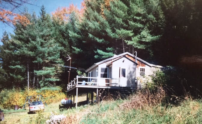 My First Home, in West Fairlee Center. ca 1990. I settled on a small place in West Fairlee Center, with a nice wrap around deck, and a pleasant local view of the neighboring farm, with cows grazing in the fields. It would be about a 40 minute ride to work on a good day, but I loved the peaceful beauty of the place, and I could move right in after the closing and start living there. It would be a nice retreat to return to after a long day's (or night's) work in White River Junction. 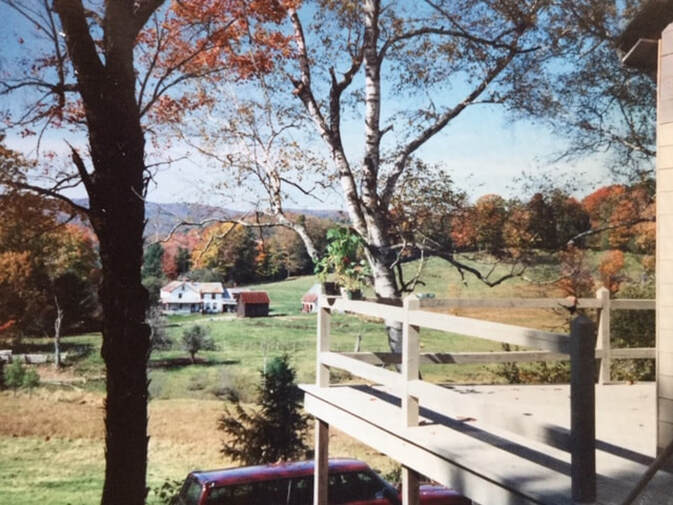 View from the Home in West Fairlee Center. 2020 AFFORDABLE HOUSING IN THE UPPER VALLEY Today I like to pretend I'm 28 again, looking for an affordable place to purchase and live in year-round. I usually look at real estate ads, almost on a weekly basis, just to see what's out there, and I always check the entry level market. What is out there for those new to the market and on a tight budget? Those who can save up a down payment and closing costs, and have the time, energy and desire to work hard and improve something over time, can be rewarded with a home of their own, though it could take months of searching, just to find it. Here is my list of interesting offerings at the low end of the spectrum, under $100,000 as of today, January 25, 2020. Yes, I realize I can be pretty optimistic! The first listing is in Hanover: 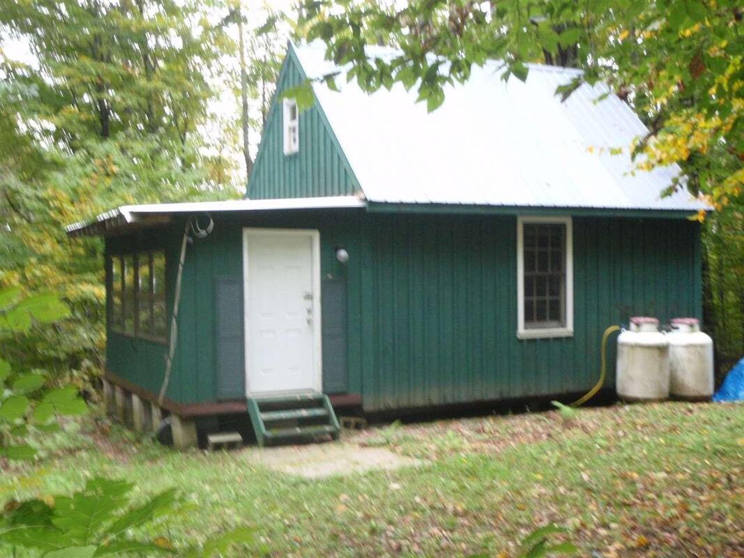 $69,000 Hanover NH, 148 Goss Road on half an acre. This cute cabin is listed as seasonal, and is east of Etna, out near Moose Mountain, but still in Hanover. If I were interested, I would inquire as to whether there were covenants on this property. It could be a cozy, rustic starter home for a single person or couple. It might be possible to live in it in the warm months, while building a winterized addition, or separate home, (and a septic system) It has a lovely wood paneled interior, even though there appears to be no bathroom. It would be worth asking how far away a power pole is, and seeing if there could be a solar site on the property. 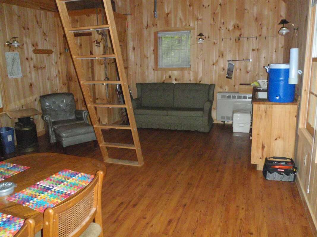 A listing for the above house in Hanover can be found here: www.biggreenrealestate.com/displayprop/Hanover/NH/Home/4721828 The next listing is in Norwich: 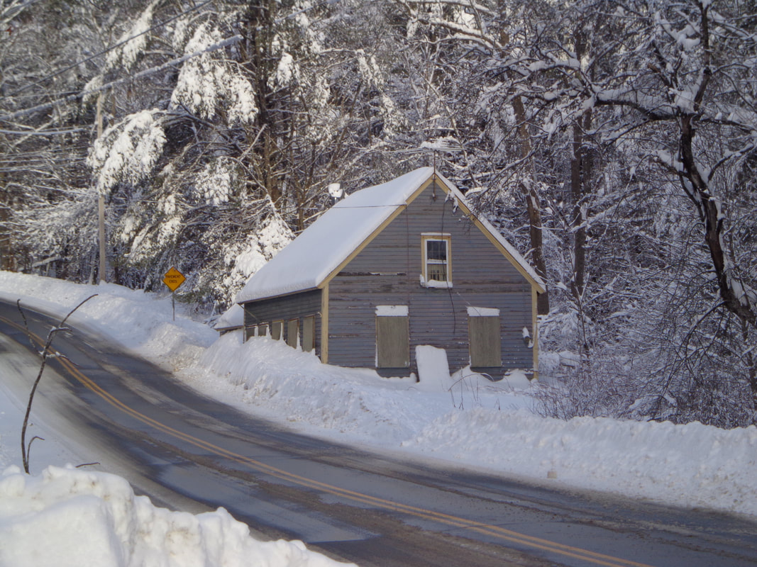 2. $70,000 Norwich VT 1802 Beaver Meadow Road with 4.7 acres near the Sharon Town Line This listing is for almost 5 acres of land, however, there is an old house on the property, and it's literally right on the road, as you can see by the plowed snow against the house. It's possible the road was re-routed at one time. I remember when the owners used to come to this place every July 4th, and open it up, and spend a few weeks or months there every year. The place has been unoccupied for at least 10 years, and considering the appearance, it’s obvious why the house isn't emphasized in the listing. It is located near the Sharon town line, with a wooded, south(ish) facing hill behind the house. It’s a short walk to the Beaver Meadow chapel and schoolhouse. If I was young, and ambitious, I would see value here, and investigate whether the frame of the house is worth saving. IF it’s an old post and beam frame, it might be able to be sold, or re-used/repurposed. Eventually, I would want to clear land above the house, put in a driveway, and build a house up above, where there appears to be nice solar gain. Every time I drive by there, on a sunny afternoon, I look up above the house and see the sun streaming in on the trees on the hill, up in back. This listing can be found here: https://www.coldwellbanker.com/property/1802-Beaver-Meadow-Road-Norwich-VT-05055/M-4777260-NH_NNEREN/detail?src=list The following listing is in Canaan, New Hampshire: 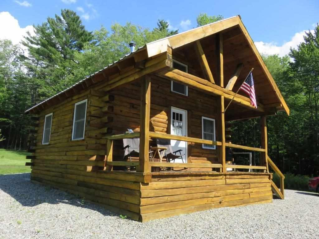 3. $69,000 Canaan NH 115 Sugar Hill Road. Off-grid camp on 2 acres This cute little camp boasts a generator, an insulated ceiling, and a toilet. It sits on concrete posts, and has a southwest view from the front porch. 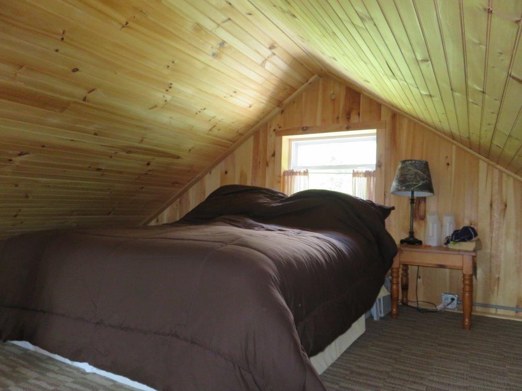 There is a sleeping loft on one side, and a cathedral ceiling on the other. This camp was built in 2011, and seems like it might be worth a look. It's off of Grist Mill road, south and west of US 4. The listing can be found here: www.biggreenrealestate.com/displayprop/Canaan/NH/Home/4772978 The next place is in Strafford VT: 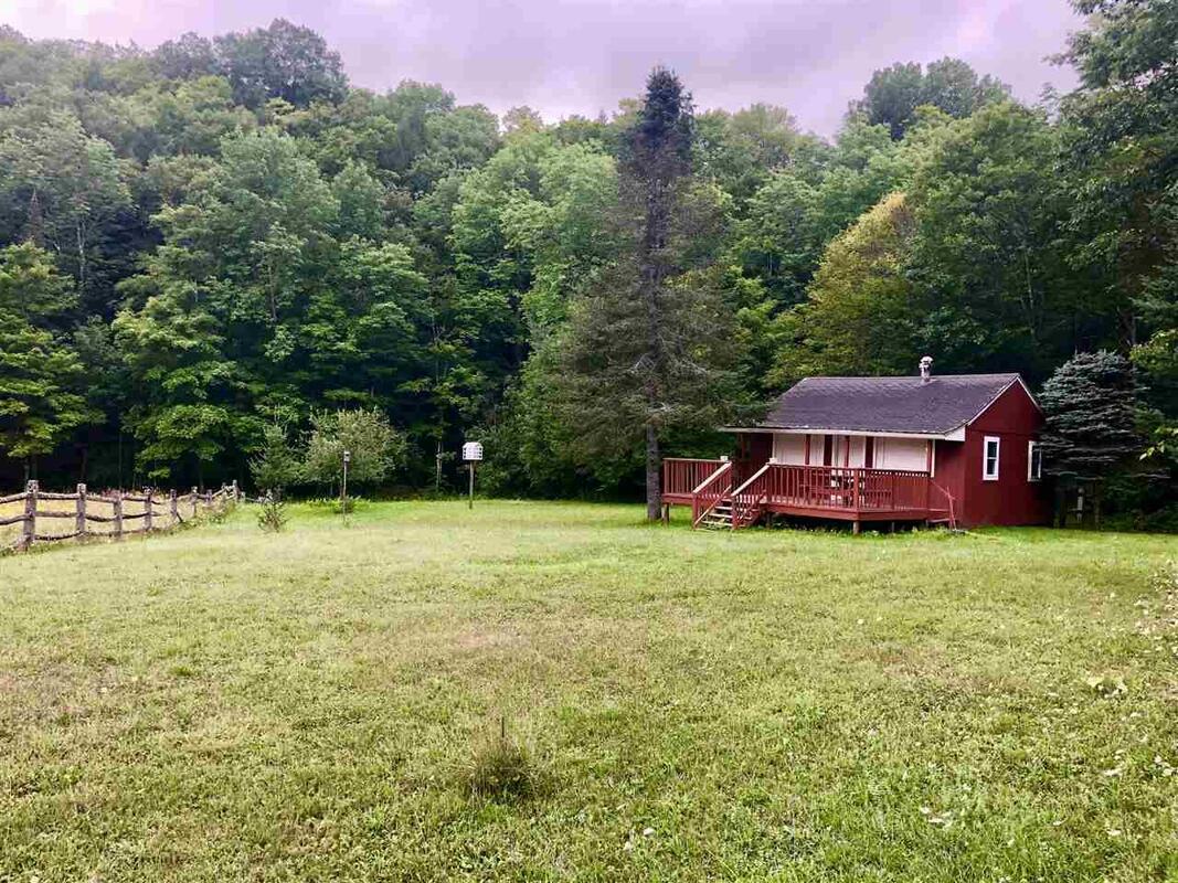 4. $89,000 Strafford VT, Camp on Miller Pond Rd, on 3.9 Acres I’ve been admiring this camp for years, and it is currently on the market for $89,000. This cute camp sits on piers, has gas lighting and a hand pump for well water. 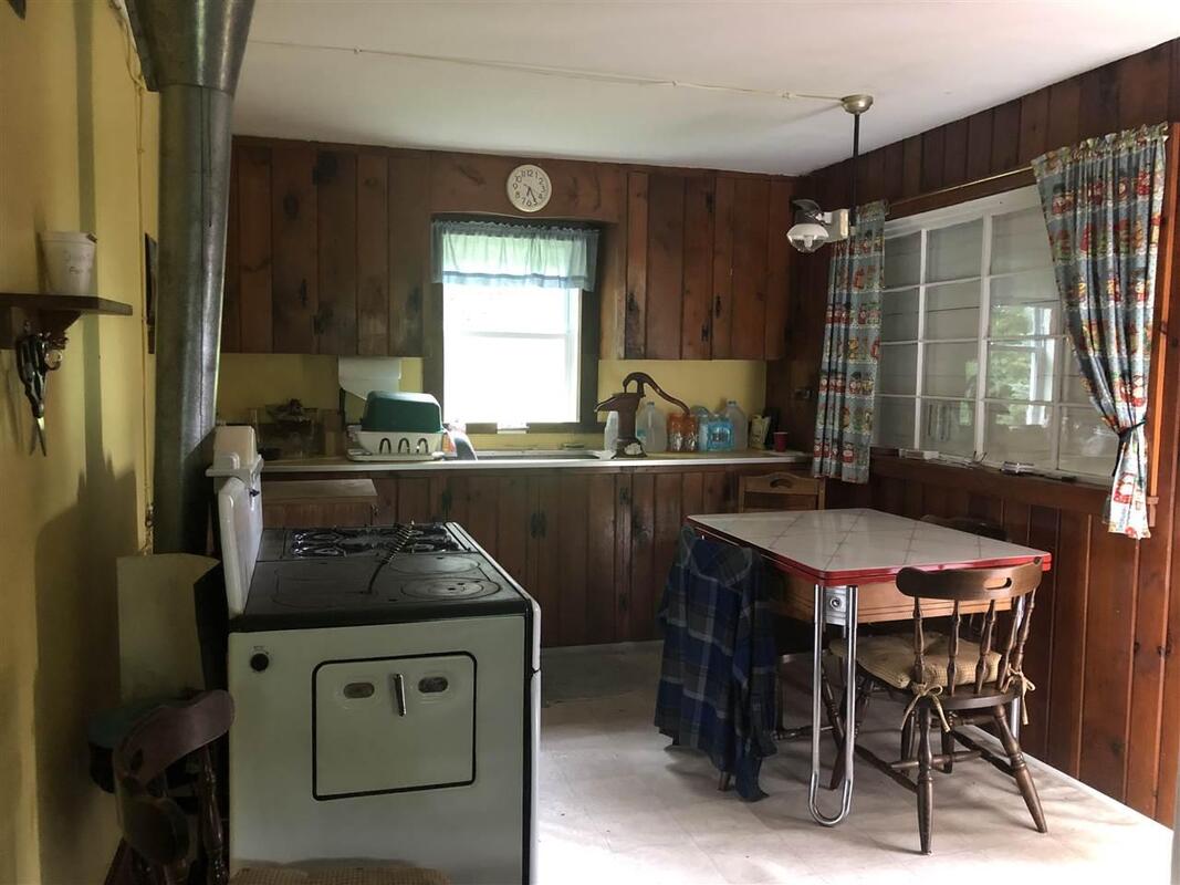 This cabin is currently off-grid, but is close enough to the road, that it shouldn’t be a problem to hook up to the electrical grid, if that’s what you want. It might be a good solar site as well. 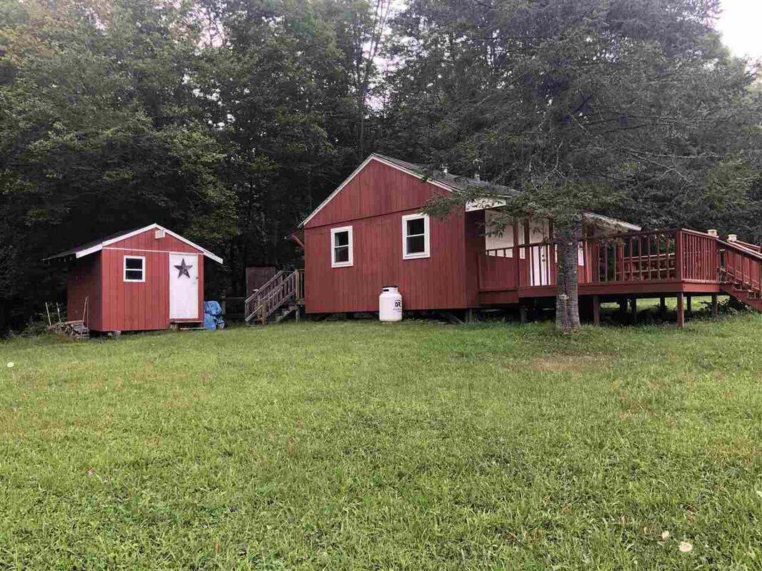 There’s 3.9 acres, a nicely cleared yard, a babbling brook…and room for a pony! There's more information and phots here: https://www.coldwellbanker.com/property/61-Miller-Pond-Road-Strafford-VT-05070/M-4770016-NH_NNEREN/detail?src=map&hdMlsNumber=4770016&hdMlsSource=NH_NNEREN The last offering is in Sharon Vermont: 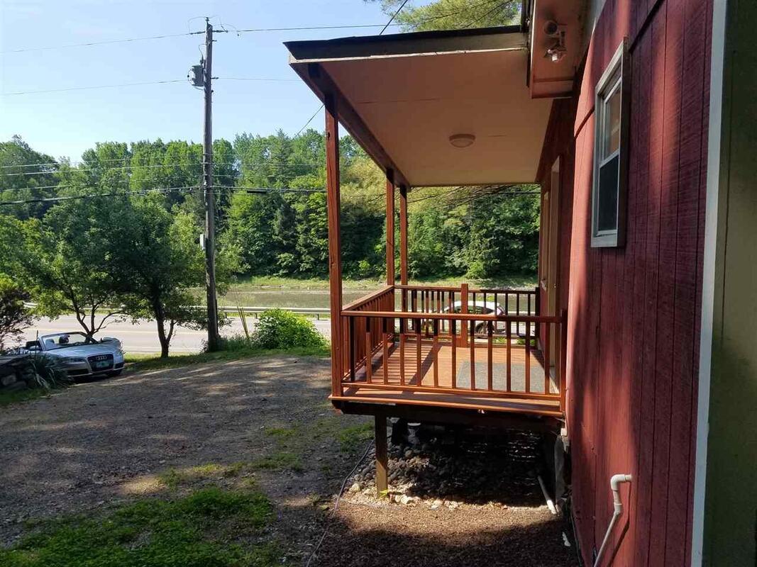 5. 80,000 Sharon Vermont on 1.8 Acres This is a great location, if you like being near the White River, and don't mind being on Rt 14. It’s just a small place, with a couple of porches, close to the road, and it sits on a 1.8 acre lot. I think it was once used as a rental for students from the VT Law School. It could be a starter home for someone, and it’s conveniently located not far from exit 2, I-89. It just seems like it has a lot going for it, considering the price, lot size, location and accessibility. For the money, this one is the one I would choose from the five places listed here. Here is further information on this one: https://www.coldwellbanker.com/property/6336-Route-14-Route-Sharon-VT-05065/M-4761260-NH_NNEREN/detail?src=map&hdMlsNumber=4761260&hdMlsSource=NH_NNEREN *********************************** I like to think of the early pioneers of the Upper Valley, who came here from Connecticut and Massachusetts in the 1760's. Imagine if they could see what we term today as "roughing it"! I bet they'd get a good belly laugh! They'd marvel at propane powered stoves, heaters, and refrigerators. What would they think about solar panels, electricity, and the things they power? When I think of these things, I realize how much has changed, in so little time. Back in 1996, my wife and I sold the little place in West Fairlee Center, and bought our our current home, another small, former camp. 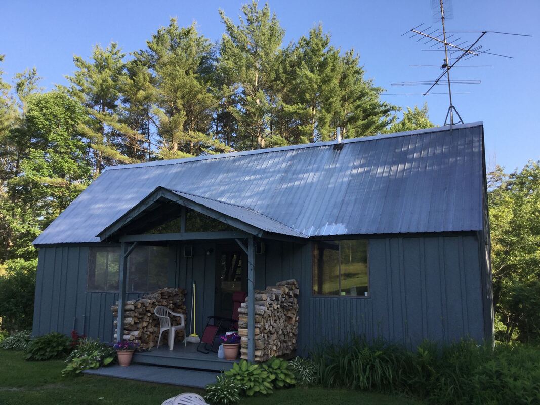 Our home, a former camp. Photo is from a few years ago, after replacing the front porch, but before we put on a new standing seam roof. Thanks for rambling on down Old Roads Rivers and Rails of the Upper Valley, with me, Bob Totz.
Thanks also to coldwellbanker.com and biggreenrealestate.com for listing links, photos, and information. 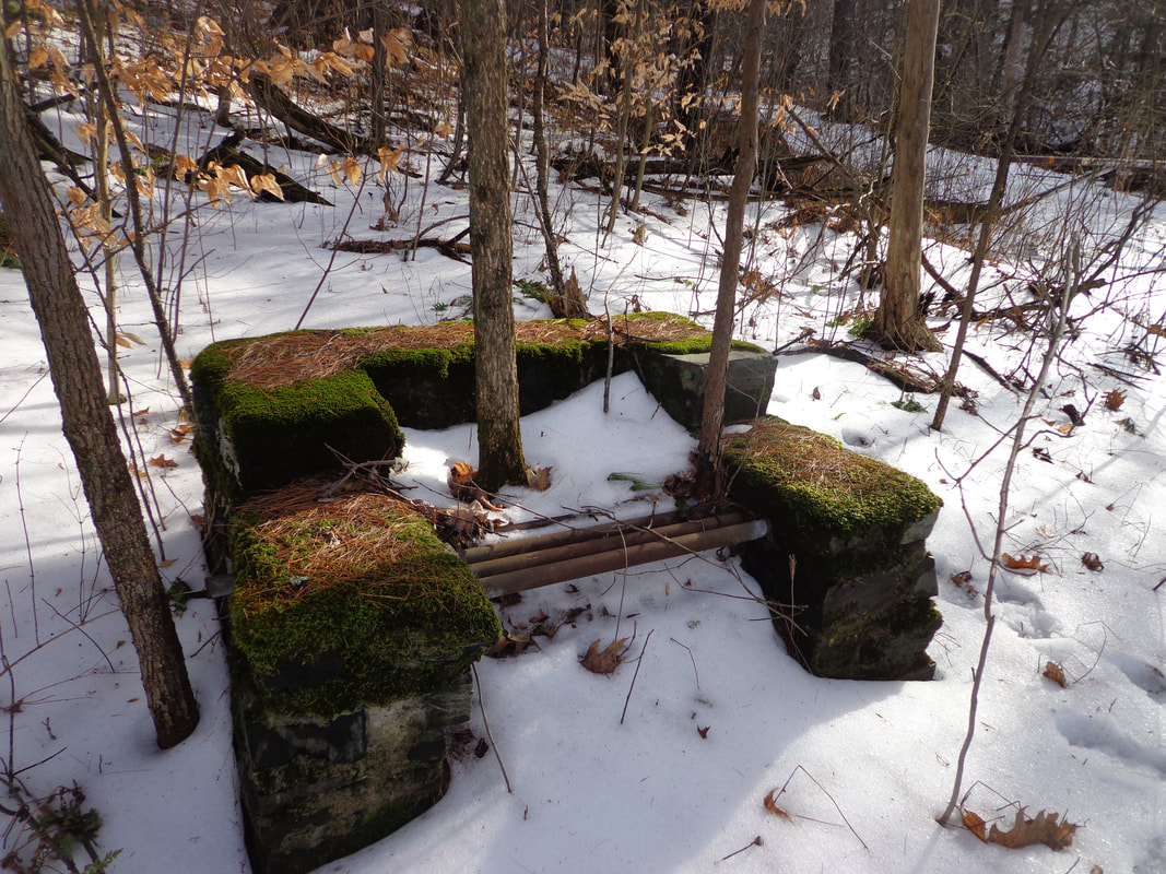 The old stone grill was found in the woods. The old stone grill was covered in moss. The old stone grill tells tales of the past. A tale of a place that has changed. There was something here once, That is gone now. The sunlight played off the moss, As I pondered the past. Families gathered around. Smoke wafting, Food cooking, Laughter, Smiles. Games. Fun. There are two trees now growing through the old stone grill. Do you know where this is? Many may know, but I almost missed it! Clue: It's within view of the Connecticut River, in a public place, near a trail. 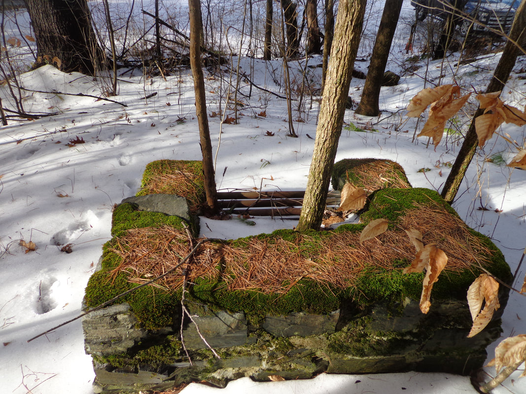 The Old Stone Grill Rests Silently in the Woods Thanks for checking out Old Roads, Rivers and Rails of the Upper Valley
We're looking to increase our subscriber base. We currently have 157 subscribers. If you'd like to receive and email notice whenever we publish a post, please send an email to [email protected] - Bob Totz 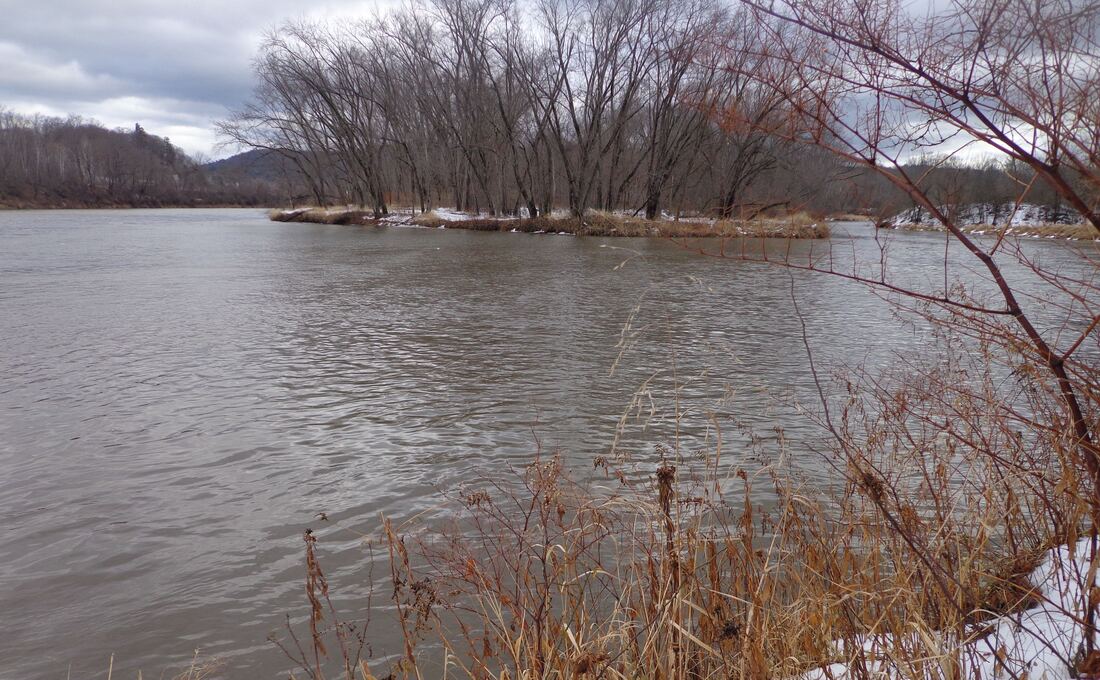 Confluence of the Mascoma River, on right, and the Connecticut River, on left at the Two Rivers Trail. A hiking trail is the last thing I expected to find behind K-Mart, but not far from the exit 20 northbound on-ramp, lies the Two Rivers Trail, that leads to the confluence of the Mascoma and the Connecticut River. It's a beautiful spot, really. I found out about it the other day, when I was doing some research for the new "Hiking Trails" section of this website. 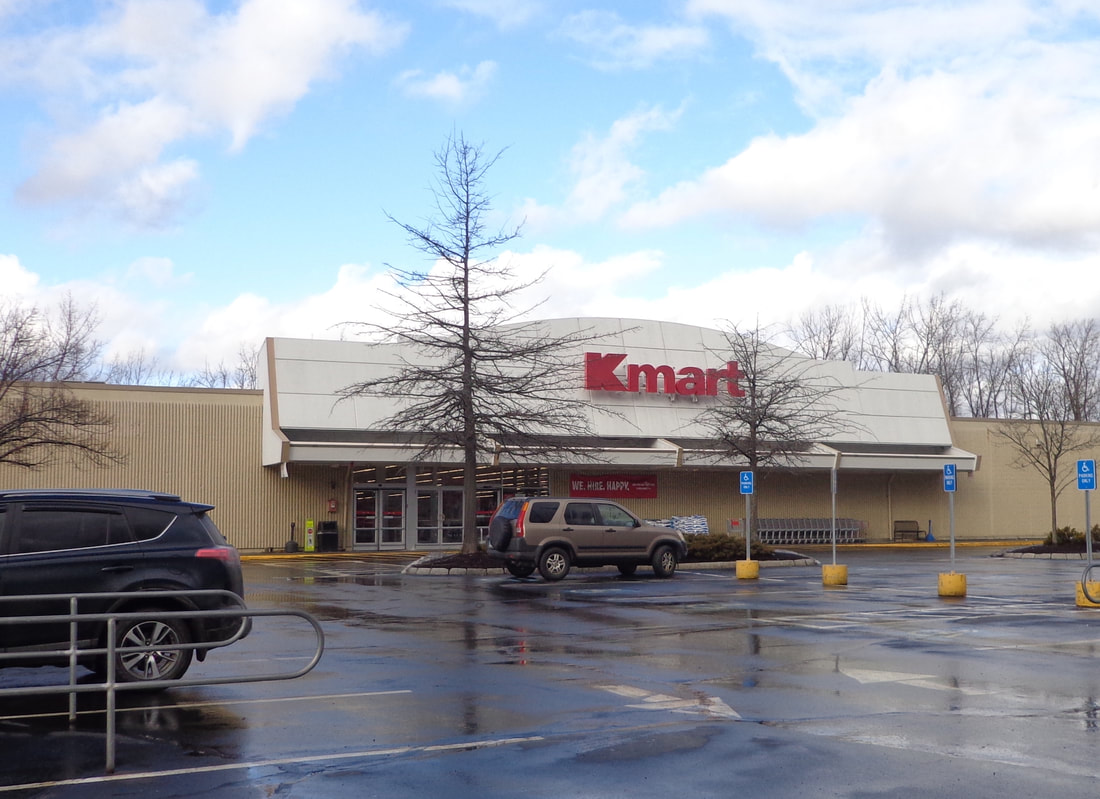 Kmart, and the Kmart Plaza, Route 12A, West Lebanon, New Hampshire On Sunday morning, January 12, 2020, around 10:00 AM, my wife and I decided to head out to West Lebanon to check out Two Rivers trail. The rain had stopped earlier in the morning, and although the sun had been out, it started to cloud up again, with a balmy breeze. As we left home, the temperature was 47 degrees, but when we pulled around to the left side of the Kmart building, the temperature had risen up to 58, not bad for a mid-January day! And probably a rare opportunity to hike around back there without skis or snowshoes. 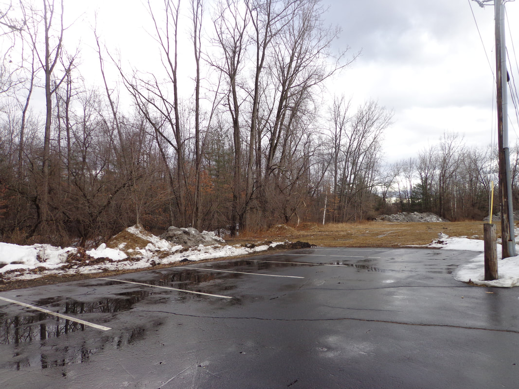 Parking lot to the left of, and to the rear of, Kmart. We walked across the lot behind K-Mart, not really seeing any sign of a trail at first. The ground behind the rear access lot was very wet, with some snow left on it. There was a huge pile of snow and rocks or debris at the end of the lot. As we got closer, I could see a couple concrete blocks, and then I sighted a kiosk not far from the edge of the woods. 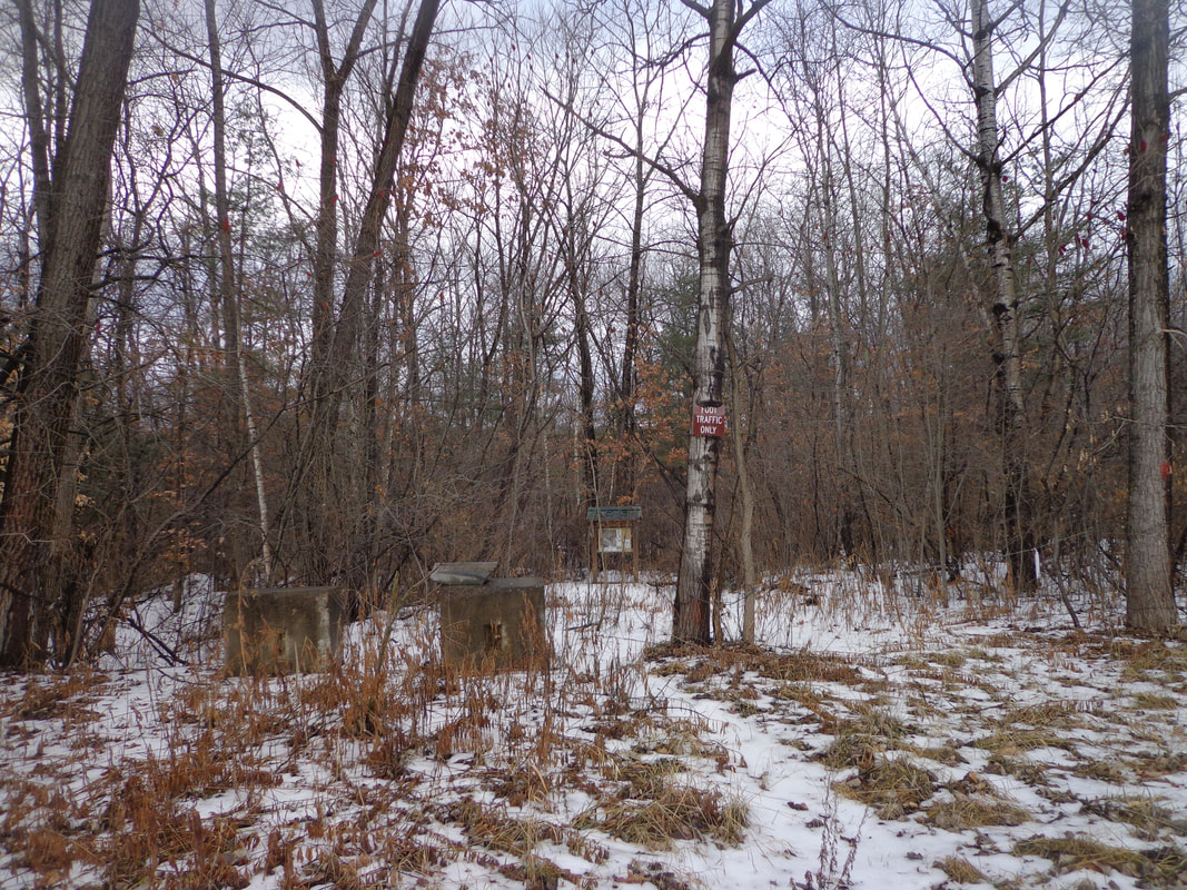 Concrete Blocks, a narrow Footpath, and a kiosk in the Distance The kiosk had a photo / map of the trail, and a nice bird’s nest on top, under the roof! 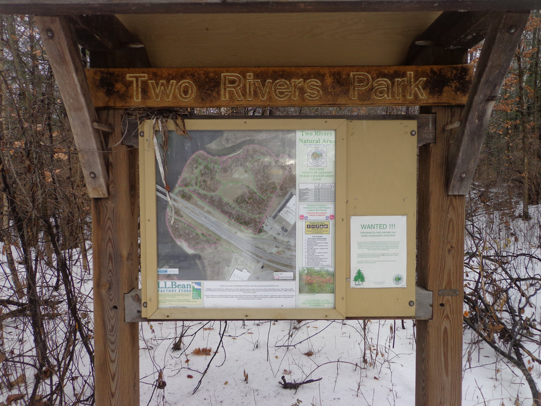 Two River Park Kiosk 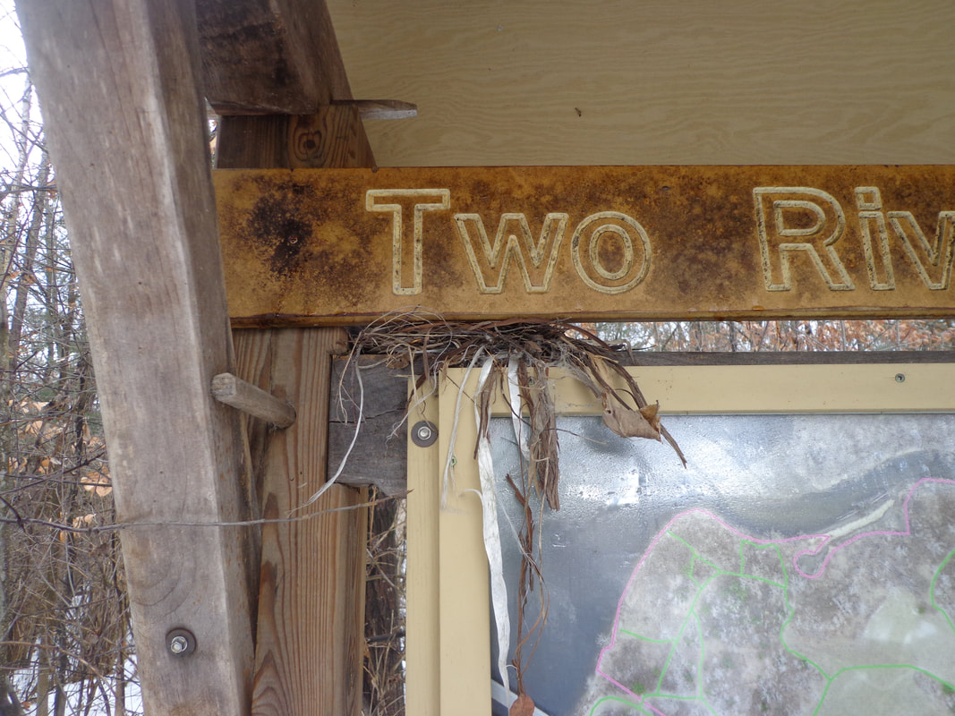 Bird's Nest on the Kiosk It appeared there were no blazes indicating the way, but it was clear where there was a trail, although it looked like no one had walked it since the last snowfall. 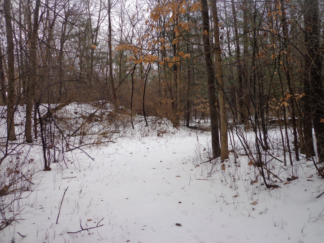 Two Rivers Trail 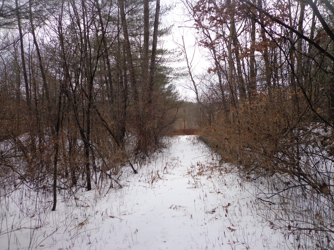 At first it was wooded, but soon we were walking through a more open zone. Wiith the temperature so high, I was hoping no ticks would be waking up! The trail was hard to find at times, but we seemed to find a path. According to the map at the kiosk, there were several trails to choose from. 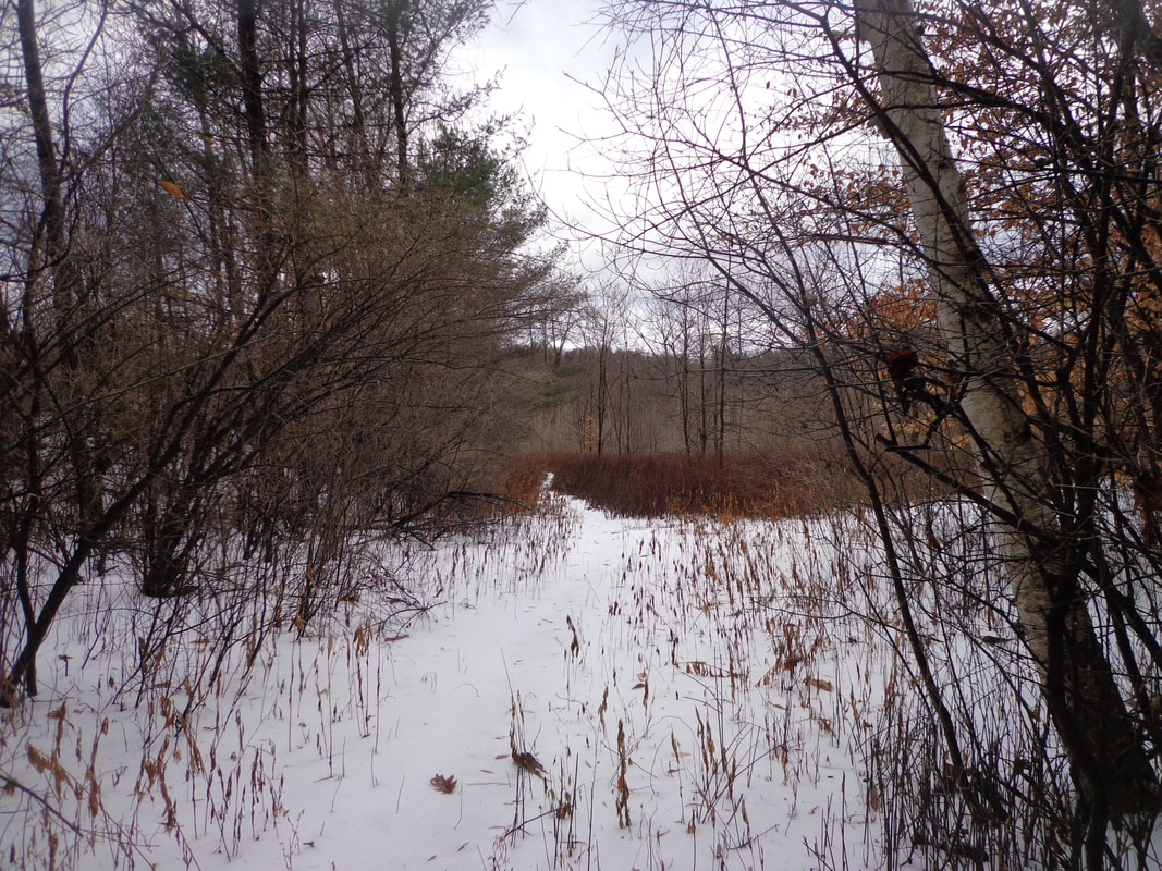 There was a knoll to our right, that we walked around, with a large tree on top. I wondered if there was any historical significance to the knoll. What looked like a pile of stones peeking out from the top seemed somewhat suspicious. 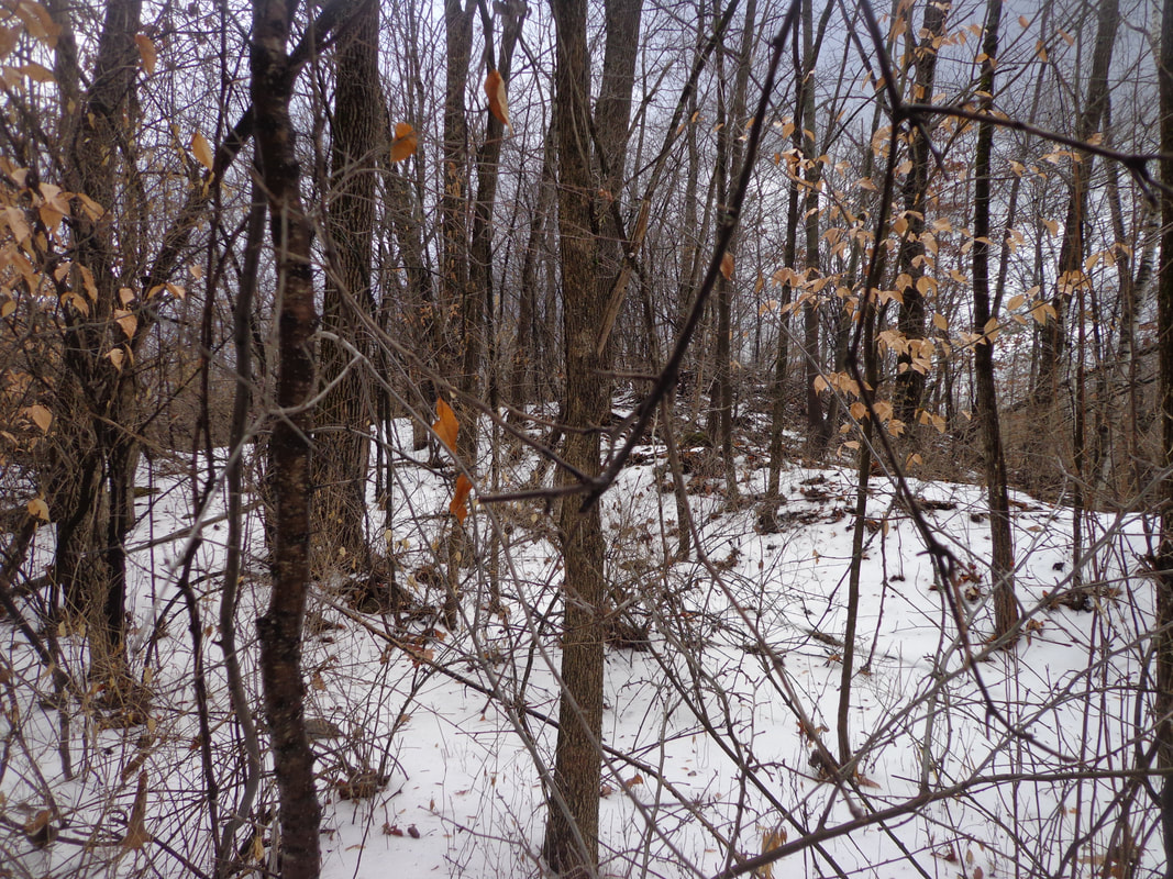 The path meandered a bit and eventually I could see one of the rivers in the distance, through the trees. There were brambles, and thorny weeds in the way, even though it was clear that the weeds had been cut back at one point, not too long ago. 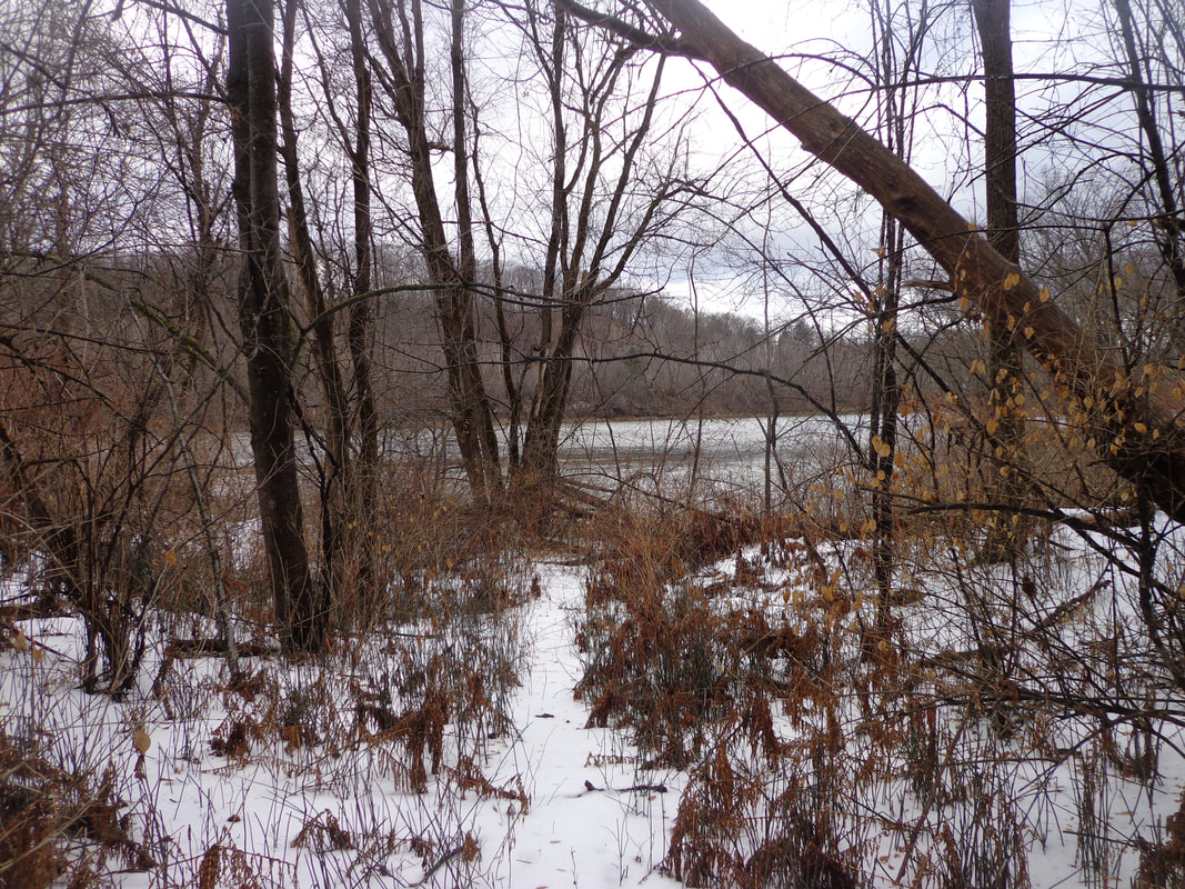 View of the Connecticut River from Two Rivers Trail. We emerged from the brambles at the point where the Mascoma River, on the right, could be seen flowing into the Connecticut River, on our left.  Confluence of the Mascoma and Connecticut Rivers The rivers were flowing strongly, as there was a flood watch in effect at the time. Fortunately, we didn’t get as much rain as had been predicted, but the warm temperature did quite a number on any snow cover in the lowlands.  The Mighty Connecticut River Even with the cloud cover, it was a beautiful spot, and with the warm temperatures, it felt a little bit like a dream, being January. 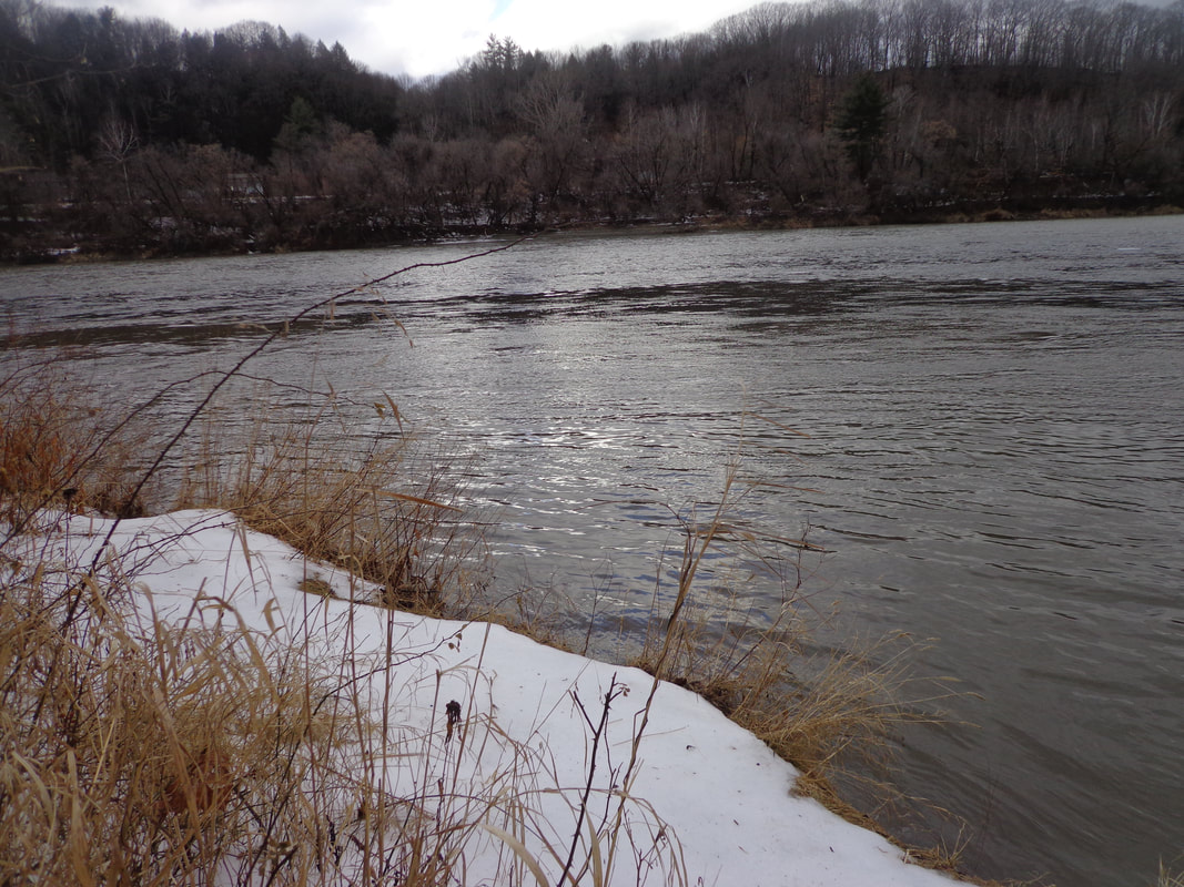 Waters of the Mascoma River Flowing into the Connecticut As we headed back, I took a quick side trip up the little knoll, to look for any clues to the past. All I found was what looked like an old railroad tie, or fencepost, and some cable that looked like part of an old-style guardrail. 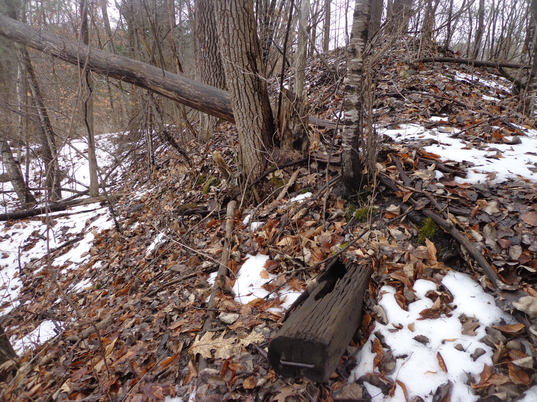 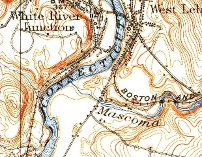 1942 USGS Imagery, Mascoma River flowing into Connecticut River, in the Pre-plaza Era Above is a 1942 image of the area showing where the Two Rivers Trail is now. I believe this was farmland back then. Here is a look at the same area in 1959. Not much going on here in 1959, but just upriver along the Mascoma, we see a power plant. 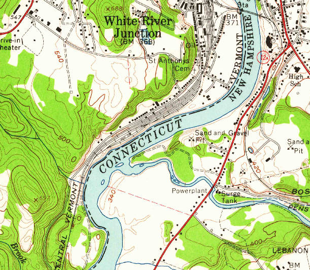 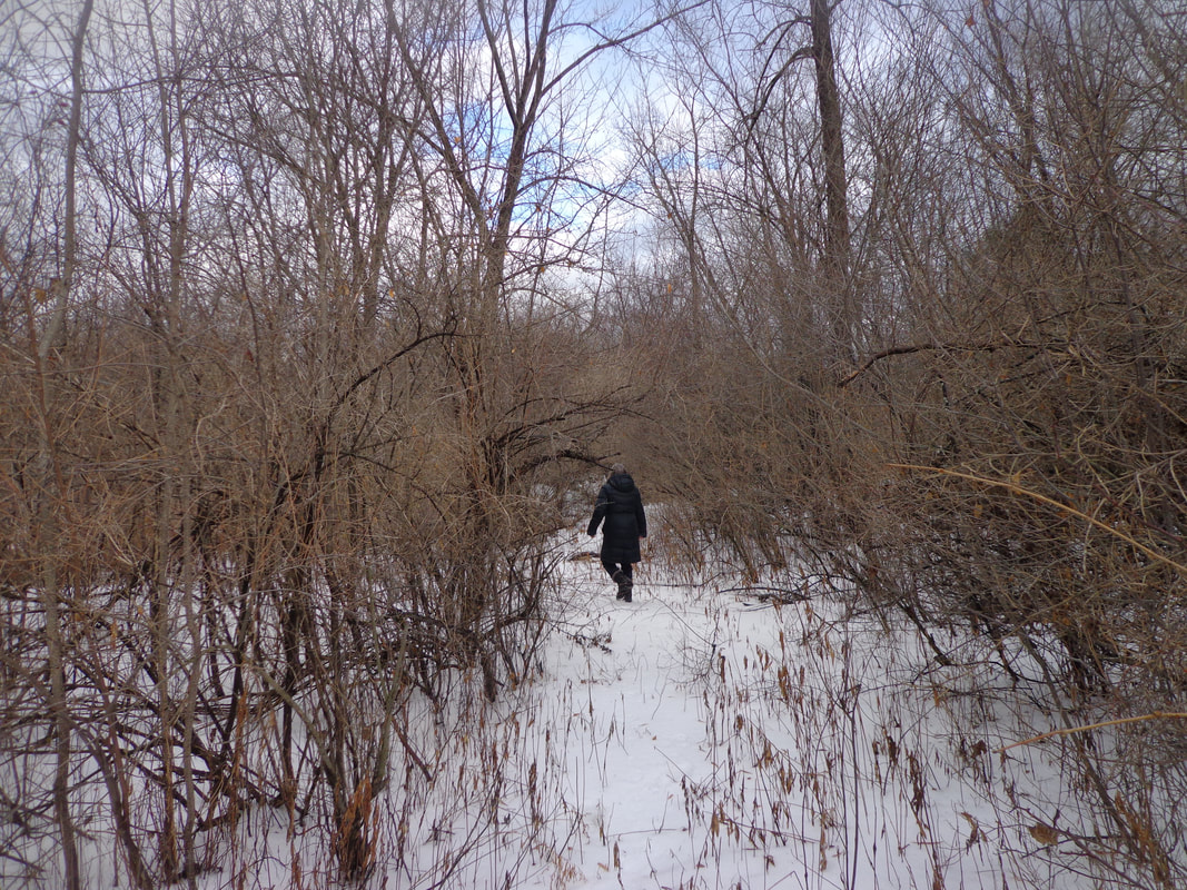 We took a left at a fork, and took a slightly different trail back to Kmart. There were plenty of wild vines and honeysuckles along the way. As we neared the back of K-Mart again, we ended up right behind that huge snow pile, which seemed to be right in our way! 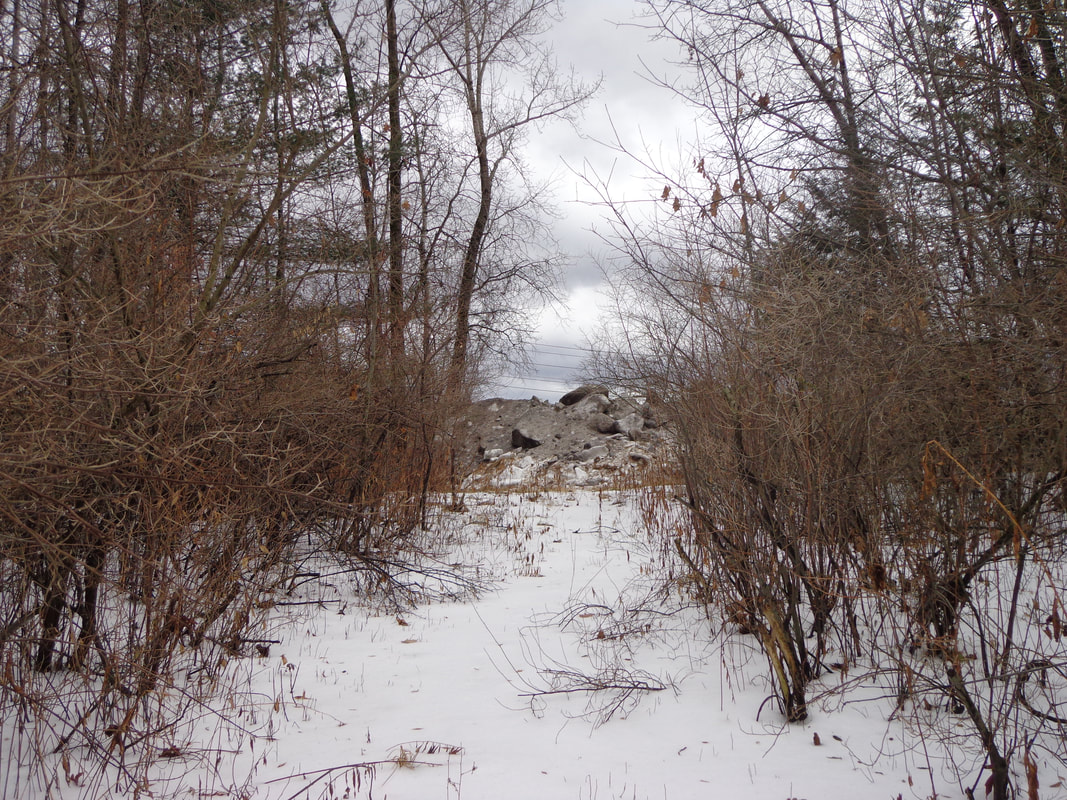 We figured we could either go over it, to the left of it, or to the right, but neither direction looked like the trail. 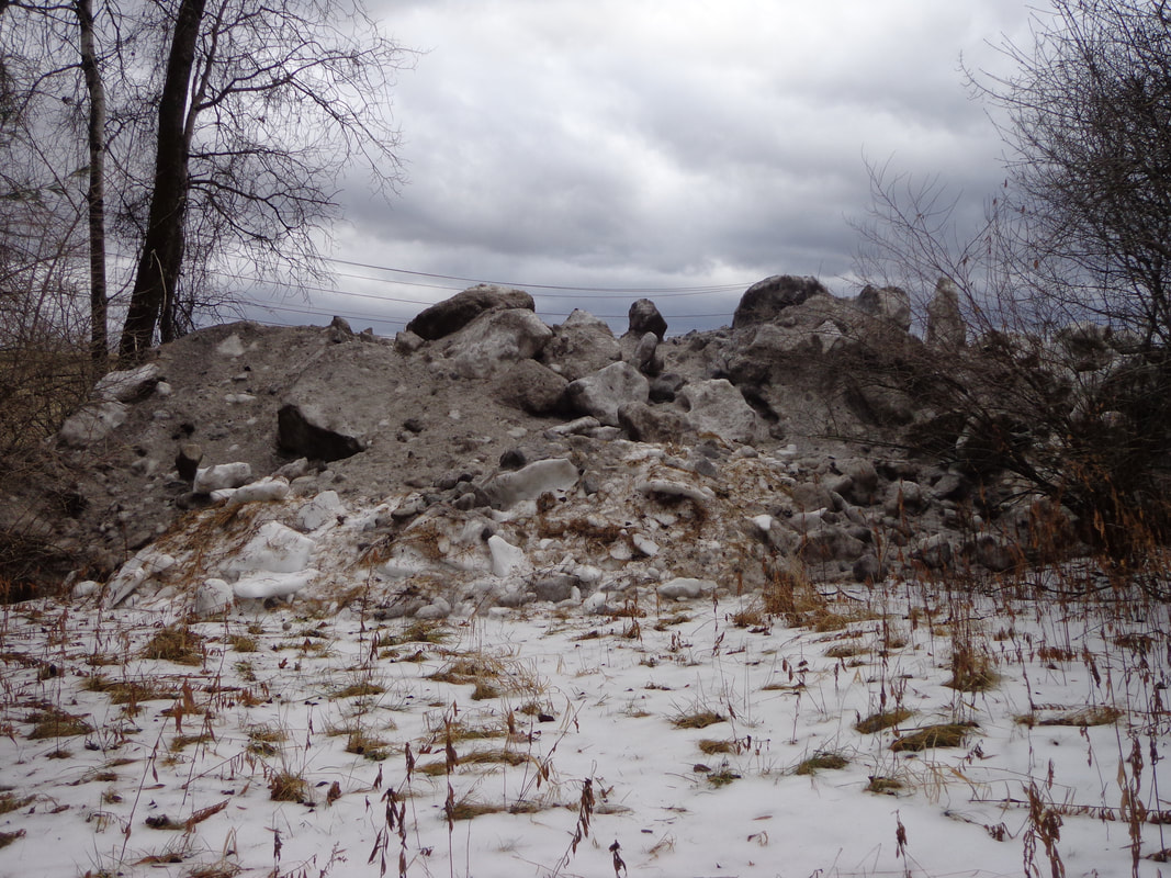 Trail is....where? 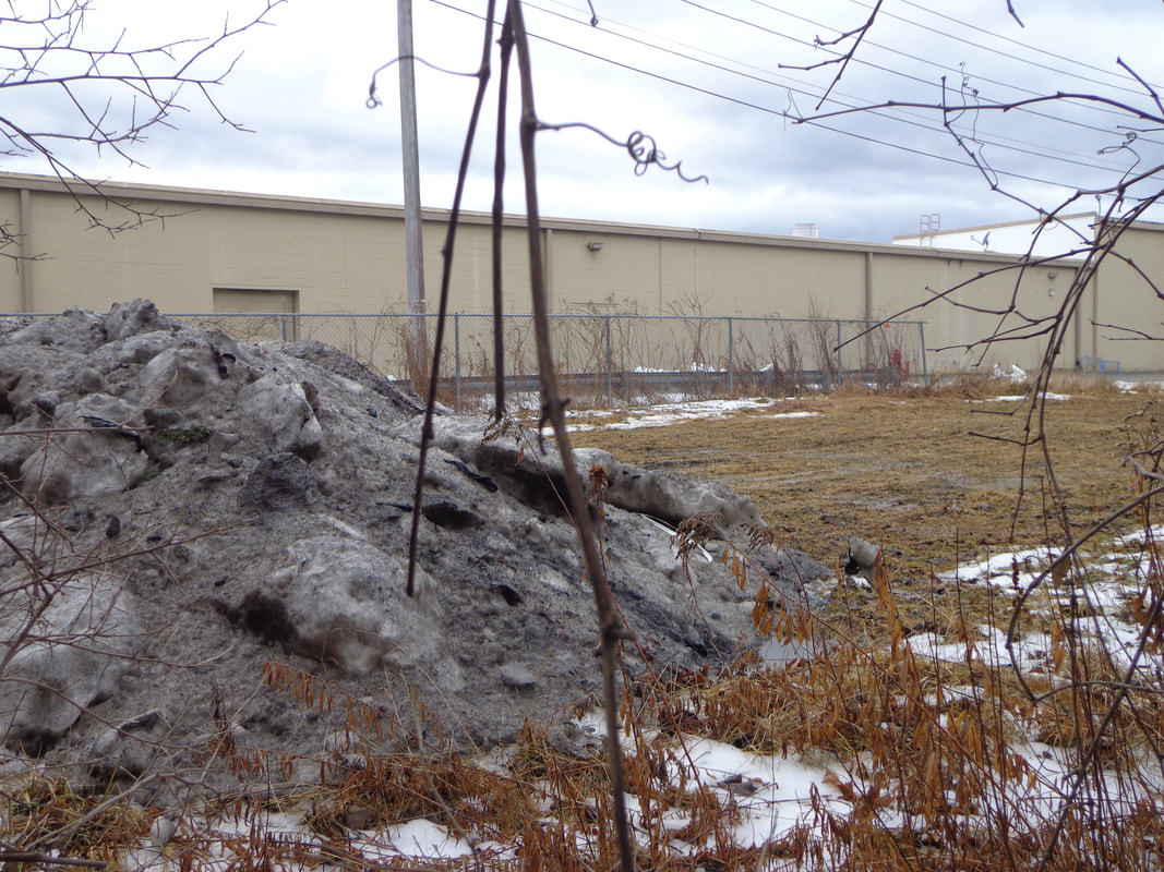 We bushwacked a short distance and were soon in back of Kmart. All in all, we felt quite lucky to have taken the hike out there on a January morning, when it wasn’t cold, and there wasn’t much snow. And, it was quite thrilling to be so close to the Mascoma River, and the Connecticut, wild and free, away from the constraints of the Wilder Dam, after some rain and a bunch of melting snow cranked them up. Finally, it was certainly different to be so close to I-89, K-Mart, and Route 12A, yet to be on a hiking trail. It certainly looks like a very nice place to visit on a warm sunny day! 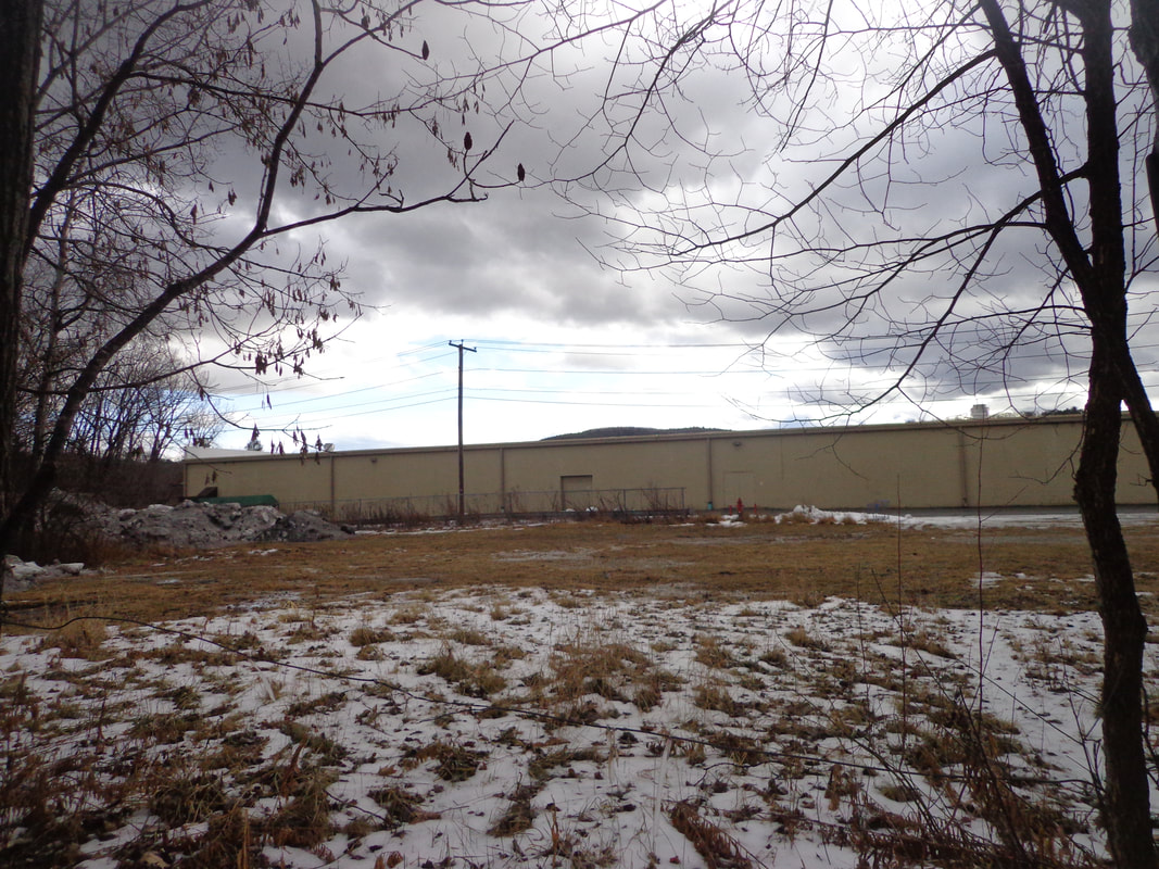 Two Rivers Trail HIdes, Silently, Behind Kmart 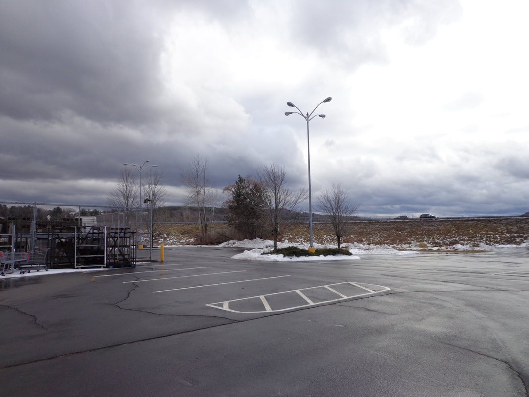 Interstate 89 Northbound On-ramp in the Distance Thanks once again, for hiking along on Old Roads, Rivers and Rails. To subscribe, simply send an email to: [email protected] See you out there on the trail! Sources: https://lebanonnh.gov/Facilities/Facility/Details/Two-Rivers-Conservation-Area-32 US Geological Survey "Topoview" The following map is the USGS imagery from 1981. It shows the Kmart building, and the I-89 interchange, more familiar to us today. 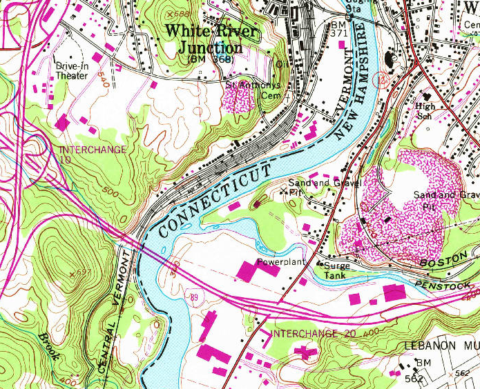 1981 USGS Imagery Below is a current photo; courtesy of google earth 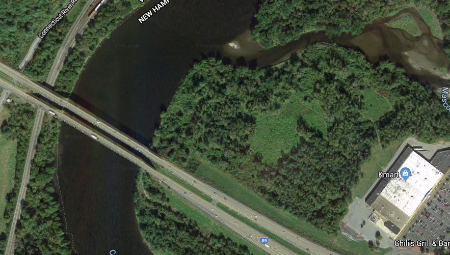 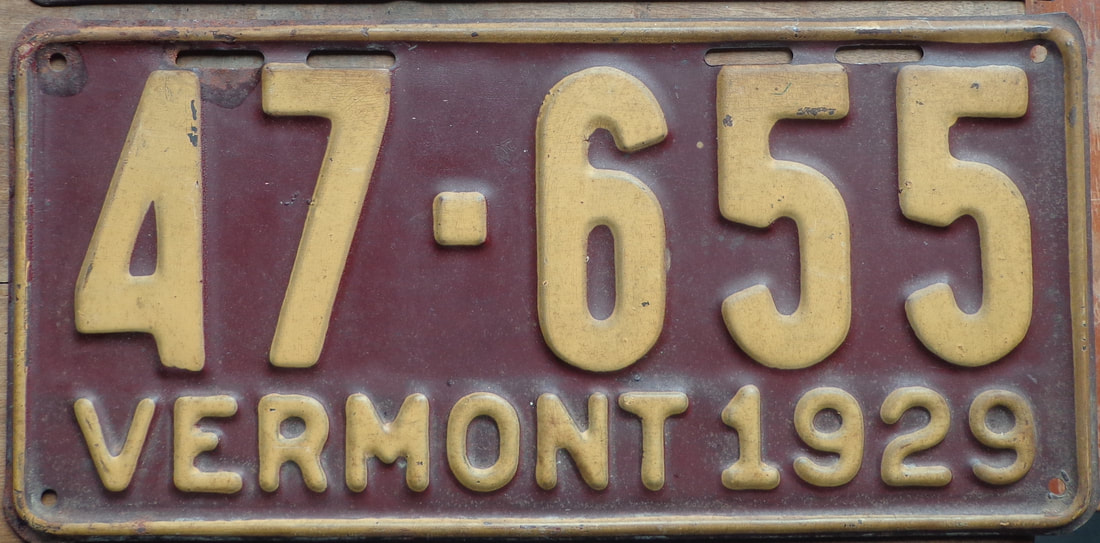 The Colorful Early Automotive History of Vermont The history of Vermont's early motoring is quite colorful, though I suppose most folks haven't really pondered the subject much. Today, you get a license plate, put it on your car, and forget about it, except once a year when you put a new sticker on it. And, of course, you’re required to get your vehicle to pass inspection annually, in case you’d like to use it on public roads. Passing vehicle inspections today is not as easy as it used to be, say thirty years ago. But way back, around 120 years ago, none of that mattered at all. In 1894 Vermont passed its first law regarding automobiles, even though no one in Vermont actually owned one at the time. Among the provisions of the new law was a requirement that a person could not use their car, "...unless he sends, at least one-eighth of a mile in advance... a person of mature age to notify and warn all persons...using the street or highway with horses or other domestic animals..." The first automobile in Vermont was a Stanley Steamer, purchased in 1896 by Dr. Lindsley, of Burlington. The Stanley Steamer ran on steam power like a locomotive. It must have been something to see the Doctor sending a “person of mature age” ahead to warn people in the street that he was on his way in his Steamer. I wonder if Doctor Lindsley felt a special feeling of freedom, not needing a license or a registration, in those early years. 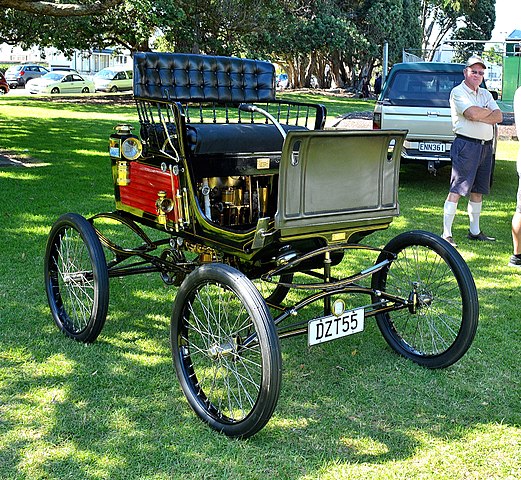 Photo of 1899 Stanley Steamer courtesy GPS, New Zealand via wikimedia commons Like Dr. Lindsley, Jay Leno, the comedian and collector of motor vehicles, also bought a Stanley Steamer. The Stanley Steamer basically used a hot water heater to run the car. They lit a pilot light with a match, and matches were also used to light the headlights. Everything on the vehicle was mechanical. There was nothing electric on the car. You can see a great video of Jay Leno’s Stanley Steamer and laugh as he and his friend take it out for a spin in modern day Los Angeles. The vehicle came with no transmission, and no brakes! It’s worth watching, and fun to hear the horn on the steamer, which sounds just like a steam train. It was pretty interesting technology, I highly recommend the ten minute video with Jay Leno, which can be seen here: https://www.youtube.com/watch?v=hgH88xrYdE4 In the first years of automobile use, there was sort of an adversarial relationship between motorists and everyone else. The early owners of the newfangled curiosities were generally the rich, and they or their chauffeurs drove them mostly for sport and public show. Pedestrians and those with horses and animals soon were upset with the speed and recklessness with which the motor vehicles were being driven, and the danger they represented. In "The Manifold Hazards of Early Motoring", The Cartalk blog had this to say about motor vehicle traffic in 1901: "Although there was almost 40 carmakers in 1901, there were no highway signs, streetlights, traffic lights or indeed any form of licensing. Chaos reigned on the roads. And it got worse as auto populations quickly increased..." In 1903 another Vermont doctor, Horatio Nelson Jackson was interested in using the motor vehicle for long distance driving. While in San Francisco, Horatio made a bet that he could drive a motor car across the country, to New York City. He bought a slightly used 20 horsepower 1903 Winton, and hired Sewall Crocker, an ace mechanic to accompany him. 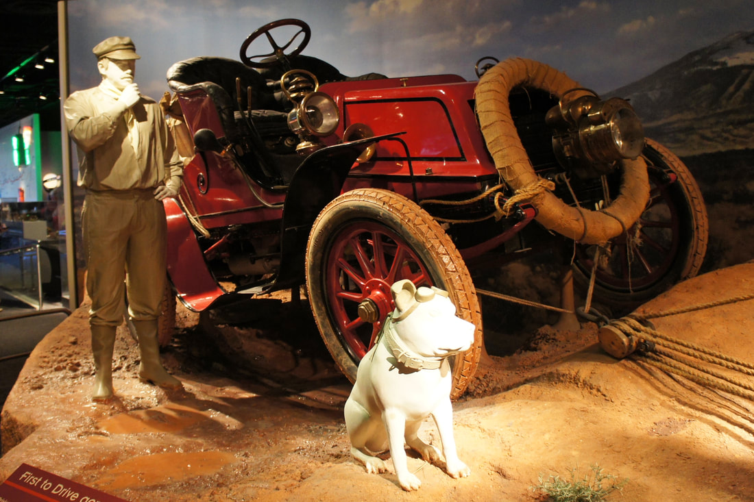 Dr. Jackson, his 1903 Winton, "The Vermont" and his bulldog, "Bud" photo courtesy Mariordo https://commons.wikimedia.org/wiki/File:1903_Winton_touring_car_01_2012_DC_00466.jpg Dr. Jackson and Mr. Crocker left San Francisco on May 23, 1903 and headed toward New York City, where adventure and fame awaited, on the first ever, cross-country roadtrip across the United States. An earlier attempt to cross the country by Alexander Winton, had failed, when he tried to cross via the southern route, through the desert. So Horatio Nelson Jackson decided to take a northern route and avoid the desert altogether. There is a map provided by PBS, where you can click on points of interest along the way, and learn more. The route they took brought them through such states as Washington, Idaho, Wyoming, Nebraske, Iowa, Illinois, Indiana, and Michigan. The interactive PBS map of Horatio's route can be found here: https://www.pbs.org/kenburns/horatios-drive/the-map/ Along the trip east, Dr. Jackson acquired a pet bulldog named “Bud” who endeared many to Dr. Jackson and his quest to cross the USA. Bud wore doggy goggles, and was quite a sight in the newfangled “motor carriage”. 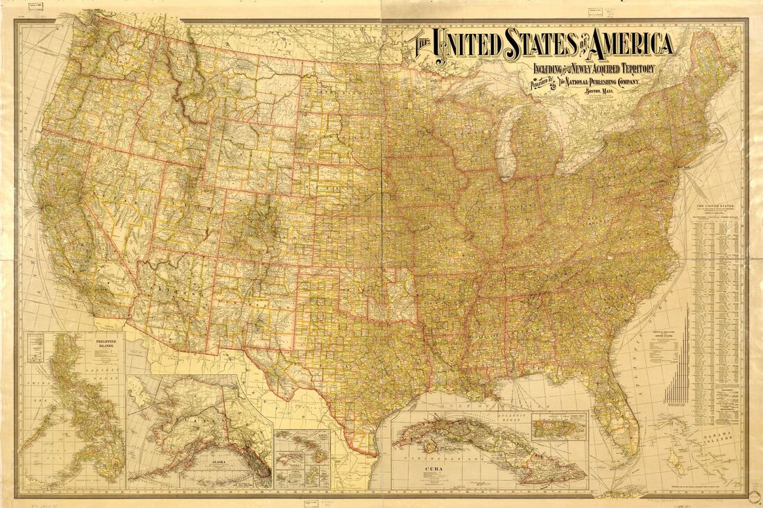 USA in 1901 interactive map at: https://www.loc.gov/resource/g3700.ct001444/ "The Vermont" was the name they gave to the 1903 Winton car. Included among the items that the doctor and his mechanic brought on the trip, was a block and tackle, which came in very handy, all too often, for pulling the car out of ditches, creek beds, and wet spots. Ken Burns did a great PBS documentary on Dr. Jackson and his early cross-country trip, titled “Horatio’s Drive”. There are several short excerpts from “Horatio’s Drive” available on YouTube, but if you want to watch the whole documentary, it looks like you have to purchase it. Here are a few links to some of the great excerpts of “Horatio’s Drive”, available for free viewing: 1. Heading Out from San Francisco: Length = 1:46 https://www.youtube.com/watch?v=7icmrGhwqRY 2. Horatio's Drive: Lost in Wyoming. This excerpt is about the time they broke down in Wyoming, and were able to get going again using some parts from a farmer’s “mowing machine”. That’s the old “can-do” attitude, right there! Length = 3:19 https://www.youtube.com/watch?v=rt_wyIR4tGg 3. Horatio’s Drive: New York Length = 1:49 The arrival at the finish line. https://www.youtube.com/watch?v=hKYLQi8VQlw&t=109s Early Vehicle Licensing in Vermont: 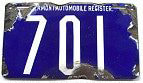 1905 "VAR" License Plate; first year for Vermont. Courtesy: www.uvm.edu/landscape/dating/automobiles/license_plates.php 1905 Saw Vermont’s first year of registering motor vehicles. License plates used were known as porcelain, or enameled iron. The license plates used from 1905-1907 were undated, and only needed room for up to three numerals, as there were less than a thousand vehicles registered in Vermont until 1908. The 1905-1907 Vermont license plates plates had “Vermont Automobile Registry” written across the top. License plate collectors call these plates “VAR” plates, and pay good money for these, Vermont’s oldest plates. If you found one of these on your barn wall, it could be worth several hundred dollars, possibly more. 1915 was the last year of the porcelain license plates in Vermont, and the beginning of a new era for the automobile. Along with the new embossed steel plates came more and more average americans buying and driving cars. This was in great part due to Henry Ford's assembly line built, mass marketed, Model-T's. And with this new found mode of fast transportation, came the need for better roads. In 1903, Dr. Horatio Nelson of Vermont took the first cross-country motor car trip across the USA. In many places, what passed for roads were horrible. Forty years later, in 1943, my father and his parents moved to California from Connecticut. They drove on the Lincoln Highway, and Route 66. These were the roads you took to drive across the country in the 1940's. There were no beltways around cities. If you needed to get through Chicago, then, well, you went right through Chicago! There were no interstate highways then, but unlike in 1903, at least there were roads! Today, in 2020, we drive on I-91 or I-89, and turn on our cruise control while having conversations with loved ones via cell phone and bluetooth. Sometimes, as I glance at Mt. Ascutney, or the distant mountains, while on a road trip, I stop and think about the folks of 100 years ago, and the rum runners of the 1920's. Then I think about the motorists of 120 years ago, when motor carriages were new-fangled curiosities, and limited access highways were dreams of the future. Then I think back further, about what it was like before the car, but when the railroad was king. And before that, when a good horse was a common way to get somewhere fast. And I like to think of the days hundreds of years ago, when there were no horses here, and when the "People of the Dawn" traveled along footpaths and cruised in rivers with hand crafted canoes. The Lincoln Highway opened in 1913. There is a great documentary on the history of the Lincoln Highway, which was mostly replaced by Route 30, which, in turn, was eventually replaced by Interstate 80, leaving abandoned motels, gas stations and watering holes in its wake. My wife and I watched it last night and loved it. You can check out the excellent one hour documentary by Wyoming PBS here: 100 Years on the Lincoln Highway, by Wyoming PBS: https://www.youtube.com/watch?v=SIW2-bH84u4 Thanks for traveling down Old Roads, Rivers and Rails! Please share these stories with friends if you like them. Here are a few old license plates from my collection: The first is the only porcelain plate I own, a 1918 one, from New Hampshire. 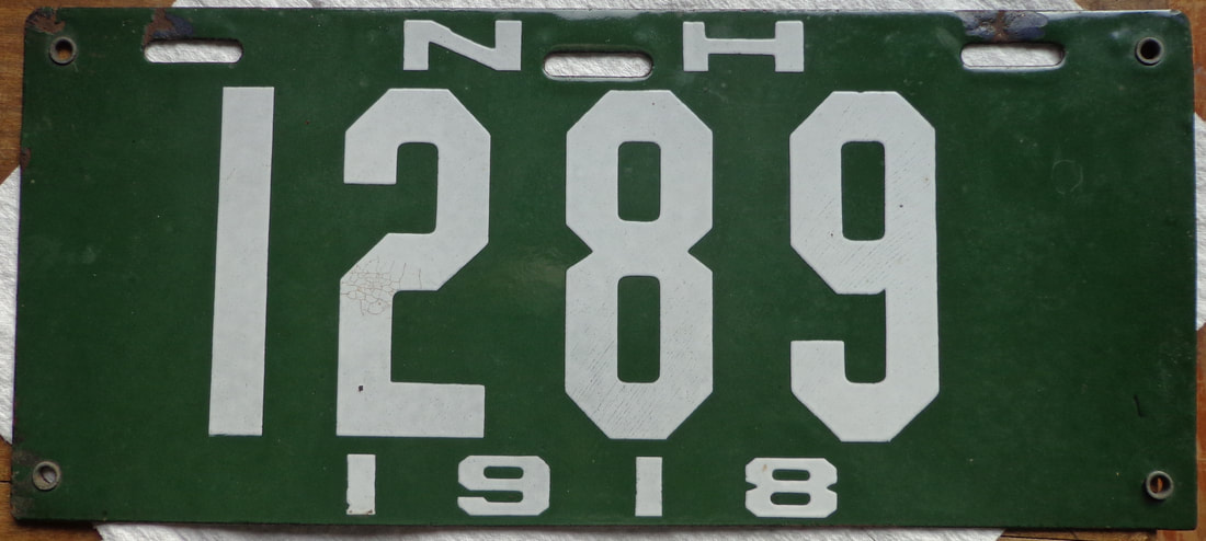 1918 New Hampshire Porcelain License Plate. 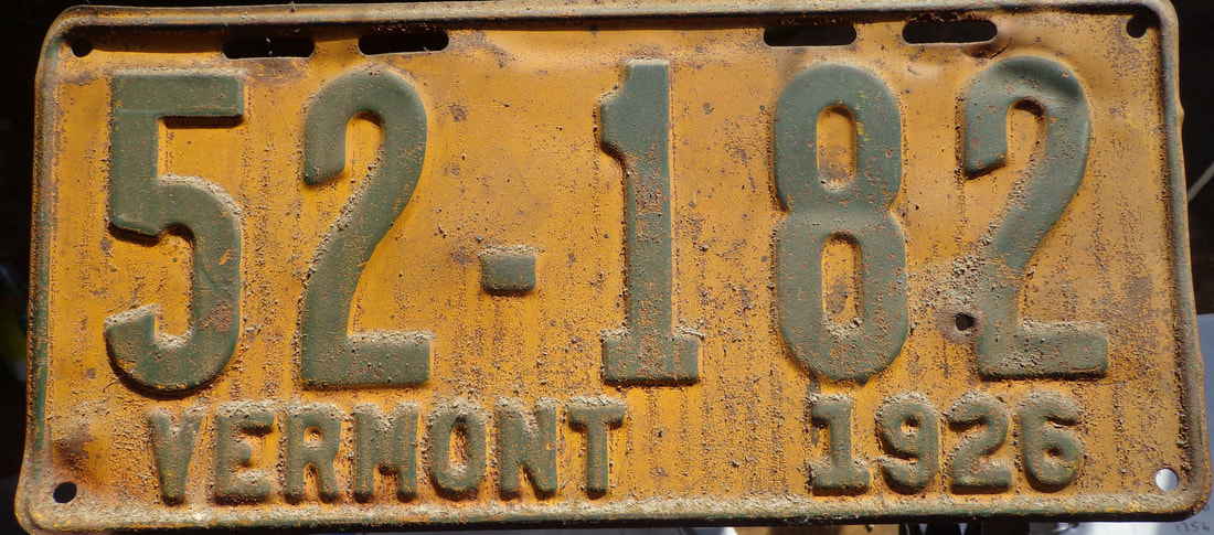 1926 Vermont steel license plate 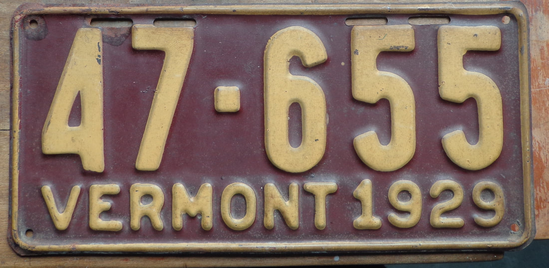 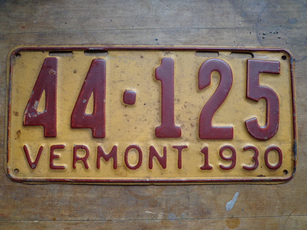 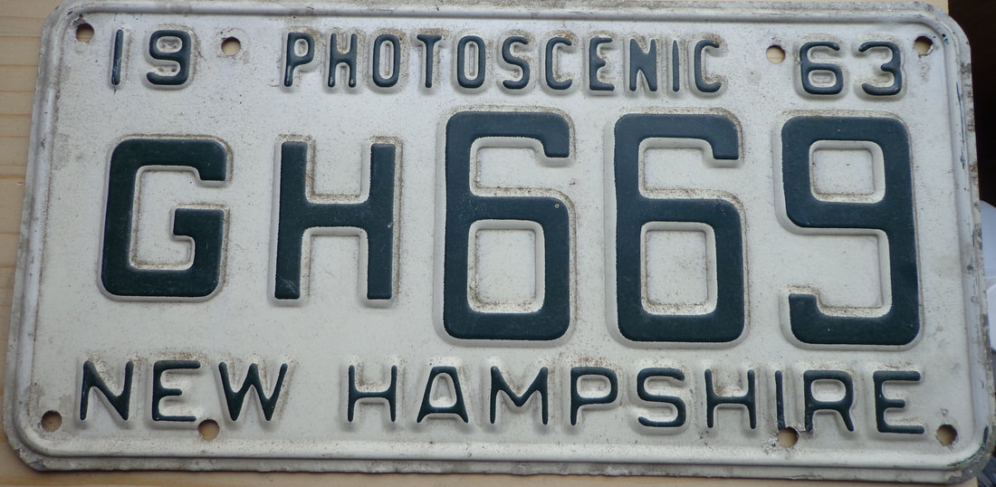 "Photoscenic" New Hampshire, 1963 only 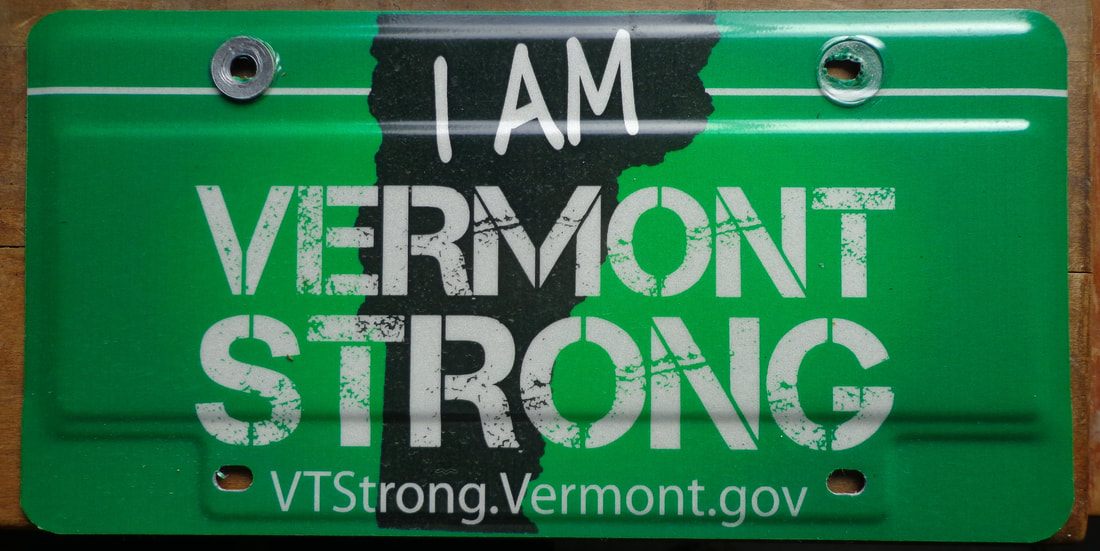 "I Am Vermont Strong" license plate issued after Tropical Storm Irene Sources:
Video: JAY LENO’S STANLEY STEAMER: Length = https://www.youtube.com/watch?v=hgH88xrYdE4 HORATIO’S DRIVE: THE CREW. PBS https://www.pbs.org/kenburns/horatios-drive/the-crew/ PORCELAIN COLLECTORS VERMONT PAGE: http://porcelainplates.net/vermont_archive.html UNIVERSITY OF VT LANDSCAPE CHANGE PROGRAM - DATING VERMONT LICENSE PLATES: https://www.uvm.edu/landscape/dating/automobiles/license_plates.php HISTORY OF VERMONT LICENSE PLATES - VT DMV: https://dmv.vermont.gov/registrations/license-plates/history-of-vermont-license-plates 1901 Map of USA: https://www.loc.gov/resource/g3700.ct001444/?r=-0.092,-0.138,1.03,0.428,0 Video: 100 YEARS ON THE LINCOLN HIGHWAY - PBS Length = 21 mins. https://www.youtube.com/watch?v=SIW2-bH84u4 WIKIPEDIA ARTICLE ON HORATIO NELSON JACKSON: https://en.wikipedia.org/wiki/Horatio_Nelson_Jackson The Manifold Hazards of Early Motoring Jim Motavali Jul 25, 2018 https://www.cartalk.com/blogs/jim-motavalli/manifold-hazards-early-motoring 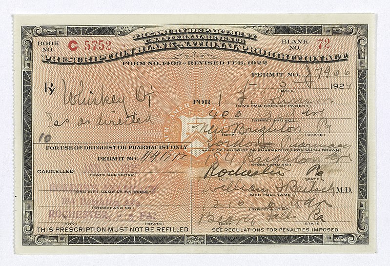 Prohibition Era Prescription for Whiskey. This month marks the 100th anniversary of the beginning of the Liquor Prohibition Era in the U.S. The 18th amendment went into effect in January, 1920. There was a murder at a Dartmouth Fraternity in Hanover in 1920. Henry Maloney was shot by Robert Meads in an argument over a supply of whiskey at the Theta Delta Chi fraternity house. Meads had shot another student a year earlier, though he was not charged for that murder. The first student Meads killed asked not to press charges on Meads because it was just a quarrel with a fraternity brother! Theodore Geisel, also known as Dr. Seuss was a fraternity brother at Dartmouth in the 1920's. He was of german descent, and his father was a beer brewer before prohibition caused him to change his occupation. Geisel was a student during the prohibition era, and after young Theodore had been caught consuming gin at Dartmouth, he was forced to resign from extracurricular activities. So he decided to use a pseudonym, or pen name when writing for a The Jack-O-Lantern publication. That's when he started using the name, "Dr. Seuss". There was an interesting article in the Dartmouth Review, which includes some of the history of alcohol use and attitudes at Dartmouth during the Alcohol Prohibition period, starting in 1920. Here is an excerpt: "In spite of a 1923 vote by the faculty to expel any student caught drinking, Dartmouth soon became a hub for bootleggers. Many students travelled by train to Montreal to drink, while students and entrepreneurs alike worked to smuggle spirits from Canada to Vermont and then onto campus by automobile and train. " Where did the Dartmouth booze come from? One possibility is Barre, VT, via North Troy, via Canada. 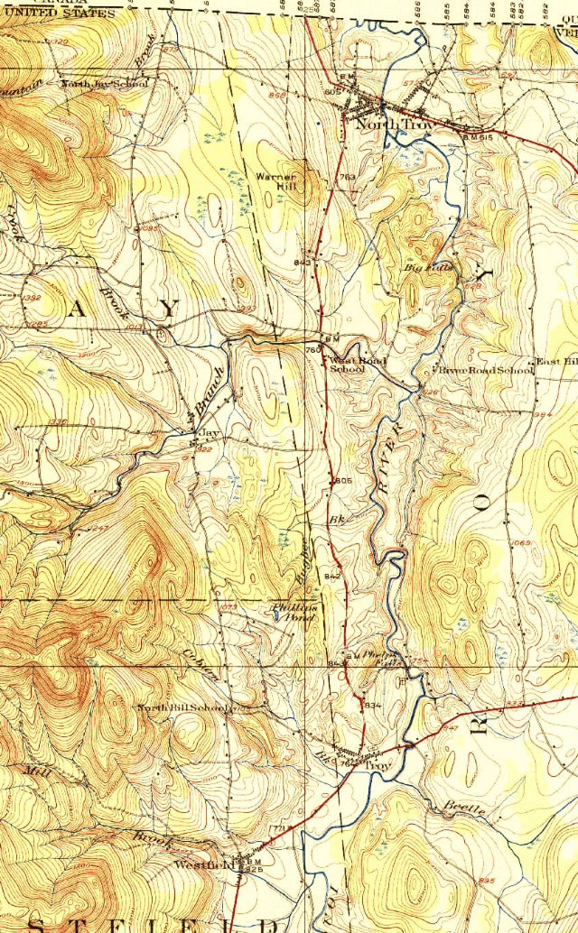 Above: North Troy to Westfield. 1925 USGS Imagery. During Prohibition, North Troy, Vermont was a major bootlegging hub, located near Highwater, Quebec, at the Canadian border. Alcohol was legal in Canada at the time. "Linehouses" existed right on the Canadian border, and were establishments for legal drinking. People used to make pilgrimages to Canada to spend time drinking at the linehouses, and also to attempt to smuggle a supply of illegal booze back into the USA . Barre, Vermont was a secondary hub. Rum runners would get supplied in North Troy, and head down to Barre, which was sort of a booze depot at the time of prohibition. Clarence Morse was 91 years old when he was interviewed by vermonter.com about his experience as a rum runner in the 1920's. Clarence recalled going through the towns of Westfield, Waterbury and Montpelier, while running booze down from North Troy. Below: Westfield to Lowell, VT. Map is from 1925 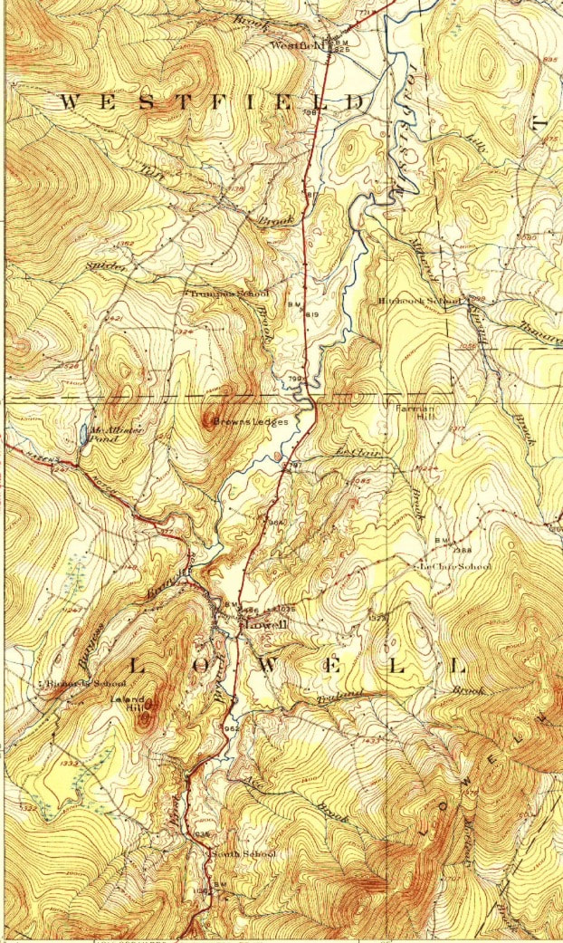 The route they took from the North Troy to Barre, looks interesting. Basically they headed south through the Missisquoi River valley. If you were to approximate that route today, it would probably take you down route 101 south out of North Troy. From there you would probably pick up Route 105, and then Route 100 south. The rum runners might go through the towns and villages of Jay, Westfield, Lowell, Eden Mills, North Hyde Park, Hyde Park, Morrisville, Stowe, Waterbury Middlesex, Montpelier and finally, Barre. 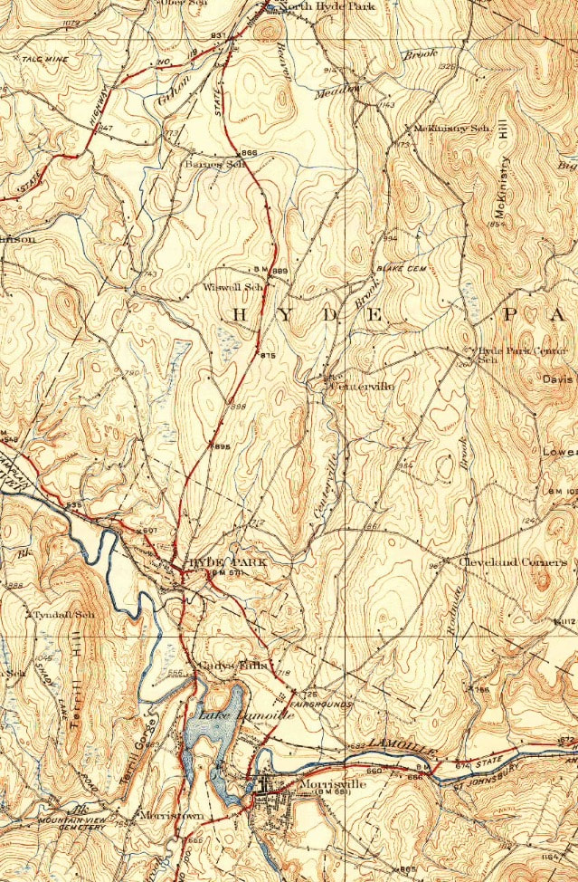 North Hyde Park to Morrisville 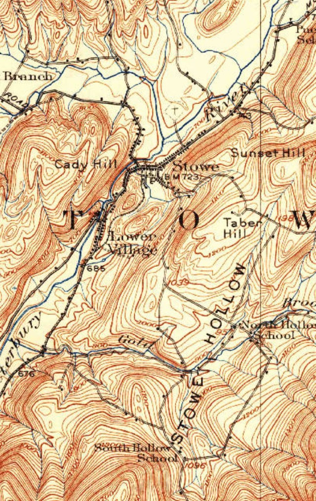 Close-up of Stowe and Stowe Hollow 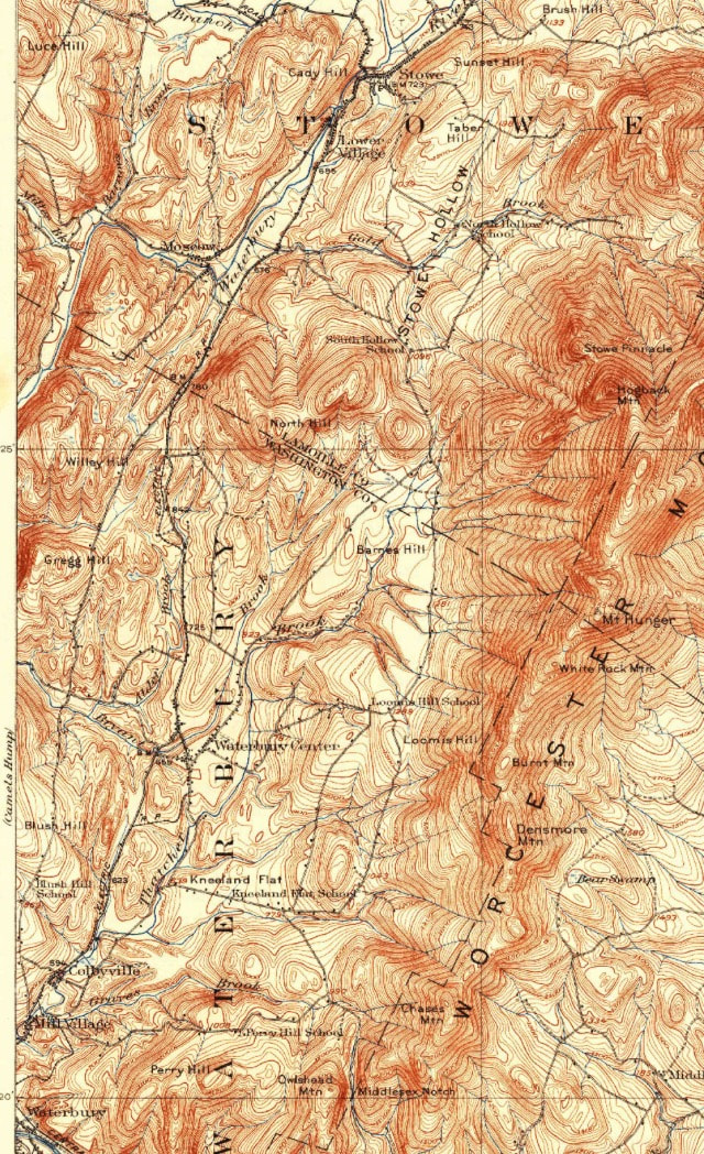 Stowe to Waterbury I'm betting they took many back roads, and "shortcuts" through the hillier areas, in order to skirt the village centers. These would have been the roads that were older and steeper, and in rougher condition. Considering the cars that were being driven in the 1920's, it would have been some kind of ride, especially with the law on your tail. Rum running was an extremely dangerous occupation, though quite lucrative. Many of the people who ran the booze down from Quebec from Barre, were locals, like Clarence Morse, who had been enticed to take a load down to Barre, by the "moneymen". The moneymen were the ones who paid the locals to take loads of booze to Barre. That way the locals took the biggest risk, and the moneymen got paid well. The locals didn't get paid unless the shipment was delivered successfully. Of course, the police knew about this, and knew the routes that were taken, so they would often be lying in wait for an unwitting rum runner. Clarence Morse related that when he agreed to take a shipment from North Troy to Barre, the "moneyman" promised him payment, but there would be no payment until the shipment delivery was complete. Once Clarence and his friends arrived in Barre, they brought the car with the booze to a five bay garage, and then pulled the car into a bay, shut the door, and left for an hour. Upon returning to the garage, they would find $125 on the car seat, and drive away. Clarence said times were tough, and the extra money really helped out. 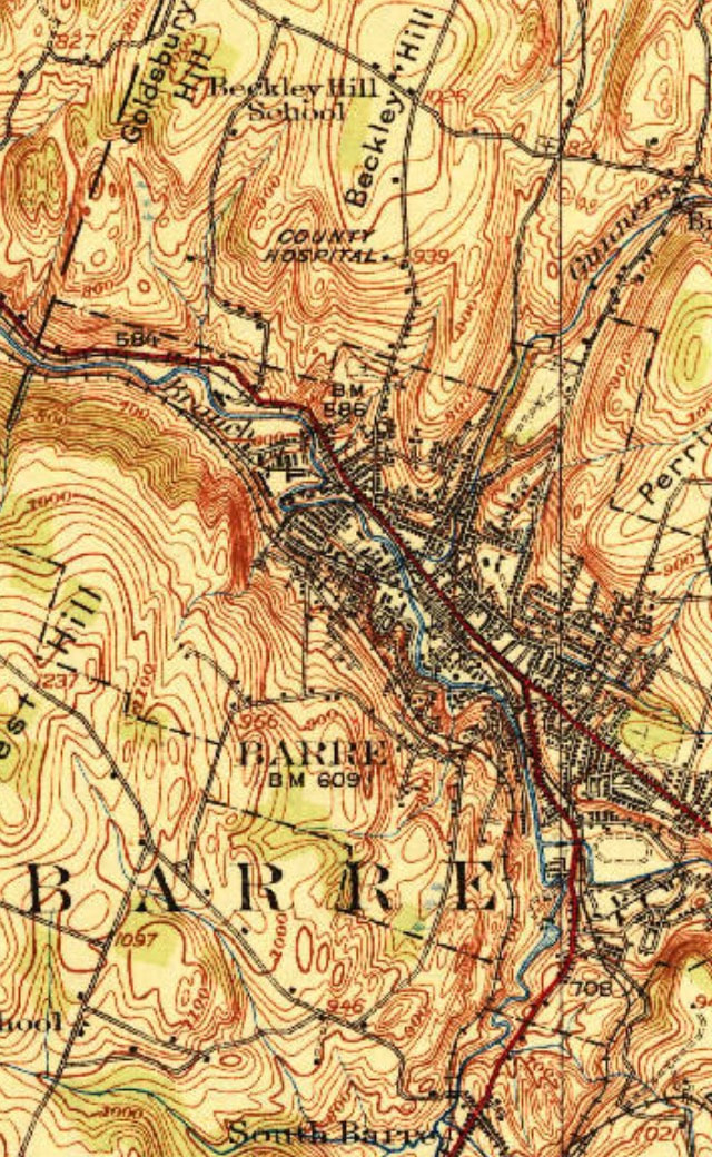 How times change! When I attended the University of Connecticut, back in the late '70's and early '80's, the legal age to drink alcohol was 18. Pretty much anyone who went to college was of legal age to drink. We had "package stores" that sold liquor. There were plenty of package stores in or near Storrs, CT in those days, and they were extremely obliging to young college students who had a desire for things like kegs of beer, and fifths of 190 proof grain alcohol, which fueled weekly parties. There was one package store that would not only sell you a keg of beer, but they would also deliver the keg to your dorm, set it up with the tap, bring you complimentary ice to keep it cold, and pick up the empty keg the next day. They even did all that without charging a deposit! All that has changed though, along with laws and attitudes regarding alochol consumption. Years ago I suffered from recurring nightmares about my college years. Most of the unpleasant dreams involved not knowing where my class was being held, and needing to get there for a final exam, or just plain being unprepared for a test, that kind of thing. I wrote a song about it, and made a video with it about a year ago, in part celebrating Dartmouth's 250th anniversary with some vintage photos from that college. Here is a link to the video: Going Back to College in My Dreams
Once I'd written the song, the nightmares went away! Here are the two articles I used for this post. Both have much more information and are well worth reading: Sources: http://dartreview.com/prohibition-destroys-dartmouth/ https://vermonter.com/bootlegging-vermont/ Photo of prescription for whiskey courtesy wikimedia commons. The map images used came from Topoview at usgs.gov which is also linked on the "MAPS AND LINKS" page of this website. Thanks go to "Out on a Limb" for musical accompaniment on the song, and also to Dartmouth Libraries for use of vintage photographs. - Bob Totz UPDATE: GREAT SONG BY BAYLEY-HAZEN BOYS, ABOUT HAULING BOOZE: "We sneaked across the border and we headed on down with another load of liquor into Barre Town"... THANKS TO JIM AND JOHN FOR THE INFO: https://www.youtube.com/watch?v=2h5U8yf4XaI 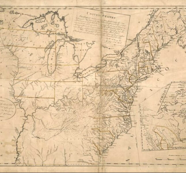 Map of the USA in 1783, Following the Paris Peace Treaty Upon the turning of the New Year, warm wishes are given to friends and family for peace and prosperity. But what is peace, really? I've heard of the phrase "peace and quiet", so I guess peace isn't just quiet, though quiet can certainly accompany peace. The other day, I was at a friend's house, and someone started yelling to someone on another floor of the house. They probably didn't realize how close they were to me, and that the decibel level coming at my ear really bothered me. I can say though, that I experienced a sudden feeling of not being at peace. So quiet certainly can help in the peace experience. In the warm weather, I like to sit in the backyard in the afternoon, and close my eyes, and focus on what I hear, smell, and feel. Usually it's quite peaceful. I might focus on some chicadees or sparrows singing in the background. Maybe I feel a nice warm breeze, and maybe I smell fresh air, or a campfire, or some food cooking. It can all be very peaceful to me. However, if a blue-jay starts shrieking, or the sun goes behind a cloud and a hard cold wind picks up, or I smell a skunk, it suddenly it doesn't seem so peaceful out. What happened to the peace? It seems peace is affected by all of our senses. I think peace is a fleeting feeling. When you think you have it, realize it, and smile. Be aware, and enjoy. Things can change quickly and affect your peace of mind. Perhaps we're really at peace when we're sleeping, but of course, that's not always the case, depending on how much you dream. If you dream a lot, and maybe recently woke up from a nightmare, you might not think of sleep as being particularly peaceful. Back in December 1993 I had a job interview for a postmaster's position, at the federal building in Rutland, Vermont. While at the interview, there was a construction crew making major renovations close to the office where the interview was held. When asked a question from my would be supervisor, I would start to answer. Then, out of nowhere, my response would be totally drowned out by saws, compressors, banging, etc. Instead of attempting to yell over the noise, I simply stopped talking, smiled, and waited for the noise to end. About a year later, at my postmaster's installation ceremony, my supervisor referred to that interview during her short speech. She said that one of the reasons she hired me was because I stayed calm and was patient during that noisy interview. I like to think of it as "being in the eye of the hurricane". I don't take credit for that, but it's kind of like a guide for life, trying to stay calm, or at peace, regardless of what events may be swirling around you. So far it has served me well. It reminds me of the time the postal inspectors and state police spent the entire day at the Post Mills Post Office, x-raying a package that contained explosives. The best part was late afternoon, when they finally blew the package up in a nearby field with a water cannon. It wasn't a particularly peaceful day for me, but I did my best to do that hurricane thing! Peace is sometimes defined as what happens when a war ends. In 1783, The Paris Peace Treaty was signed, officially ending the Revolutionary War. I found the map pictured at the top of this post, at the Library of Congress' website, and immediately knew I wanted to look at it more closely. It was produced in 1784, and represents the USA at the time of the Paris Peace Treaty in 1783. I've also linked to this map on the "Maps and Links" page on this website. It can also be accessed at the following link... The United States according to the definitive treaty of peace signed at Paris Sept. 3d. 1783 If you go to the link, the map can be expanded and panned across, showing the details of the young nation, its early place names, funky spellings, boundaries and waterways. So much can be learned just by seeing what was important to include on the map, at that time in history. Perhaps peace, really, means peace of mind, which is a state of mind. And if it is a state of mind, then maybe we can make a conscious decision to be at peace, if we try real hard at it. One of my New Year's Resolutions is to try to be the eye of the hurricane again, and cultivate peace whenever challenged to do the opposite. Whatever you do this year, I hope you can find peace, no matter what your surroundings, and I hope you find it often. What's your resolution? Feel free to write your resolution in comments, or any thoughts you may have on peace. - Bob Totz, January 2, 2020 Feel free to share this post with friends. It can be accessed at https://oldroadsuppervalley.weebly.com/home/peace-paris-and-the-po |
AuthorI'm Bob Totz, retired VT postmaster, and historical geographer ARCHIVES:
October 2021
EXPANDED ARCHIVES: AUGUST 2021 1858 Johnson Map of North America MAY 2021 1795 - "Road Over the Mountain" - Part Two Historic Toll House For Sale 1795 - "Road Over the Mountain" Part One OCTOBER 2020 Finding That Special Peaceful Place AUGUST 2020 Kayaking on the Pompy JULY 2020 Pt. 2: What the Heck Are These Things? JUNE 2020 Bob's Bio... What the Heck Are These Things? Pt. 1 MAY 2020 Stone Walls and Spirits The View APRIL 2020 Sunny Brook Farm Relics: Pt 2. Sunny Brook Farm Relics: Pt 1. MARCH 2020 Signs of Norwich Pt. 2 COVID-19 Tracking Map Centertown and Valleyquest Signs of Norwich Pt. 1 "Imperfect Union" - Book Review Historic Centertown FEBRUARY 2020 King's Hwy Pt. 2 WRJ Museum at Post Mills Airport Chatauguay Vermont The Independent Farmer poem Traveling Along the King's Highway - Lebanon NH JANUARY 2020 Finding Parkhurst Cemetery In Search of Parkhurst Cemetery Affordable Housing The Old Stone Grill Two Rivers Trail-Kmart License and Registration, Please! Prohibition, Murder and Dr. Seuss Peace, Paris, & P.O. DECEMBER 2019 BLOGGER'S LINKS Welcome to Old Roads Love-Quail Hollow fun Dartmouth Cemetery SEPTEMBER 2019 E. Thetford Cemetery JUNE 2019
Taps: Meetinghouse Cemetery 4-Corners Borders Quest Old Iron Gate Stumbling Upon History Sunrise Walk MAY 2019 4 Corners Cemetery Strafford's Abandoned Foundations Art in Old Stonework APRIL 2019 Strafford Tpke Pt 2 Strafford Tpke Pt 1 White River Valley FEBRUARY 2019 Learning from Historic Maps of the Upper Valley Change in Lewiston VT JANUARY 2019 A Vermont Ski Waltz John Ledyard 1773 What is the Upper Valley? DECEMBER 2018 Dartmouth Green Music Video: Sometimes Music Video: Montreal Express Railway Disaster of 1887 |
 RSS Feed
